
About the Ecoregion
The Klamath-Siskiyou Ecoregion is the ancestral homelands of at least 17 Indigenous tribes: Yurok, Karuk, Hoopa Valley (Hupa/Natinixwe), Tolowa Dee-ni’, Resighini Rancheria, Chetco (Chit-dee-ni’), Tutuni, Shasta, New River Shasta, Konomihu, Takelma, Latgawa, Cow Creek Umpqua, Upper Coquille, Klamath, Modoc, and Yahooskin (Klamath Basin connection). Source: ChatGPT overlay of tribal polygons within the EPA Level III boundary of the ecoregion.
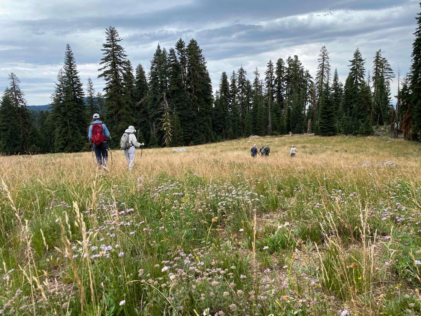
Siskiyou Crest Coalition hike near Mt. Ashland in the McDonald Peak roadless area (Photo: L. Ruediger)
The ~12 million-acre Klamath-Siskiyou Ecoregion (KSE) is one of the most biodiverse temperate conifer forest ecoregions on Earth (DellaSala et al. 1999). Among its many accolades, the KSE is considered an area of “global botanical significance” (one of seven in North America), a “global centre of plant diversity,” a proposed UNESCO (United Nations) “biosphere reserve” and a World Wildlife Fund Global 200 ecoregion (DellaSala et al. 1999). Many taxa achieve exceptional levels of species richness (total number of species in an area) and endemism (species restricted mainly to the ecoregion) in the KSE, including mollusks (land and aquatic snails), bees, butterflies, birds, and amphibians (see DellaSala et al. 1999 for a review). Additionally, there are some 30 (DellaSala et al. 1999) to 35 conifer species (Kauffman and Garwood 2022 p. 193) within the KSE, depending on the ecoregional boundary (see Figure 1 below), including 3 endemic conifers – Port Orford Cedar, Brewer’s Spruce, and Baker’s Cypress. Notably, a day’s hike in the Russian Wilderness of the Trinity Alps can yield 18 conifer species along a single trail (Kauffman 2013).
Sum-of-the ecoregional parts – global centre of plant diversity (3,500 recognized taxa, 281 endemic subspecies); northern extension of the California floristic province (a recognized global biodiversity “hot spot); exceptional mollusk richness and endemism (60% endemic); exceptional bee and butterfly richness (native pollinators); center of mistletoe diversity, one of only 4 areas in North America (3 others in subtropical Mexico) with extraordinary conifer richness; significant old-growth forests, roadless areas, and Lands with Wilderness Characteristics that may act as refugia in a rapidly changing climate (DellaSala et al. 1999, 2026).
High levels of biodiversity within the KSE are presumably due to:
- Ancient topography of the mountains that provide a “nursery” or outdoor laboratory for speciation events over millennial time scales (e.g., numerous Neoendemics – recently arisen species/subspecies, and Paleoendemics – formerly widespread now restricted).
- Absence of glaciated and volcanic periods that provide refugia.
- Varied topography, including east-west running mountains, up-down elevational corridors, and subranges that provide niches for varied communities (see Figure 1a).
- Climatic variability consisting of dry, warm interior sections vs wet, cool coastal influences and upper/lower elevational gradients.
- Central location juxtaposed with nearby ecoregions and zones of vegetation overlap.
- Natural disturbance processes such as periodic wildfires of mixed severity effects on vegetation– i.e., “pyrodiversity begets biodiversity” (see below).
- The highest concentration of serpentine bedrock geology in western North America that supports many localized and highly specialized plants (DellaSala et al. 1999).
- Large complexes of wilderness and roadless areas that provide unique refugia.
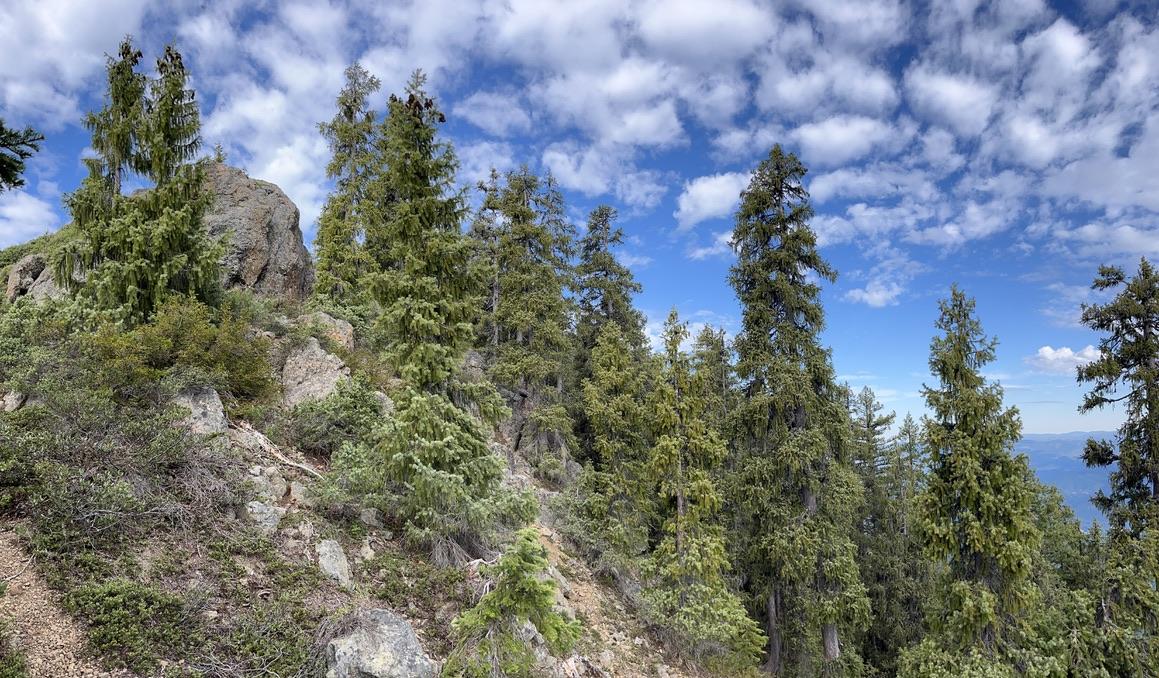
The endemic Brewer’s spruce (Picea breweriana) – or weeping spruce for its droopy needles – in a grove on Kerby Peak at the headwaters of Deer Creek (Photo: L. Ruediger).
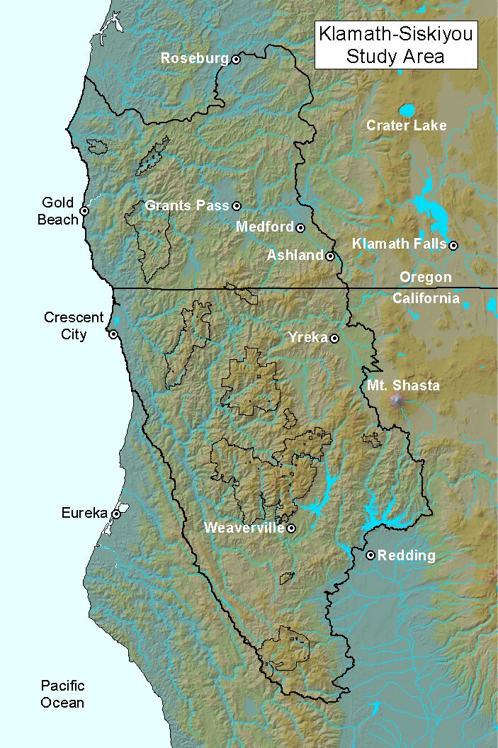
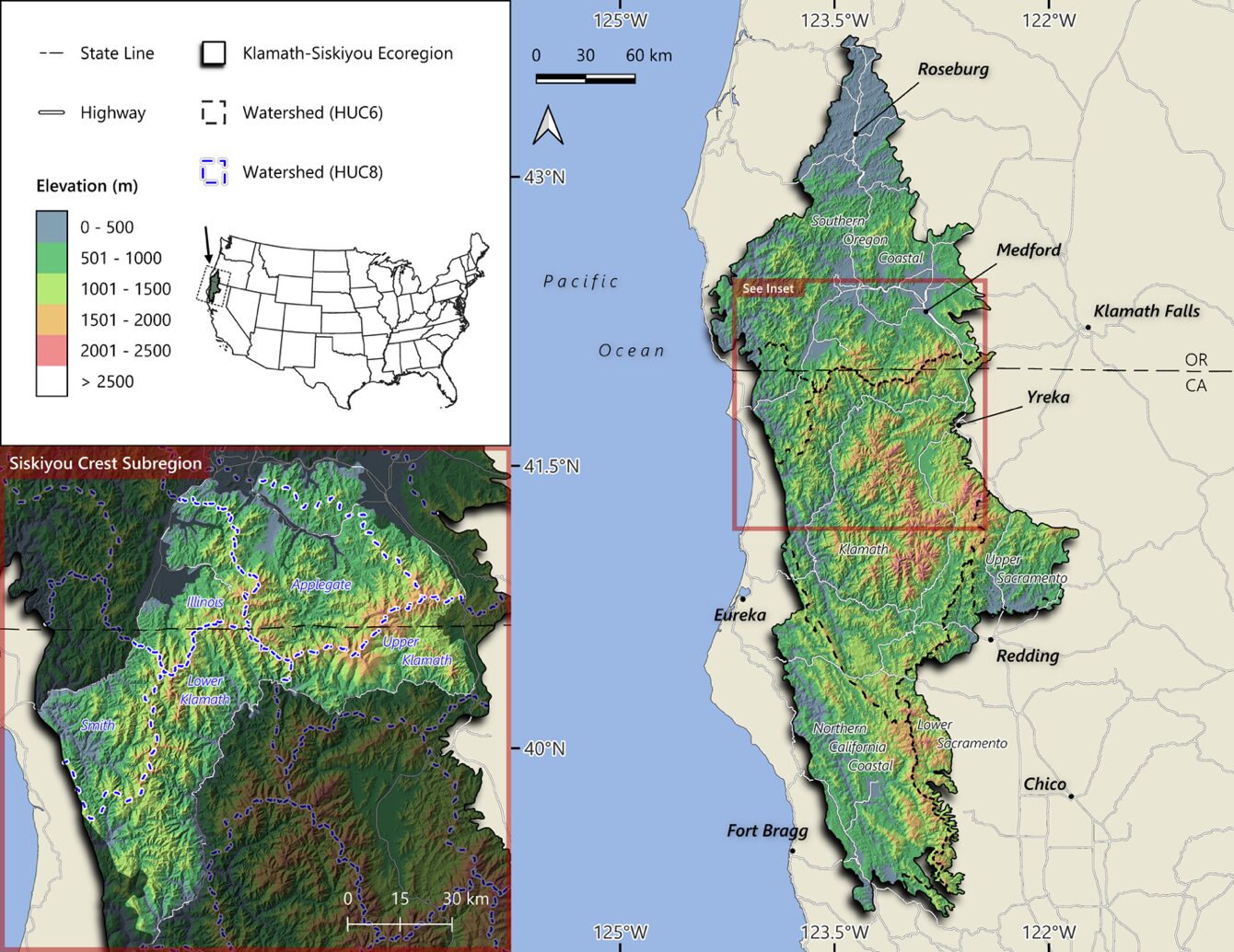
The main mountain range, the Klamath’s, is the result of an ancient geological uplift from colliding continental and oceanic plates that occurred during the late Jurassic to early Cretaceous some 200 million years ago. This twisted-knot like appearance of interwoven subranges (i.e., “the Klamath Knot”) is exemplified by the juxtaposition of the Siskiyou Mountains north of the Klamath drainage, and the ranges south of the Klamath including, the Marble Mountains, Scott Mountains, Trinity Mountains, Trinity Alps, Salmon Mountains, and northern Yolla-Bolly Mountains (Figure 1a).
(a)
(b)
Figure 1. (a) The Klamath-Siskiyou ecoregion as defined by World Wildlife Fund showing the twisted, “knot” like arrangement of the mountains. This boundary was used in DellaSala et al. 1999 for the WWF Global 200 analysis. (b) Klamath-Siskiyou Ecoregion with a zoom in on the Siskiyou Crest Subregion that was used in DellaSala et al. 2026 based on EPA Level III classifications that are most often used by federal agencies.
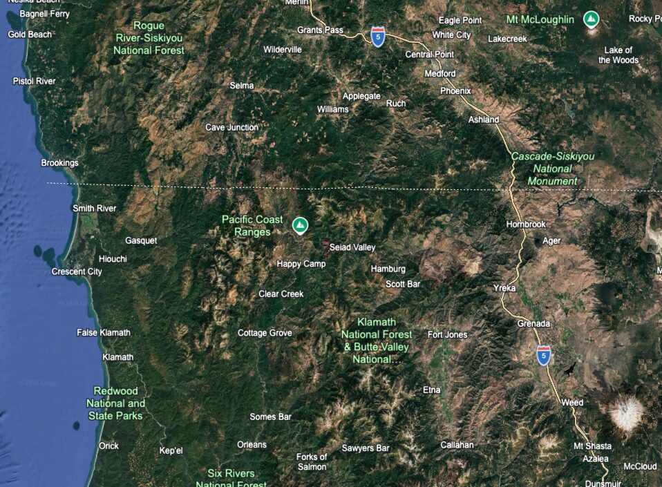
Figure 2. Google Earth image of the Klamath-Siskiyou-Siskiyou Crest Subregion showing the intermix of Wilderness Complexes (high elevation gray areas west and south of Cave Junction), Cascade-Siskiyou National Monument (eastern edge) and degraded lands (clearcuts appearing as small polygons).
Notably, approximately one-half to two-thirds of the KSE and SCS, respectively, is managed by the US Department of Agriculture Forest Service and US Department of Interior Bureau of Land Management, providing ample opportunities for large-scale conservation on public lands (DellaSala et al 2026). However, only ~15% of each of the KSE and SCS are in protected areas (e.g., parks, wilderness) which is far less than needed to maintain the ecoregion’s unique biodiversity under unprecedented stressors from land development and climate change (DellaSala et al. 2026).
Importantly, the KSE has a long natural history of scientific and conservation interest beginning with the pioneering botanists that catalogued unique plant species in the late 1800s (many species bare their scientific names) to contemporary reserve design approaches focused on representing portions of the ecoregion in conservation reserves (Noss et al. 1999, DellaSala et al. 2026). The 114,000-acre Cascade-Siskiyou National Monument, designated by presidential proclamation on June 9, 2000; the 4,480-acre Oregon Caves National Monument (designated in 1909); several Research Natural Areas, Areas of Botanical Significance, Inventoried Roadless Areas, and Areas With Wilderness Characteristics are dispersed within a matrix of degraded areas throughout the ecoregion (Figure 2). Importantly, the Siskiyou Crest Subregion needs comparable conservation attention as summarized in the following sections. Additionally, for more information on the subregion, go to the Siskiyou Crest Coalition website.
About The Siskiyou Crest Subregion
The ~1.7-million-acre Siskiyou Crest Subregion (SCS) within the KSE represents ~14% of the KSE and is the only high elevation east-west-running land-bridge (Figure 1b). The subregion was mapped by the Siskiyou Crest Coalition using geological strata and watershed boundaries. Specifically, it is demarked by the watershed divide separating the Klamath and Smith watersheds and the Klamath and Rogue watersheds (Figure 3). Subregional boundaries also include the Coast Range to the west and both the Middle Fork and South Fork Smith River. To the east the Siskiyou Crest meets the Cascade Mountains near Siskiyou Summit, and the area is also bounded to the north by the Rogue, Applegate, and Illinois river valleys in Southwest Oregon. While to the south, the slopes of the Siskiyou Crest extend along the north bank of the Klamath River from Cottonwood Creek downstream to Blue Creek.
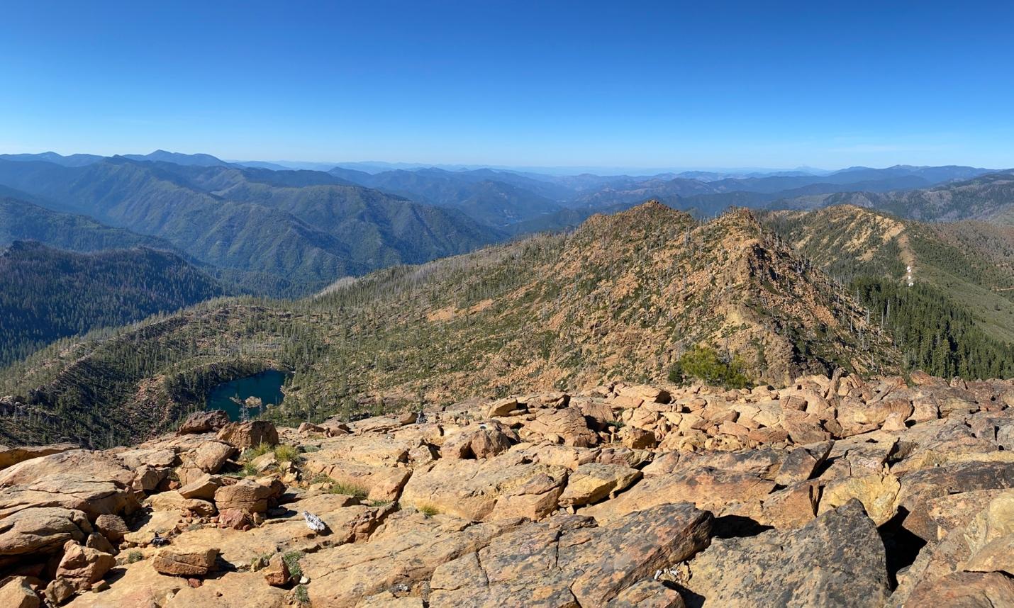
A view across the Applegate River watershed, the Red Buttes Wilderness and the Kangaroo Inventoried Roadless Area from the summit of Red Butte (Photo: L. Ruediger).
The relatively high elevation of the SCS is presumed to act as a land bridge for migrating species across mountain ranges and a climate refugium that can provide cooler, moister conditions and less fire activity than lower elevations of the KSE, although these benefits depend on whether global emissions follow an increasing trajectory (refugium breaks down) or are soon lowered by global and national emissions reduction policies (refugium maintained). The level of logging and road building also will amplify and speed up losses at the ecoregional and subregional scales unless protection efforts are greatly expanded (DellaSala et al. 2026). Most notably, old forests in the SCS (and KSE writ-large), north-facing slopes, high elevation areas, undeveloped areas (Inventoried Roadless Areas, and Lands With Wilderness Characteristics) provide critically important refugia properties in the face of increasing climate driven wildfires than heavily logged and roaded areas and these undeveloped and intact areas need full protection (Olson et al. 2012, DellaSala et al. 2026).
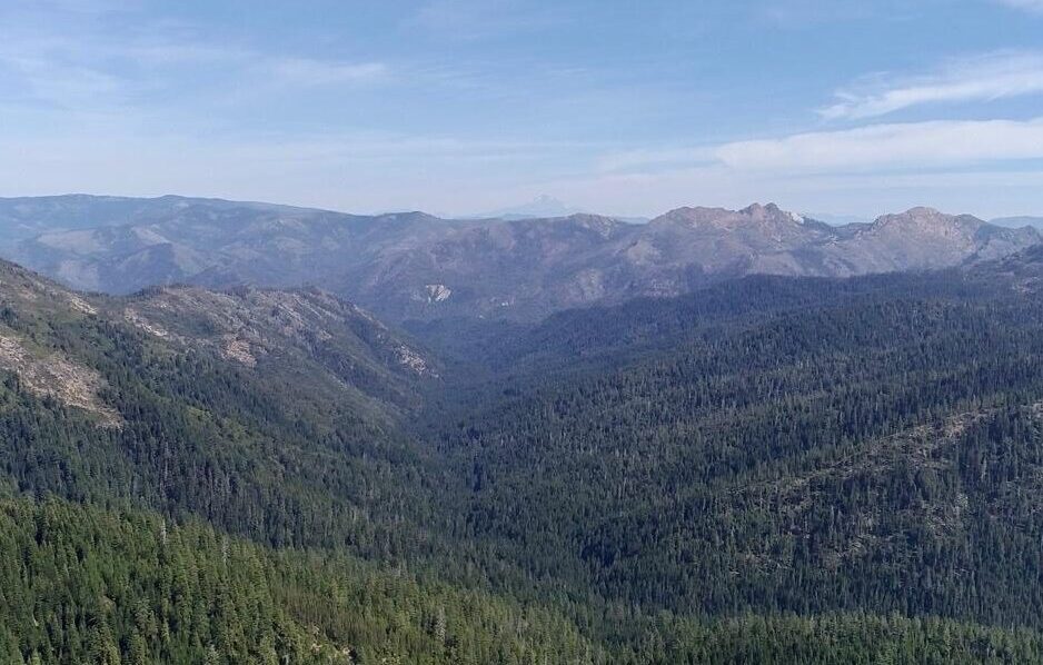
Middle Fork Applegate and snowcapped Red Buttes Wilderness of the Siskiyou Crest Subregion (Photo: Applegate Siskiyou Alliance)
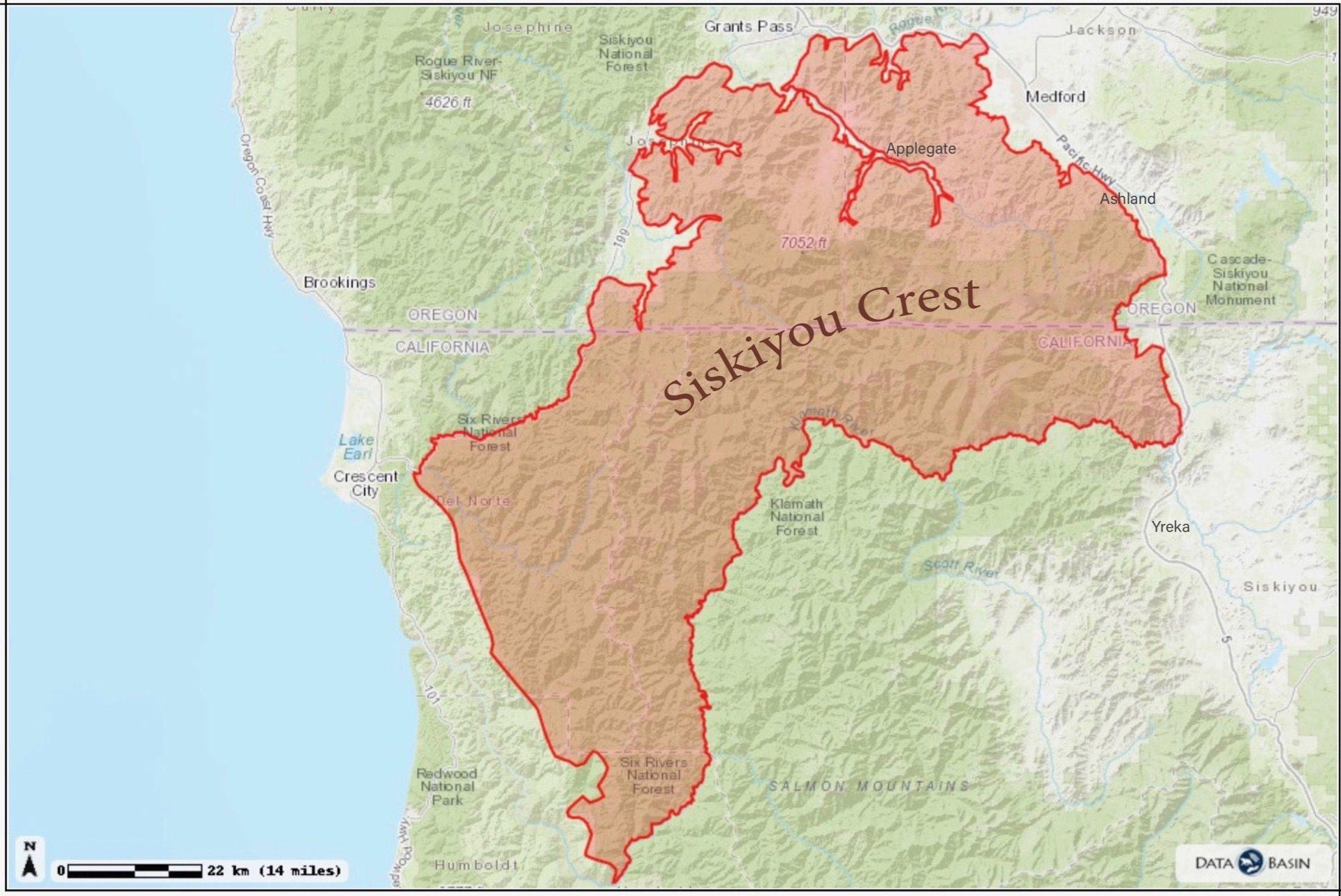
Figure 3. Siskiyou Crest high-elevation land-bridge as mapped by the Siskiyou Crest Coalition (https://siskiyoucrestcoalition.org/about-us/what-is-the-siskiyou-crest/).
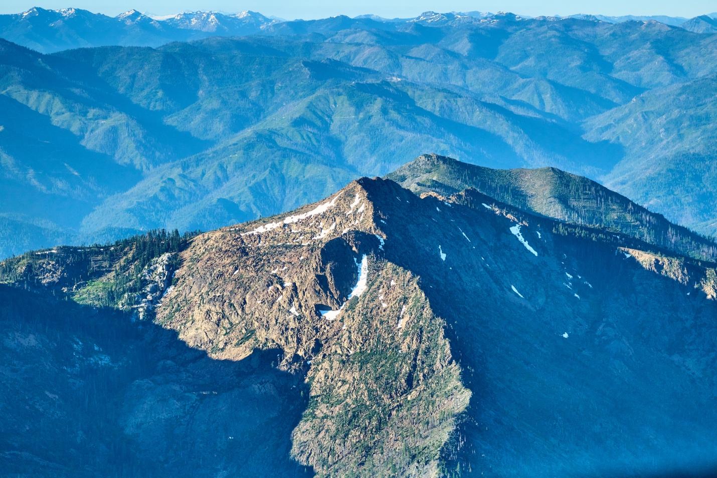
Kangaroo Inventoried Roadless Area, Siskiyou Crest – roadless areas support high levels of species richness, forested ones have high carbon stores, are often at the headwaters of watersheds, and tend to burn less frequently and less intensely compared to roaded and logged areas (Photo: F. Lospalluto taken on an ecoflight)
Sum of the subregional parts – the only high-elevation, east-west running land bridge connecting several subranges; an area of overlapping physiographic (plant) provinces; a movement corridor for wide-ranging species such as Pacific fisher and wolves; important old-forest and complex early-seral forest habitat for spotted owls; extraordinary plant (1,683 distinct taxa identified thus far), bee, butterfly (110 species identified thus far), moth (417 species identified thus far), and bird (173 species identified thus far) species richness; along with large wildland complexes undisturbed by logging and roads that can act as refugia.
Diverse Forests, Grasslands, Woodlands, Shrublands
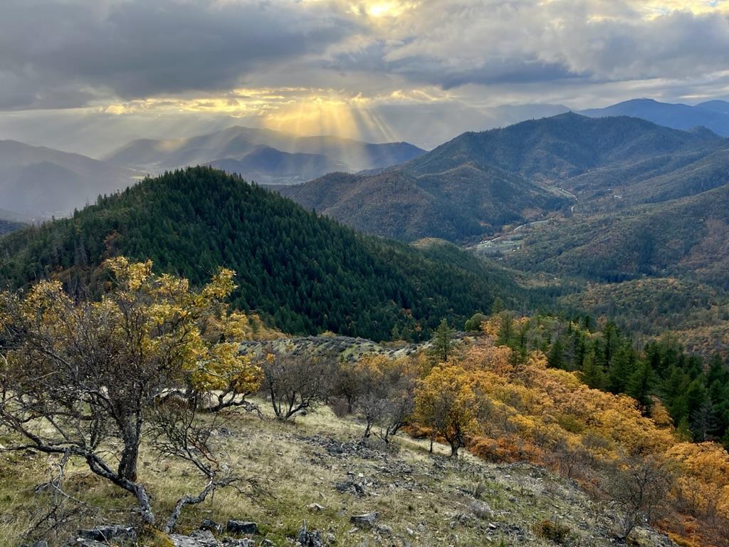
The Siskiyou Crest contains diverse plant communities including oak woodland, oak savannah, arid grassland, the northern extension of California chaparral, and dry mixed conifer forests on BLM lands, including the Wellington Wildland (shown here) in the foothills of the Applegate Valley (Photo: L Ruediger)
DellaSala et al. 2026 mapped 71 “modified biophysical land cover types” (broad vegetation communities) in the KSE and 44 in the SCS. For instance, the mixed-conifer and woodland (both dry and mesic) cover type compromised nearly half of all cover types in both areas and the California mixed-evergreen forest and woodland cover type accounted for the next highest level at ~17% and 26% of the KSE and SCS, respectively. Nearly all the cover types were poorly represented (<30% protected) in protected areas but the gap in representation can improve with stepped up protections for Inventoried Roadless Areas and Lands With Wilderness Characteristics (BLM lands). Notably, scientists globally and via international policies have called for protecting at least 30% of regions by 2030 (so called “30 x 30” campaign effort) and 50% by 2050 (“50 x 50”). Some areas like old forests, Inventoried Roadless Areas, and Lands With Wilderness Characteristics are so vital and rare ecologically that 100% protected is the target (no timeline). Protection levels (30%, 50%, 100%) were assessed to achieve representation targets using methods published in the Ecoregional Conservation Assessment (see below).
Serpentine Cover Type

Serpentine or ultra-mafic soils create sparse vegetation and Jeffery pine woodland on Big Red Mountain, an over 7,000 feet summit at the headwaters of the Little Applegate River (Photo: L. Ruediger).
Serpentine geology in the KSE has been previously studied for its exceptional biodiversity, especially the concentration of endemic plants (see DellaSala et al. 1999). The vast majority of serpentine is concentrated along an area known as the Josephine Ophiolite to the west and south of Cave Junction, Oregon (Figure 4). However, the SCS also has concentrations of this substrate and despite the botanical significance of these areas, protection levels in both the KSE and SCS were only ~25% (below 30% and 50% targets). Permanent protections to Inventoried Roadless Areas and Lands With Wilderness Characteristics would boost levels up to at least the lowest conservation target (30%) as noted in the ECA but even that is too low for this important type.
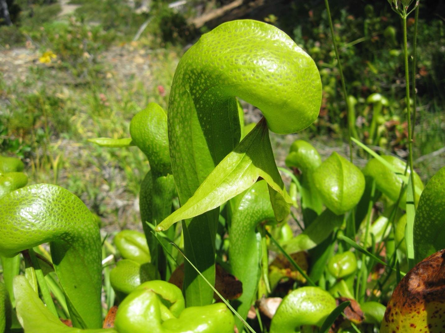
The insectivorous Cobra lily persists in wet areas on serpentine soils and is an indicator of plant-rich environments that include imperiled plant species as well (L. Ruediger).
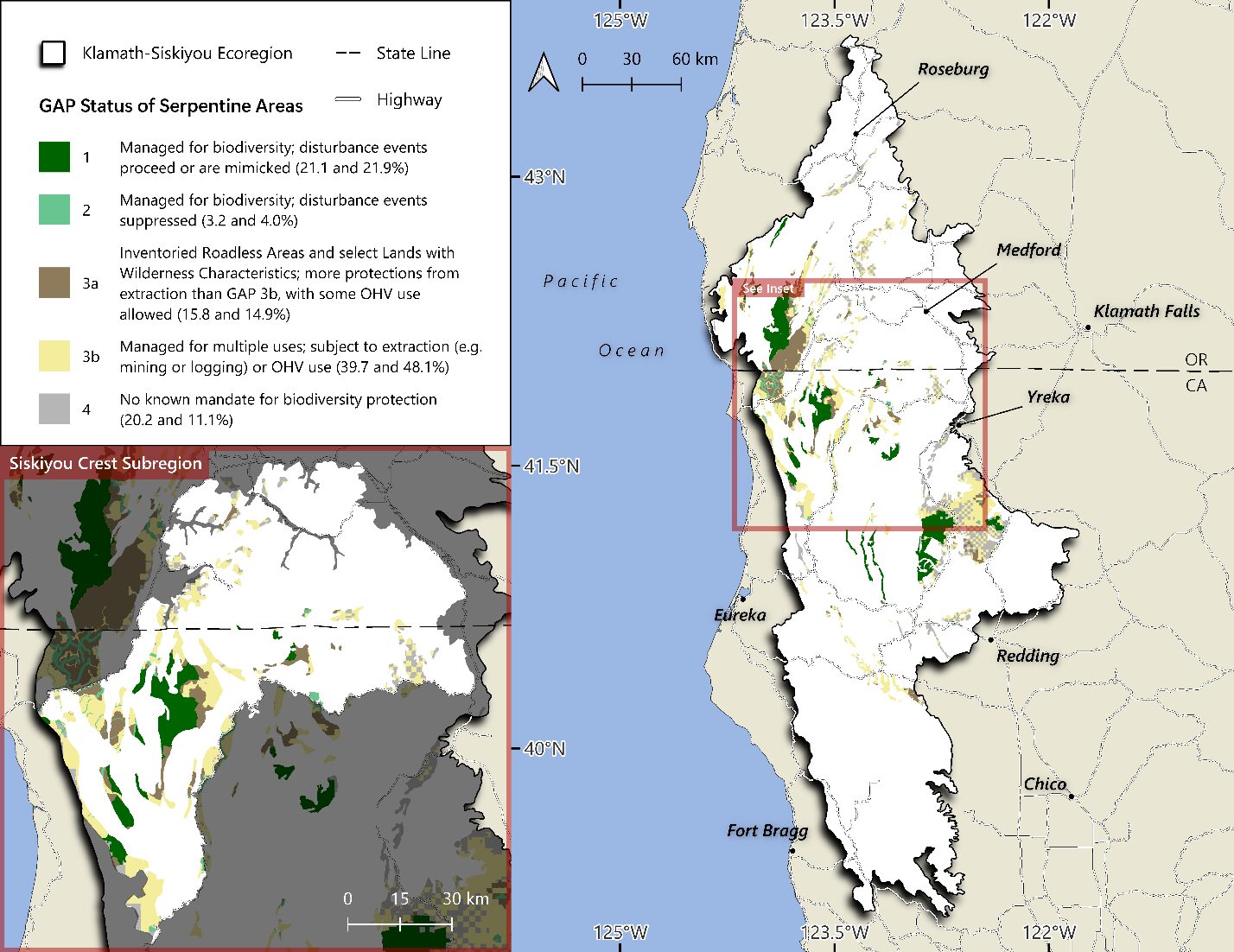
Figure 4. Distribution of serpentine areas in relation to GAP land use status (protected areas are GAP 1 and 2 – green colors while managed areas – typically for timber – are GAP 3 and 4 – brown and gray colors in the KSE and SCS (zoomed area) (DellaSala et al. 2026). Note – inventoried roadless areas (IRAs) were analyzed as having some level of protection but not permanent protection as efforts are underway by the Trump administration to rescind the National Roadless Conservation Rule (DellaSala et al. 2026).
Pyrodiversity Begets Biodiversity: The Role of Frequent Fires
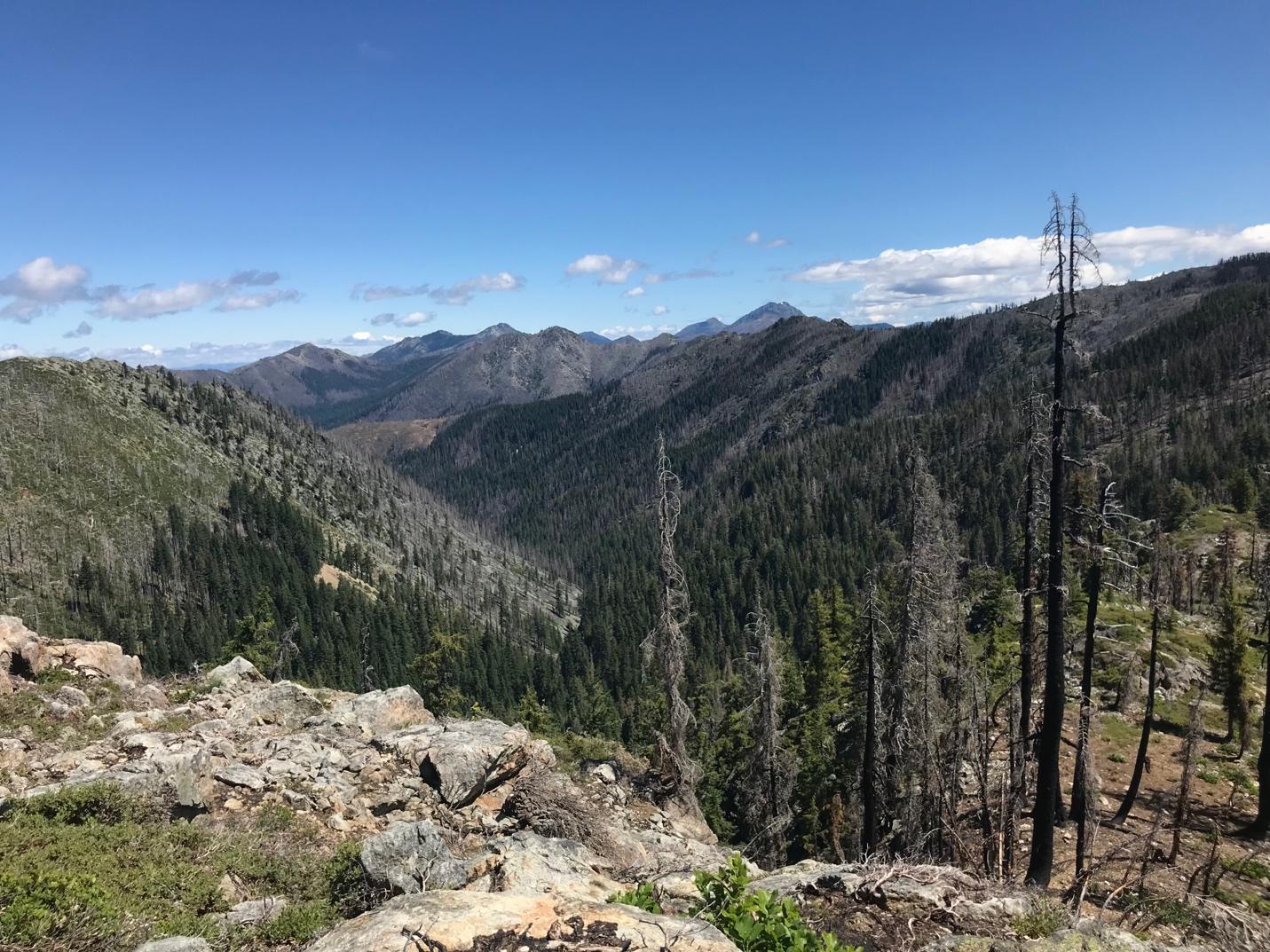
A mixed severity fire mosaic in the Siskiyou Wilderness Area and the Prescott Fork of the Smith River. Fire effects include high, moderate, and low severity, creating pyrodiverse landscapes and the ensuing patchwork of successional stages (Photo: L. Ruediger).
Both the KSE and SCS have a mutually dependent relationship with wildfires of mixed severity effects on vegetation (see photo). The mixture of burn patches and patch sizes is known as “pyrodiversity” and the associated high levels of biodiversity in the various patch types generally has been referred to as pyrodiversity begets biodiversity. Mixed severity fires are made up of a complex array of burn patches (large and small), including where fire skipped over vegetation without killing any canopy trees (unburned), killed only some trees (lightly burned), killed up to half the canopy trees (moderate), and killed nearly all canopy trees in the burn patch (high). If not logged (i.e., postfire salvage), this diverse landscape provides habitat for a diverse assortment of species that utilize regenerating patches (e.g., deer and elk, foraging habitat for spotted owls) and unburned to moderately burned ones that can act as nesting habitat for raptors (e.g., spotted owls, goshawks).
Mature and Old-Growth Forests (MOG)
The Siskiyou Crest Subregion contains a high concentration of mature (~80 years) and old-growth (~200 years) forests (MOG) with many of these older forests persisting through multiple fire events (DellaSala et al. 2026) (Figure 5 especially the SCS zoom in). MOG forests generally support high richness levels of plants, birds, mammals, and amphibians compared to logged areas (DellaSala et al. 2022). And they provide climate (Frey et al. 2016) and wildfire refugia (Lesmeister et al. 2021) that may “lifeboat” species through a rapidly changing climate compared to drier, hotter and more fire-prone clearcuts. Refugia properties of MOG include cooler microclimates – especially on north-facing slopes – and a mixture of hardwoods and conifers with hardwoods believed to provide a ‘wet-blanket’ effect on wildfire intensity due to moisture retention and shading of flammable shrubs (Odion et al. 2004). MOG forests also have high concentration of stored carbon mostly in the largest trees and soils that is important for climate mitigation as natural climate solutions (DellaSala et al. 2022).
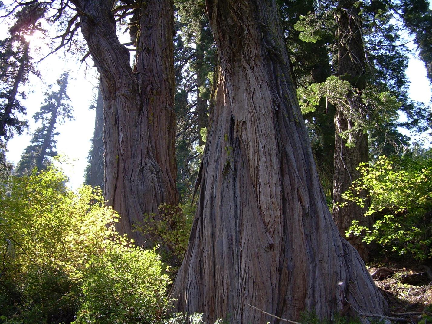
Old-growth incense cedar in the Condrey Mountain Inventoried Roadless Area (Photo: L. Ruediger).
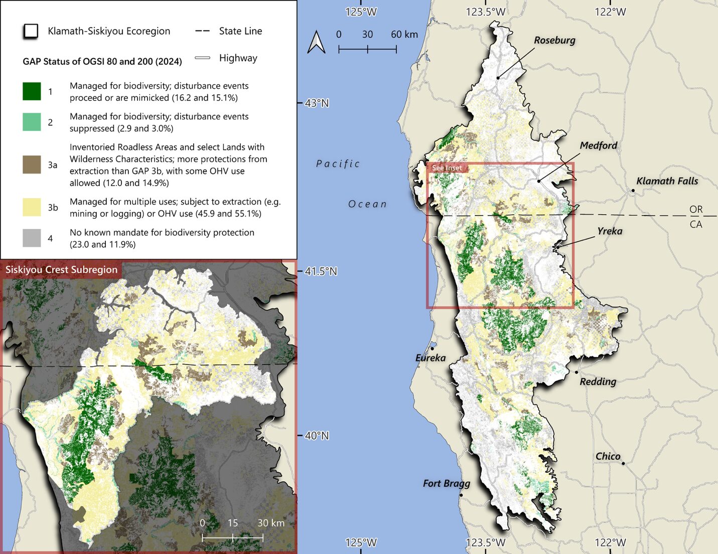
Figure 5. Distribution of old forests (80-200 years) in the KSE and SCS provided from DellaSala et al. 2026. Note the concentration in the SCS zoomed area. See DellaSala et al. 2026 for definitions and discussion.
Complex Early Seral Forests
Ecologists have known for some time that structural complexity (e.g., variability in tree height and ages, snags, logs) in forests is associated with high levels of biodiversity. And while most attention has been rightfully focused on MOG for its biodiversity, carbon storage, and watershed benefits, recent scientific discoveries indicate the importance of complex early seral forests (CESF) generated by severe natural disturbances in old forests. Such natural disturbances contain comparable levels of biodiversity – but different species assemblages – as unburned MOG (Swanson et al. 2010). Notably, CESF is home to exceptional bee and butterfly diversity (pollinators), songbirds and woodpeckers, foraging habitat for spotted owls, mammals (especially prey for raptors), and plants (especially flowering plants and nitrogen-fixing shrubs) mainly because of the abundance of “biological legacies” (Figure 6). Biological legacies include surviving and dead standing trees (snags) and logs, seed banks in soils, surviving shrubs especially those associated with nitrogen fixation and mycorrhizae networks, and surviving populations of wildlife. When logged (“salvage logging”), CESF lose their complexity and are summarily degraded (contrast Figure 6a vs b).
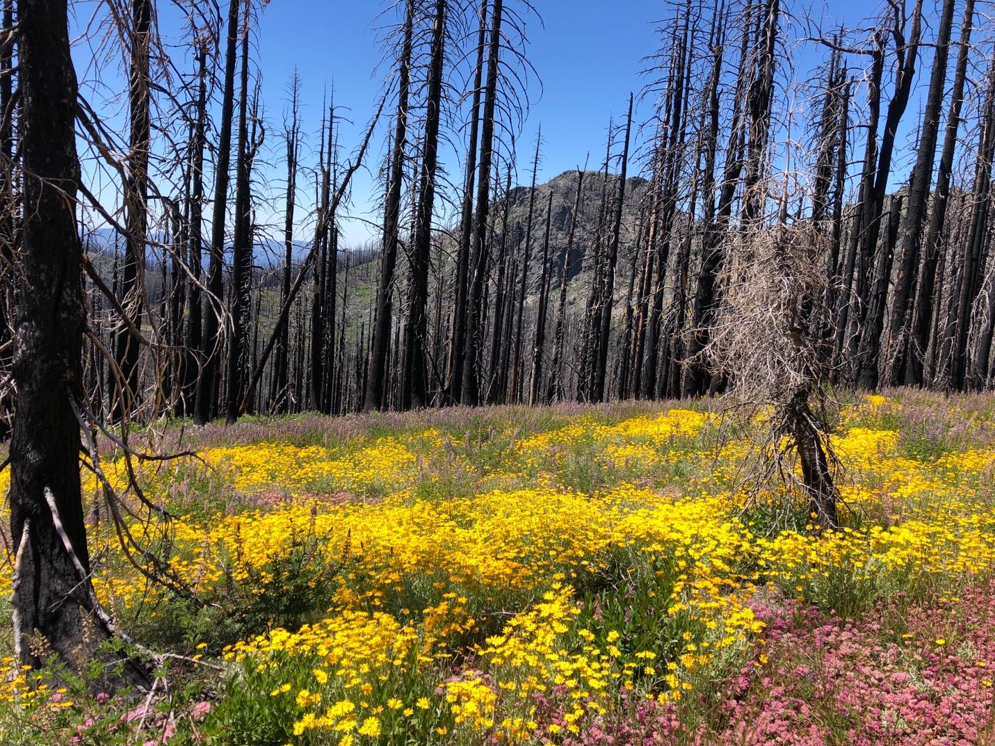
(a)
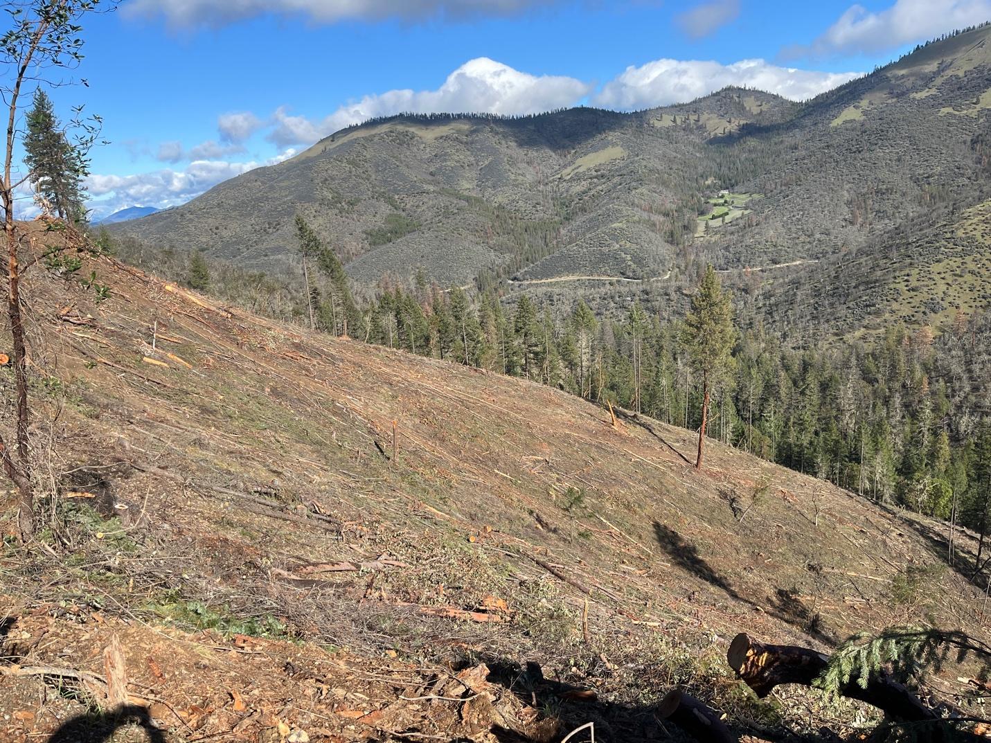
(b)
Figure 6. (a) Complex early seral forest with abundant biological legacies (e.g., snags) and fire-induced super blooms followed by the regeneration of woody shrubs and trees. This seral diverse and highly productive wildlife habitat is generated by a severe wildfire compared to (b) a clearcut in the Lickety Split Timber Sale logged in the winter/spring of 2024 by the Bureau of Land Management (BLM). The area lacks biological legacies and overstory canopy, and will fill in with dense regenerating, even-aged shrubs and trees that along with logging slash and fine fuels increase fire risks and reduce overall fire and climate resilience (L. Ruediger).
Importantly, early seral forests generated by clearcut logging practices – including post-disturbance “salvage” – differ greatly from CESF as the former degraded area is missing most if not all biological legacies (e.g., live and dead trees, logs, surviving shrubs and native seed banks). Table 1 is a comparison of the two different seral conditions (nature created vs. logging created) based on DellaSala et al. 2014. There are many examples of both these degraded logged conditions throughout the SCS.
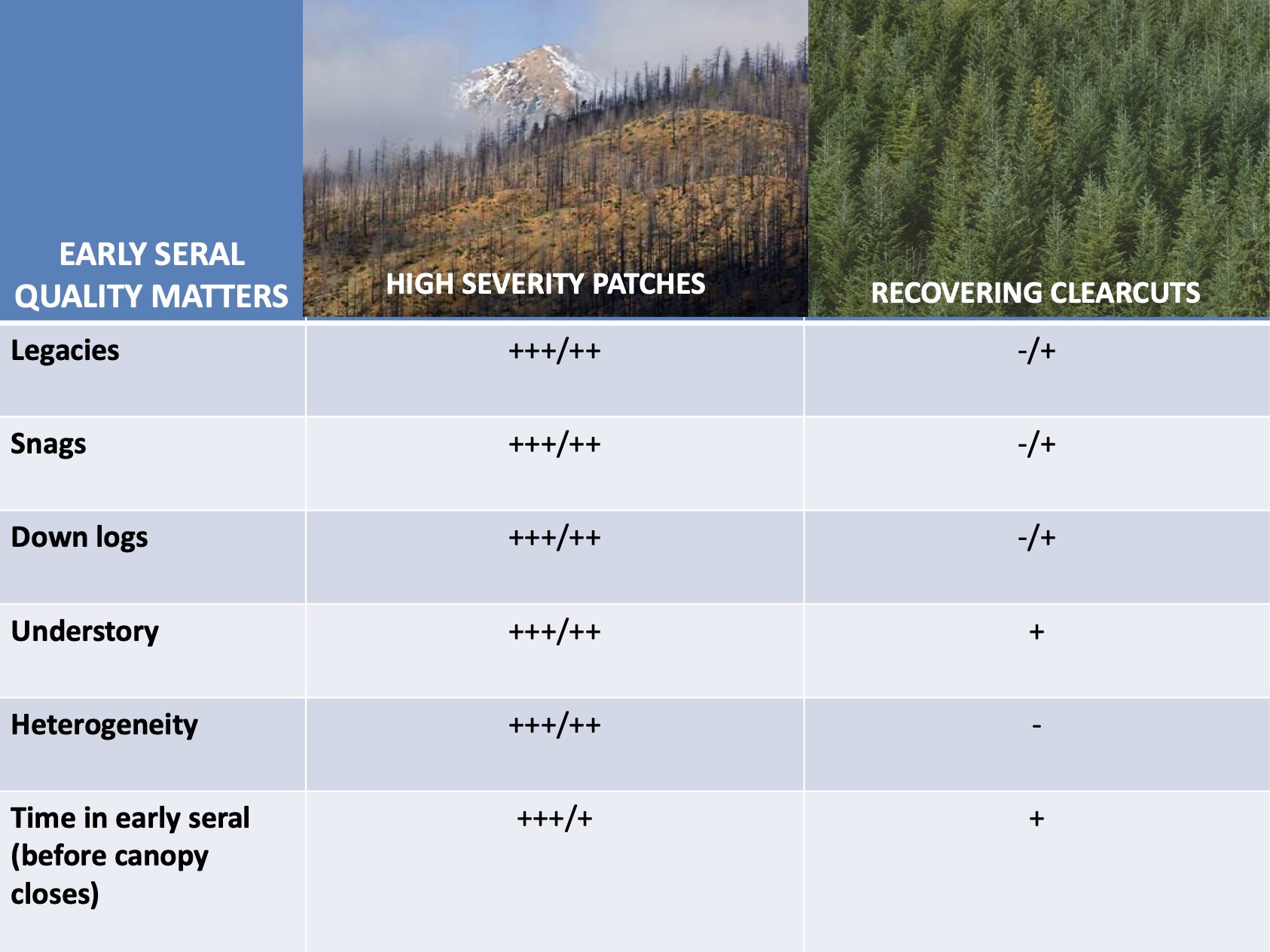
Table 1. Unlogged high severity burn-patches – complex early seral forests – vs. early seral clearcuts. Note, the +/- signs are relative abundances of the various forest quality indicators compared.
Plants
(Provided by botanist Julie Kierstead as summarized by Suzie Savoie)
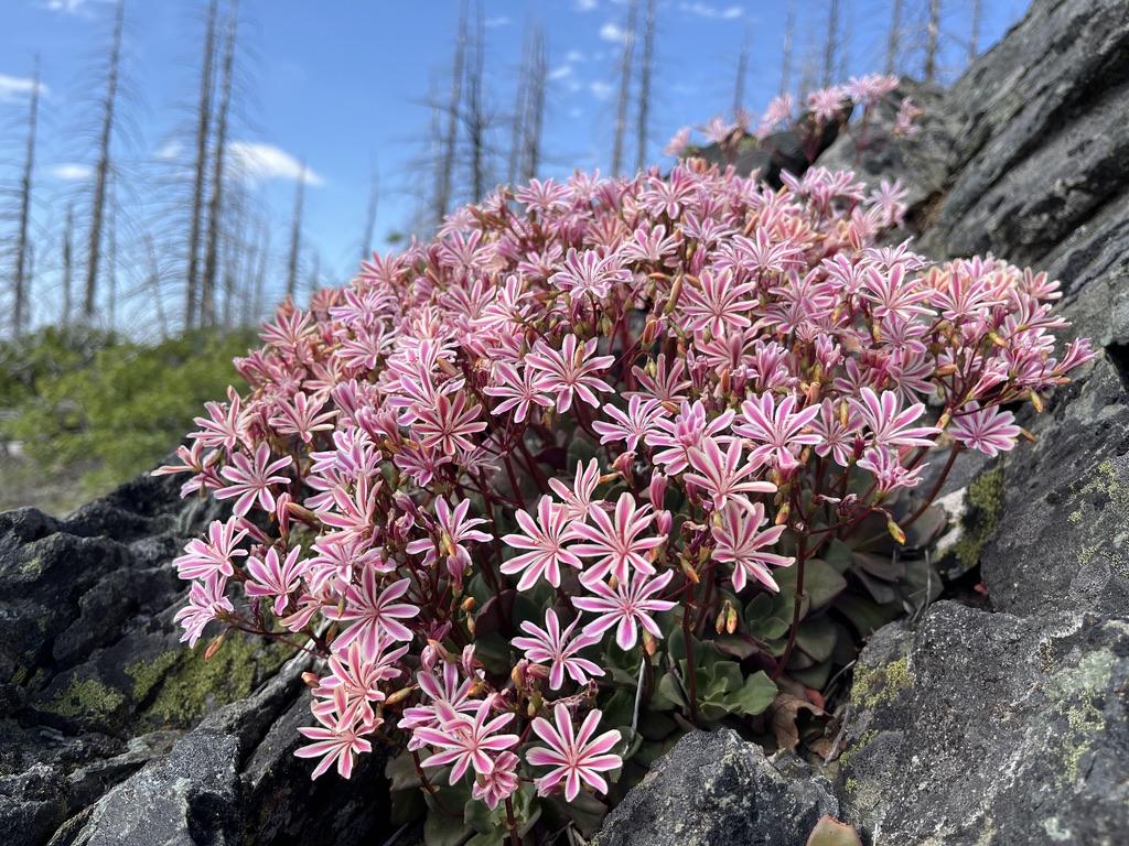
Siskiyou lewisia (Lewisia cotyledon), a Klamath-Siskiyou endemic blooming in the Condrey Mountain Inventoried Roadless Area (L. Ruediger).
The Siskiyou Crest Vascular Plant List is a botanical species list of vascular plants of the region that was compiled by botanist Julie Kierstead in 2026 (Appendix A). The result is the first comprehensive species list for the Siskiyou Crest region and demonstrates the extraordinary botanical diversity of the region, including 1683 distinct taxonomic entities — species, varieties, or subspecies.
Plant lists started with extracts done by staff of the Oregon Flora Project and Calflora, since the Siskiyou Crest polygon spans the border between Oregon and California and there is no professional grade database of vascular plant occurrences spanning both states. Calflora and Oregonflora are the two botanical authorities for the Siskiyou Crest region. Non-native taxa names were filtered out; the list here in Appendix A is native plants only.
Oregon Flora Project and the Jepson eflora of California (UC Berkeley) use different scientific names for the same plant taxa in some cases, so the synonyms were reconciled by checking each plant name in both the Jepson online eflora (the second edition of the print version has been revised 14 times already, so the eflora is the best currently accurate resource https://ucjeps.berkeley.edu/eflora/and OregonFlora online https://oregonflora.org/.
Each name was also checked against the maps of each plant’s records in JEPS and OFP. The JEPS distribution maps are based strictly on herbarium specimens, while the maps on Oregonflora include both herbarium specimens and some observations that are not vouchered.
Some plant names were removed from the original list if there were only one or two records and there was reason to doubt the accuracy of their locations or their ID. The rare plant status columns were filled using information from these sources:
For California, the California Natural Diversity Database Special Vascular Plants, Lichens, and Bryophytes list, April 2026; this includes California Rare Plant Ranks from the California Native Plant Society Rare Plant Inventory, sensitive species ranks from the Bureau of Land Management and US Forest Service in California, and listing status under the federal Endangered Species Act.
For Oregon, the Oregon Biodiversity Information Center Rare, Threatened, and Endangered Vascular Plant Species of Oregon (2023), which includes BLM and Forest Service sensitive species ranks for Oregon, and federal listing status under ESA, and the ORBIC rank of 1-4, which is like the California Rare Plant Rank.
This is a living list and will need to be continuously revised to reflect current research, information, and name changes.
Conifers
(Provided by Michael Kauffman as reflected, in part, in Conifer Country and The Klamath Mountains: A Natural History)
The Siskiyou Crest is recognized as one of the worlds’ foremost hotspots of temperate conifer diversity, where an exceptional concentration of species reflects millions of years of geological complexity, climatic stability, and evolutionary persistence. Within a relatively small geographic area, some 27 native conifer species (Appendix B provided by Luke Ruediger of the Siskiyou Crest Coalition) are distributed across steep elevational gradients, precipitation, and substrate, creating an unparalleled overlap of coastal, montane, and interior forest communities. This diversity is further distinguished by the presence of four exceptionally rare conifers that define the crest’s botanical significance. Pacific silver fir (Abies amabilis) and yellow-cedar (Callitropsis nootkatensis) reach the southernmost extent of their North American distributions here, while Brewer spruce, Baker’s Cypress, and Port Orford-cedar are Klamath Mountain endemics whose global distributions are centered on the Siskiyou region.
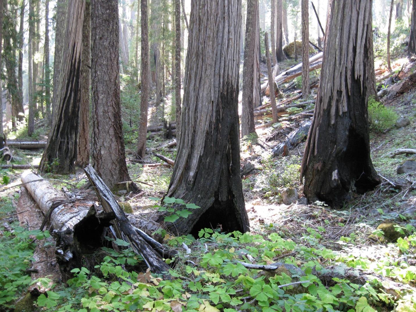
Fire-adapted old-growth Port Orford cedar (Chamaecyparis lawsoniana) on the East Fork Illinois River and in the Siskiyou Inventoried Roadless Area adjacent to the Siskiyou Wilderness Area (Photo: L. Ruediger).
The coexistence of northern relicts and regional endemics within the same mountain landscape is unmatched elsewhere in North America and underscores the importance of the SCS as both a refuge and a center of conifer biodiversity.
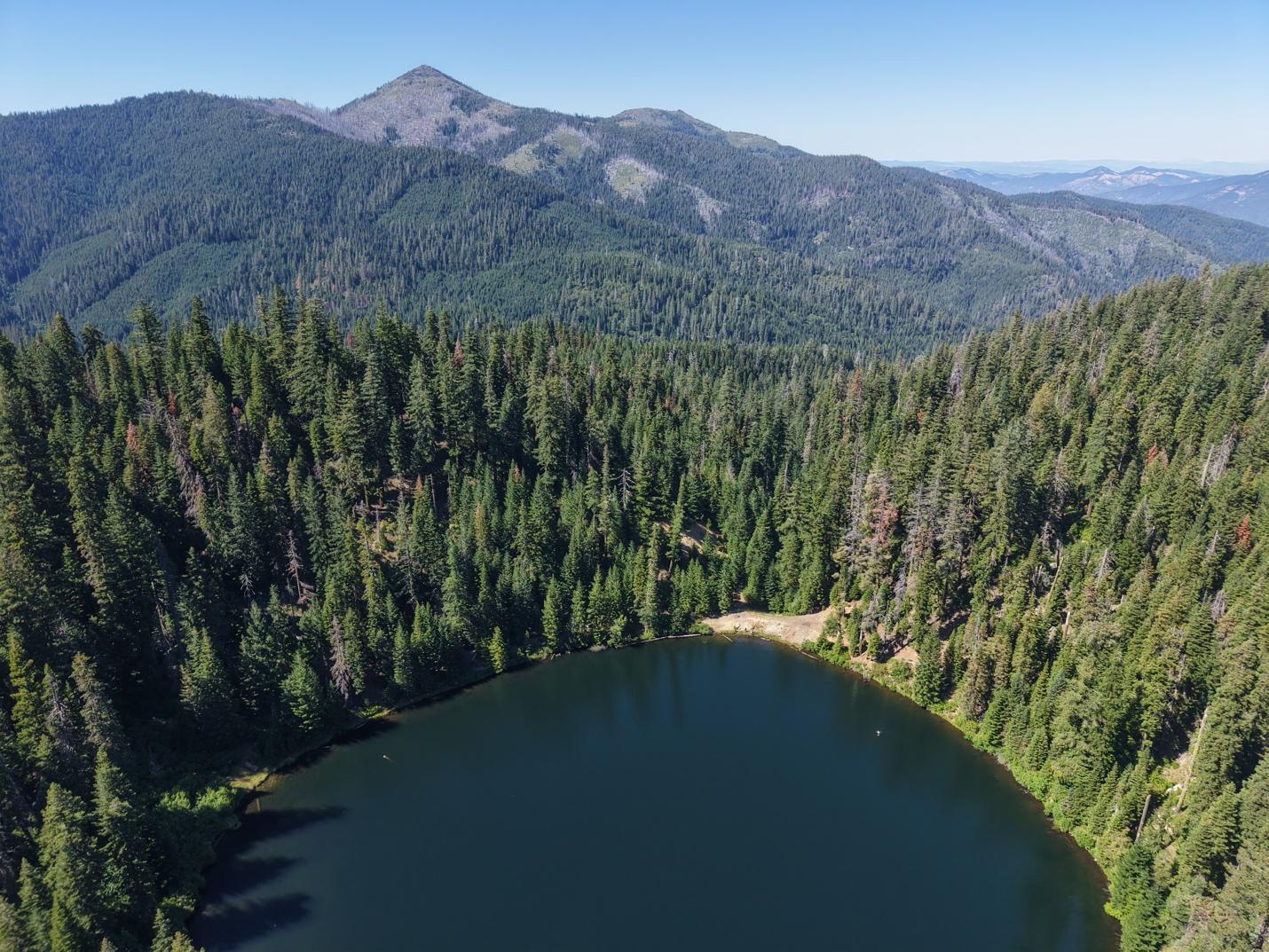
Miller Lake in the Kangaroo Inventoried Roadless Area contains a Baker cypress grove adjacent to the lake in the Oliver Matthews Research Natural Area (Photo: Applegate Siskiyou Alliance)
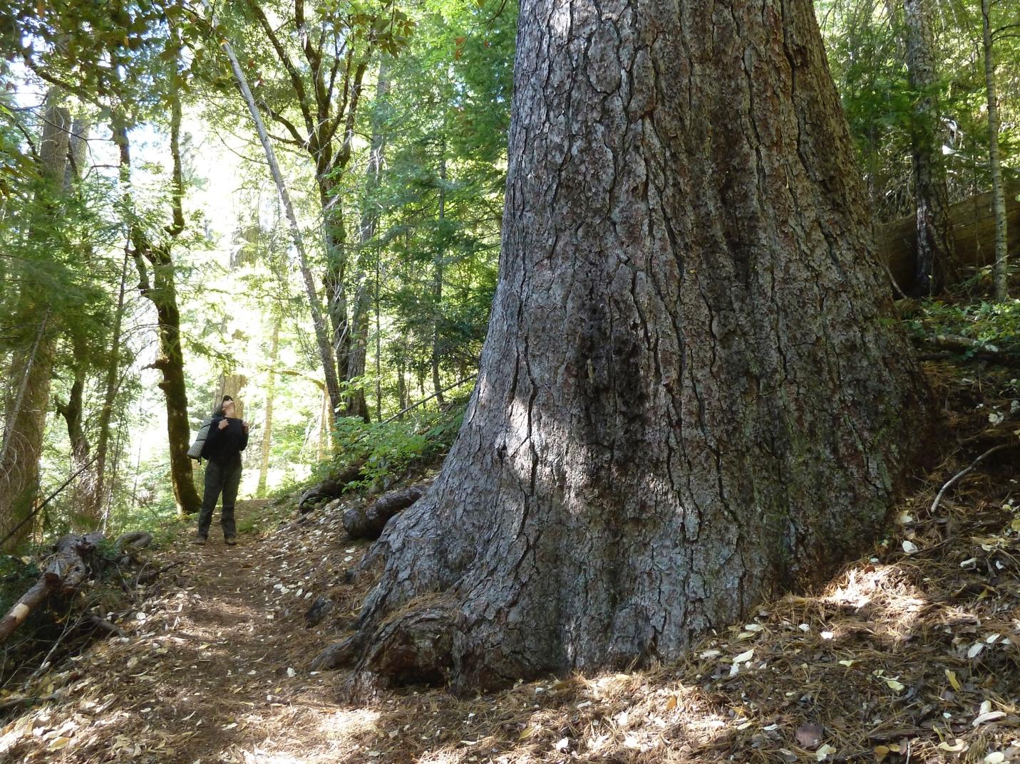
Old-growth sugar pine on the Butte Fork Applegate River in the Red Buttes Wilderness Area (L. Ruediger)
Bees
(Provided by entomologist, Lincoln Best, Oregon State University)
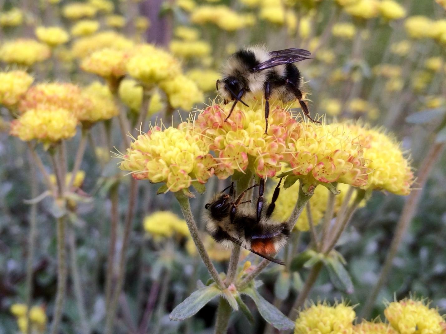
Black-tailed bumble bee on sulphur flower buckwheat, Siskiyou Crest Subregion (Photo: Applegate Siskiyou Alliance).
The Oregon Bee Atlas (Oregon State University) with Master Melittologist (OSU Extension Service) volunteers have documented more than 18,000 bees among nearly 400 species visiting 282 flowering plant genera (Melittoflora.org; dataset V3 – February 17, 2026) within the KSE. Many of these species are specialist pollen collectors of native plant hosts, some of which are at the northern extent of their range within the Oregon section of the California floristic province. Of special note is Franklin’s bumble bee, Bombus franklini, an endangered species with the smallest known distribution among bumble bees in the world. Most of its historical range is within the KSE, and it has not been documented since 2006 despite extensive search effort. Crotch’s bumble bee (Bombus crotchii) also has the northern extent of its distribution in the SCS having been recently discovered in Oregon on top of Mt. Ashland (Watts et al, 2026). Other smaller, and lesser-known species such as Hoplitis emarginata, the Stonecrop specialist bee, have much of their global range in the SCS.
The Stonecrop bee collects pollen from our native succulent, Sedum oregonense, in alpine rock gardens throughout the Siskiyous and adjacent mountains. The SCS contains high species richness of wild bees that parallels the high richness and endemism of wild plant species. From low and mid-elevation vernal pools to rocky alpine outcroppings, specialist pollen foraging bees maintain an intimate association with the SCS flora. Continued study in the area will result in many new species, refined distributional data, and importantly, floral associations. Additional species occurrence data from the Oregon Bee Atlas can be found at the Global Biodiversity Information Facility (Best 2026).
Butterflies
(Provided by Luke Ruediger)
Notably, the Cascade-Siskiyou National Monument (adjacent and east of the SCS) is one of the most butterfly rich places in western North America that has received much scientific and conservation attention. Here, we summarize recent and published survey data on the butterfly richness of the SCS specifically. Of significance thus far is the total number of butterfly species from four areas within the SCS to date is 110 (Appendix C).
Butterfly source data was obtained from three sources: North American Butterfly Association’s (NABA) Siskiyou Crest Count from 2018-2026; Butterflies of the Bigelow Lakes Basin: 2014 Surveys prepared by entomologist Dana Ross, for the Oregon Caves National Monument; and iNaturalist (iNat) Research Grade observations from 2012 – 2026. An asterisk after scientific name in the table indicates the species is listed only under iNat observations.
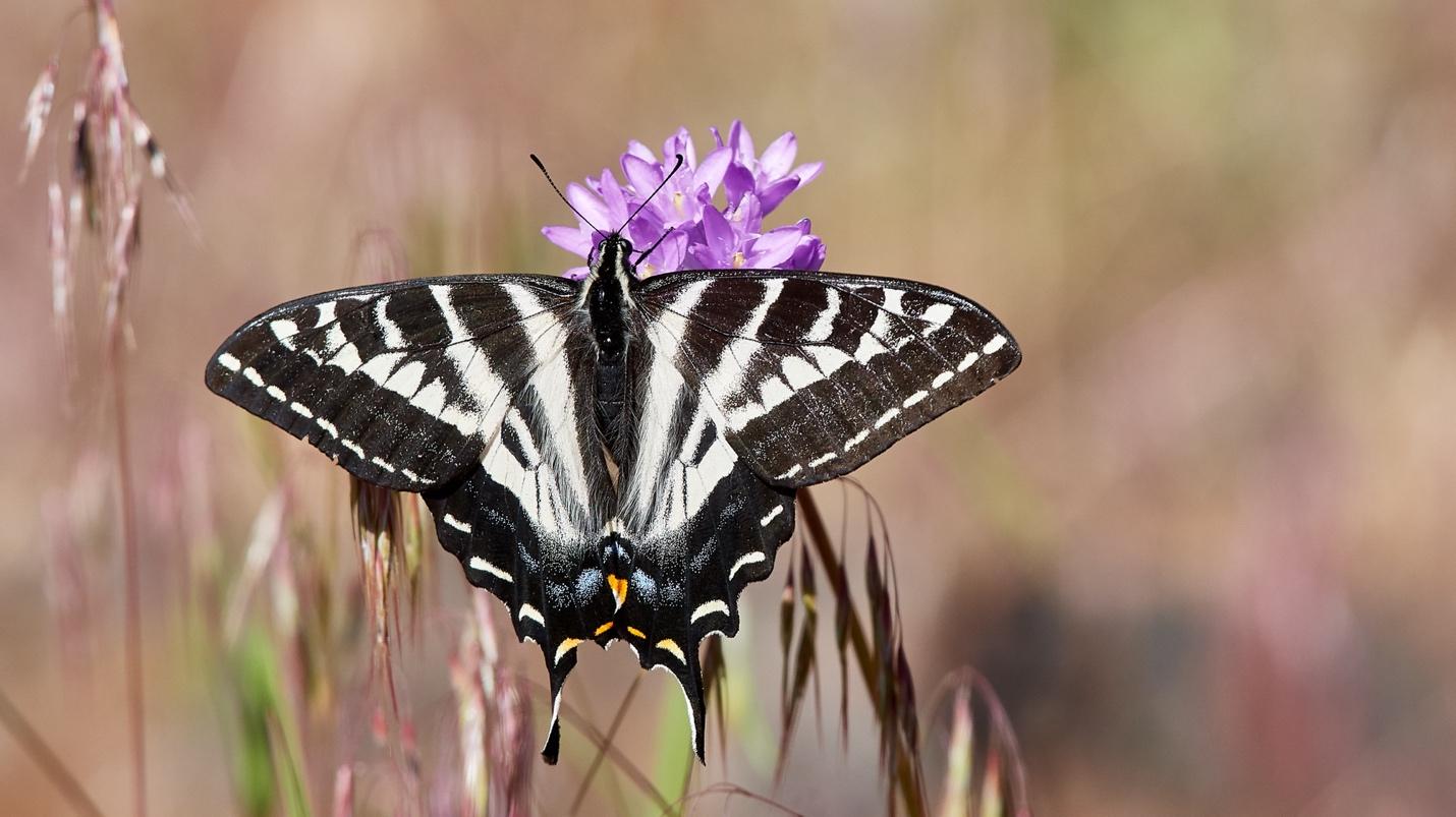
Photo: pale tiger swallowtail (Photo: F. Lospalluto)
North American Butterfly Association Count
The NABA count data was collected annually within the second week of July by Dianne Keller and other volunteers. Pre-count and post-count informal excursions resulted in additional early and late season species included. The Siskiyou Crest NABA count circle extends from Mt. Ashland on its east side to Dutchman Peak/Observation Peak areas on the west with the circle center at Big Red Mountain where the PCT crosses NF20 Road.
The NABA butterfly count involves volunteers counting butterflies within a designated 15-mile diameter circle, where they are organized into teams led by experienced counters. Each team surveys various sites in the circle and records all butterfly observations during the count day. Butterflies were identified by sight, catch and release, and photographs.
Bigelow Lakes Basin
Dana Ross and Linda Kappen conducted 4 one day visits during June and July 2014 along a prescribed route in the Bigelow Lakes basin. Surveys were conducted on sunny or mostly sunny days with an air temperature above 60 degrees. Butterflies were identified by sight and by catch and release. Taxonomy follows that of the butterfliesofamerica.com website. Voucher specimens were collected and deposited in the collections of Oregon Caves National Monument and Oregon State University Arthropod Collection.
iNaturalist Observations
The iNaturalist species list was generated by downloading butterfly observations using the following query filters: species = Papilionoidea, life_stage=adult, place = Siskiyou Crest Region (an iNat place created by Dianne Keller from the Siskiyou Crest area kml file supplied by Luke Ruediger), identifications = any, and quality grade = research. To achieve Research Grade an observation needs to go through the iNat data quality assessment process satisfying all the criteria of accuracy, precision, completeness, relevance, etc.
Moths
(Prepared by Dana Ross and Edited by Suzie Savoie)
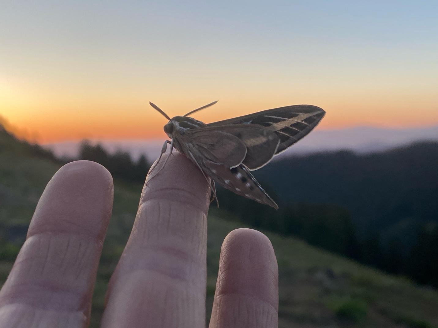
White-line sphinx moth, Siskiyou Crest Subregion (Photo: Suzie Savoie)
The Siskiyou Crest Moth Project (SCMP) is setting out to identify the moth species that live, reproduce, and/or migrate through the Siskiyou Crest Subregion. This ambitious multi-year project is part way through its first sampling season and currently has seven study sites (see below). Study sites vary from low elevation chaparral, oak woodland, mixed conifer and riparian areas to high elevation ridgelines, meadows and subalpine forests, and serpentine, as well as the footprint of a recent wildfire.
Moths are an understudied in the Siskiyou Crest Subregion, and SCMP is working to make the documentation of the moth fauna on par with that of other, more well-known insects and pollinators, such as bees and butterflies.The SCMP is in the process of creating a moth species list for the Siskiyou Crest region, along with geospatial data for the moth collections. Through July 2026, the SCMP has positively identified 417 species of moths (Appendix D).
Representative moth voucher specimens will be added to the Oregon State Arthropod Collection at Oregon State University, and the findings are slated to be detailed in a scientific paper that will result from this long-term study.
Notably, North America is home to 12,000+ species of moths, compared to only 800+ species of butterflies; in fact, butterflies evolved from moth ancestors and are really a day-active group of moths. Moth experts suspect that there are likely over 1000 species of moths that call the Siskiyou Crest home.
The SCMP will look for endemic moth species, such as the Siskiyou hadena moth (Hadena siskiyou), whose range is primarily restricted to the Siskiyou Mountains. The SCMP expects to unveil new discoveries that highlight just how much we have yet to learn about the countless species of moths that call the Siskiyou Crest home.
To accomplish this undertaken, SCMP utilizes community science, with the help of potentially hundreds of volunteers over several years, that will increase the capacity of the project and the amount of moth samples and observations. Moth nights at the various SCMP study sites have been open to the public at various times of the year for volunteers and local community members to help contribute to science. Volunteers utilize a moth sampling method that lures moths to a sheet with black lights. Moths are then captured individually as samples in glass or plastic vials for identification and ultimate inclusion into the Oregon State Arthropod Collection.
Many moths require close inspection of wing patterns or genitalia for certain identification. Once pinned, labeled and deposited into a museum collection, vouchers serve as both a physical record for the study and become available to researchers for additional studies. This project will be an ongoing, multi-year effort to document moth species in the Siskiyou Crest region.
Notably, through July 2026, the project hosted 34 moth nights with 136 volunteer mothing shifts.
Total moth species identified through July at each 2026 SCMP study site:
- Colestin Valley – 125 species
- Mt. Ashland – 205 species
- Observation Peak – 156 species
- Humbug Creek – 169 species
- Elliott Creek – 172 species
- Oregon Caves – 62 species
- Takilma – 156 species
The SCMP plans to sample up to six new study sites in 2027, as funding allows.
Amphibians
(Provided by herpetologist Gwen and Bruce Bury)
The KSE includes at least 27 amphibian species, which is the most of any mountain range in the Pacific Northwest (Bury and Pearl 1999; Kaufmann and Garwood. 2024). The high diversity of the KSE reflects a zone of transition from northern amphibians (adapted to wet, cool forest) to those adapted to conditions to the south (more dry, warm habitats). Another factor which adds to the diversity of the KSE are six endemic species of lungless salamanders. Of these, the Siskiyou Mountain Salamander occurs on the slopes of the Siskiyou Crest with different genetic groups on the north and south sides. Another division is found at the Rogue River, where Western Red-backed Salamanders are only found to the north, and Del Norte salamanders are found to the south.
Besides the terrestrial amphibians, the cool streams of the KSE are home to three families considered endemic to the Pacific Northwest: Pacific Giant Salamanders, Torrent Salamanders and Tailed Frogs. These are all ancient lineages, and basal to large groups. In particular, the Tailed Frog is the most primitive of all frogs, and its nearest relative today lives in New Zealand. Timber harvest reduces Torrent Salamander and Tailed Frog populations, and some terrestrial salamanders. There is an urgent need for research on this topic, due to a lack of recent studies in the KSE region (especially the SCS), and the effects may be multiplied by compounding impacts such as fire and climate change.
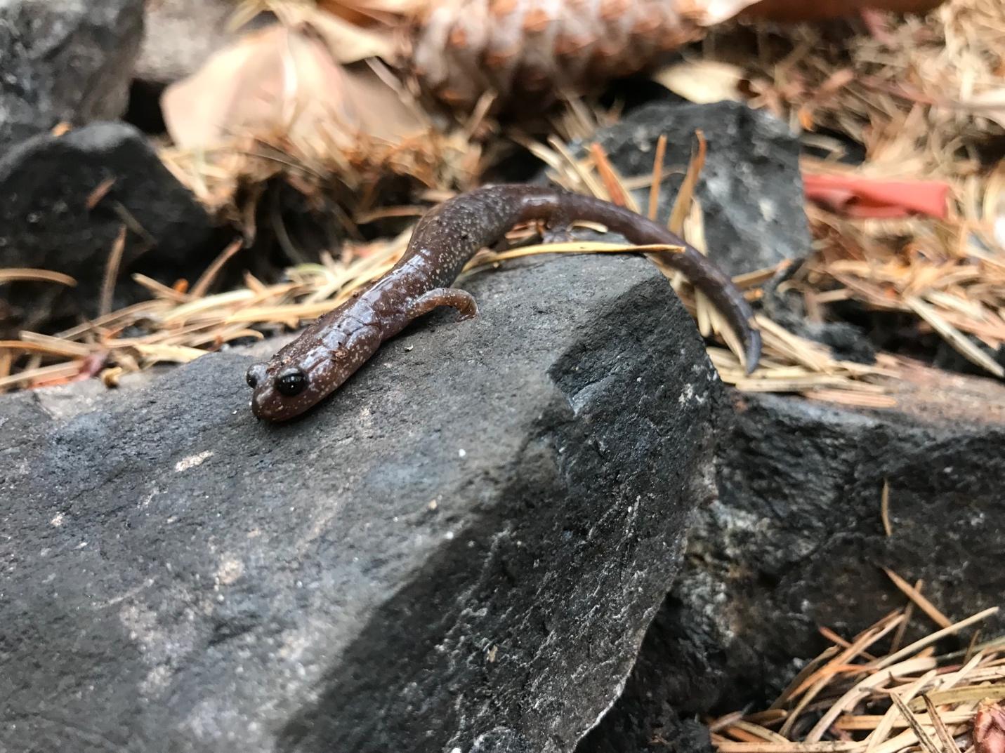
The Siskiyou Mountains salamander (Plethodon stormi) is a narrow Siskiyou Crest endemic found in moss covered talus slopes sheltered by mature, late successional or old-growth forests. This photo was taken after the mixed severity 2017 Abney Fire in the Kangaroo Inventoried Roadless Area where we found viable populations and significant reproduction in the burn area (Photo: L. Ruediger).
Importantly, the diverse amphibian fauna is not well protected. For example, two endemic species (Siskiyou Mountain and Scott Mountain Salamanders) were proposed for Federal threatened listing but found not warranted. Since then, large wildfires have occurred across their ranges, and their status has not been reassessed. Further complicating protecting species, several recent studies on genetic variation in the regional herpetofauna suggest several cryptic species (little or no visual differences); these species will be described in the future.
The mountains of the SCS, are potential refugia for amphibians, especially in the future as conditions warm from climate change. Unfortunately, range shifts (e.g., northward) are partly blocked by lower elevation xeric habitats. There are many other potential impacts to amphibians, which compound on each other, including: drought, fires, logging, mining and other human land and water use. The story of the diversity in herpetofauna is far from complete and is worth protecting.
Citations (no hyperlinks available)
Bury, R.B.; Pearl, C.A. 1999. Klamath-Siskiyou herpetofauna: Biogeographic patterns and conservation strategies. Natural Areas Journal 19, 341-350.
Kaufmann, M.; Garwood, J. 2024. The Klamath Mountains: A Natural History. Backcountry Press: Kneeland, California, USA. pp. 489.
Birds
(Provided by ornithologist, Pepper Trail and Frank Lospalluto using e-bird list)
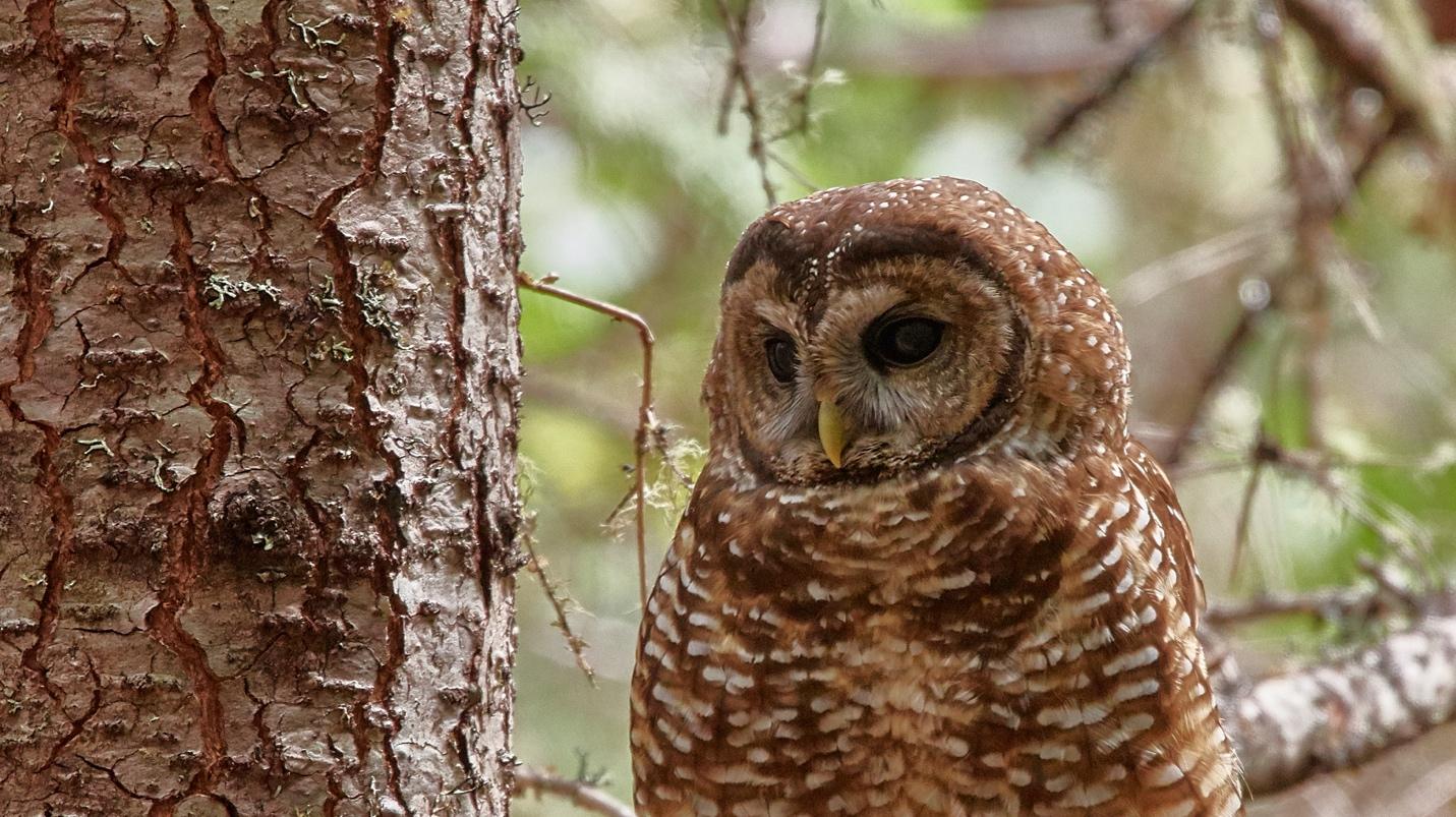
The northern spotted owl Photo: USFWS
The well-known importance of the KSE as a biogeographic crossroads is strongly confirmed by bird species distribution (Trail 1997). Notably, using e-bird, 173 bird species were identified in the SCS (Appendix E) as compiled by Dr. Frank Lospalluto.
In general, the SCS is home to related bird species typical of very different ecoregions; for example, both Spotted and Great Gray Owls; Allen’s and Calliope Hummingbirds; and California and Green-tailed Towhees. Several birds appear to be expanding their range limits northward, including Blue-gray Gnatcatcher and California Thrasher. All this makes the Siskiyou Crest an especially important region for monitoring range expansion and contraction in response to changing conditions, and for research on the factors limiting species distribution.
The SCS is also home to many birds of conservation concern, including more than 50 species of neotropical migrants (based on lists in Finch and Stangel 1992), 31 of the 38 old-growth associated species identified by the team of federal scientists who developed the Northwest Forest Plan (USDA/USDI 1994) and 16 species on the Oregon Dept. of Fish & Wildlife’s “Sensitive List” (ODFW 2021). Preservation of the region’s avian populations and habitats is of critical importance to any overall effort to protect the avian biodiversity of the United States.
Most notably, the Crest is home to the federally threatened Northern Spotted Owl (NSO) that nests in old-growth forests and hunts for prey in severely burned forest patches (Franklin et al. 2000, Lee et al. 2018). Spotted owls have been experiencing range-wide decline most notably because of habitat destruction caused by logging and competition with the invasive Barred Owl. Logging before and after severe wildfires in spotted owl territories in combination with encroachment by Barred Owls are key drivers of spotted owl decline (Bond et al. 2022).
Citations (no hyperlinks)
Trail, P. W., R. Cooper, and D. Vroman. 1997. The breeding birds of the Klamath/Siskiyou region. Pp. 158–174. Proceedings of the First Conference on Siskiyou Ecology. Siskiyou Project and Nature Conservancy, Cave Junction, OR.
Trail, P.W. 2004. Population trends among landbirds of the Klamath-Siskiyou Ecoregion: an analysis of Breeding Bird Survey data. Pp. 47-59 in Proceedings of the Second Conference on Klamath-Siskiyou Ecology (Mergenthaler, K.L., et al. eds.). Siskiyou Field Institute, Cave Junction, OR.
Mammals (Pacific Fisher focal species) (Prepared by DellaSala)
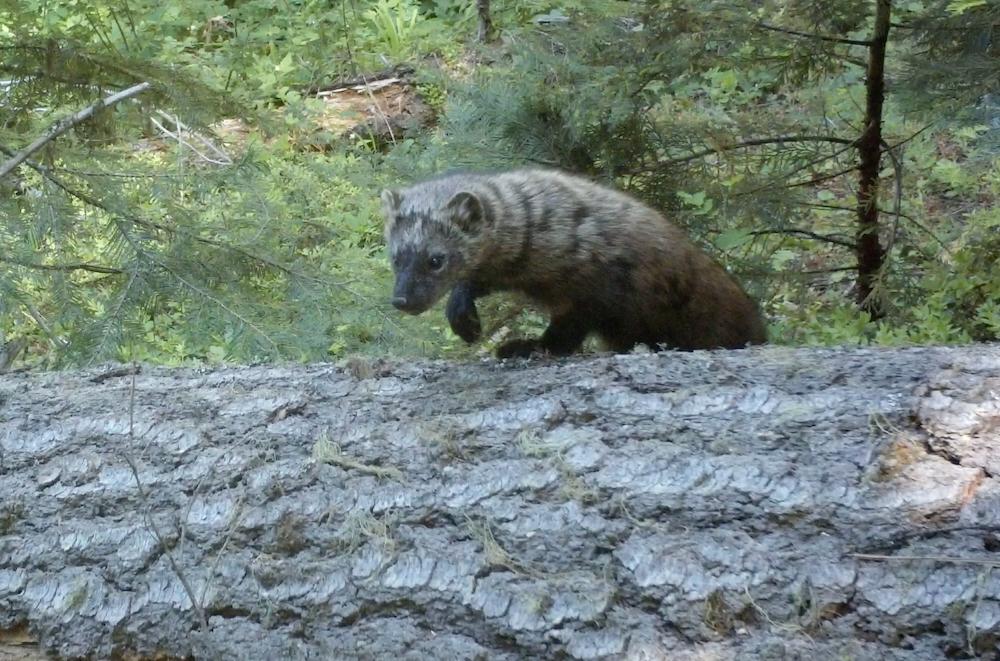
A Pacific fisher utilizing a large, downed log in old-growth forest at the headwaters of the Little Applegate River and directly adjacent to the McDonald Peak Inventoried Roadless Area (Photo: L.. Ruediger).
There ostensibly have been no recently published mammal surveys in the SCS. Earlier studies of northwestern California and southwest Oregon provide species accounts typical of the vegetation communities in the SCS (Ralph et al. 1991, Raphael 1988). Importantly, the SCS is home to the Pacific Fisher that dens in old-growth forests and can hunt for prey in severely burned patches as documented for fisher populations in the Sierra range (Hanson et al. 2013). These medium-size mammals (meso-carnivores) are in the same family as weasels, mink, marten, and otters (https://www.fws.gov/species/fisher-pekania-pennanti). Fisher utilize forests with dense tree cover and large old trees. Notably, the species was extirpated from most of its historic range in the Pacific Northwest with reintroductions in California and Washington and translocation of populations into Oregon. Interestingly, fishers in Oregon are restricted to two disjunct and genetically isolated populations in the southern Cascade Range and the northern Siskiyou Mountains (Aubry and Lewis 2003). Populations of fisher in the KSE – which includes the SCS – are of major importance as it represents the largest native fisher population in the western USA (Slauson and Zielinski 2004). Because the fisher hunts and disperses over large areas it was used as a focal species for connectivity in the ECA (DellaSala et al. 2026).
Citations (no hyperlinks)
Raphael, M.G., 1988. Northwestern California¹. In Management of Amphibians, Reptiles, and Small Mammals in North America: Proceedings of the Symposium, July 19-21, 1988, Flagstaff, Arizona (Vol. 166, p. 23).
Ralph, C.J., Paton, P.W. and Taylor, C.A., 1991. Habitat association patterns of breeding birds and small mammals in Douglas-fir/hardwood stands in northwestern California and southwestern Oregon. Pages 379-393 in Ruggerio, LF; Aubry, KB; Carey, AB; Huff, M., eds., Wildlife and Vegetation of Unmanaged Douglas-fir Forests. Portland, OR: US Department of Agriculture, Forest Service, Pacific Northwest Research Station. Gen. Tech. Rep. PNW-GTR-285.
Aquatic Species Richness
(Provided by D. DellaSala)
The KSE is known to have continentally significant levels of aquatic biodiversity (Abell et al. 2000) and aquatic snails are exceptionally diverse (see DellaSala et al. 1999 for early inventories by Terry Frest and Edward Johannes). Most notably, the KSE is home to several salmonid species, including chinook, coho, steelhead, coastal cutthroat trout, and red band trout along with at least 4 species of lamprey. However, differences between the ecoregion and subregion are not well known due to a lack of crest-specific inventories.
Importantly, there are 35 HUC8 watersheds (subbasins) in the KSE and 7 in the SCS (Applegate, Illinois, Lower Klamath, Middle Rogue, Scott, Smith, Upper Klamath). Only one of the 7 HUC8 watersheds in the SCS met a conservation target of at least 30% protection – the Smith HUC 8 that flows to the coast.
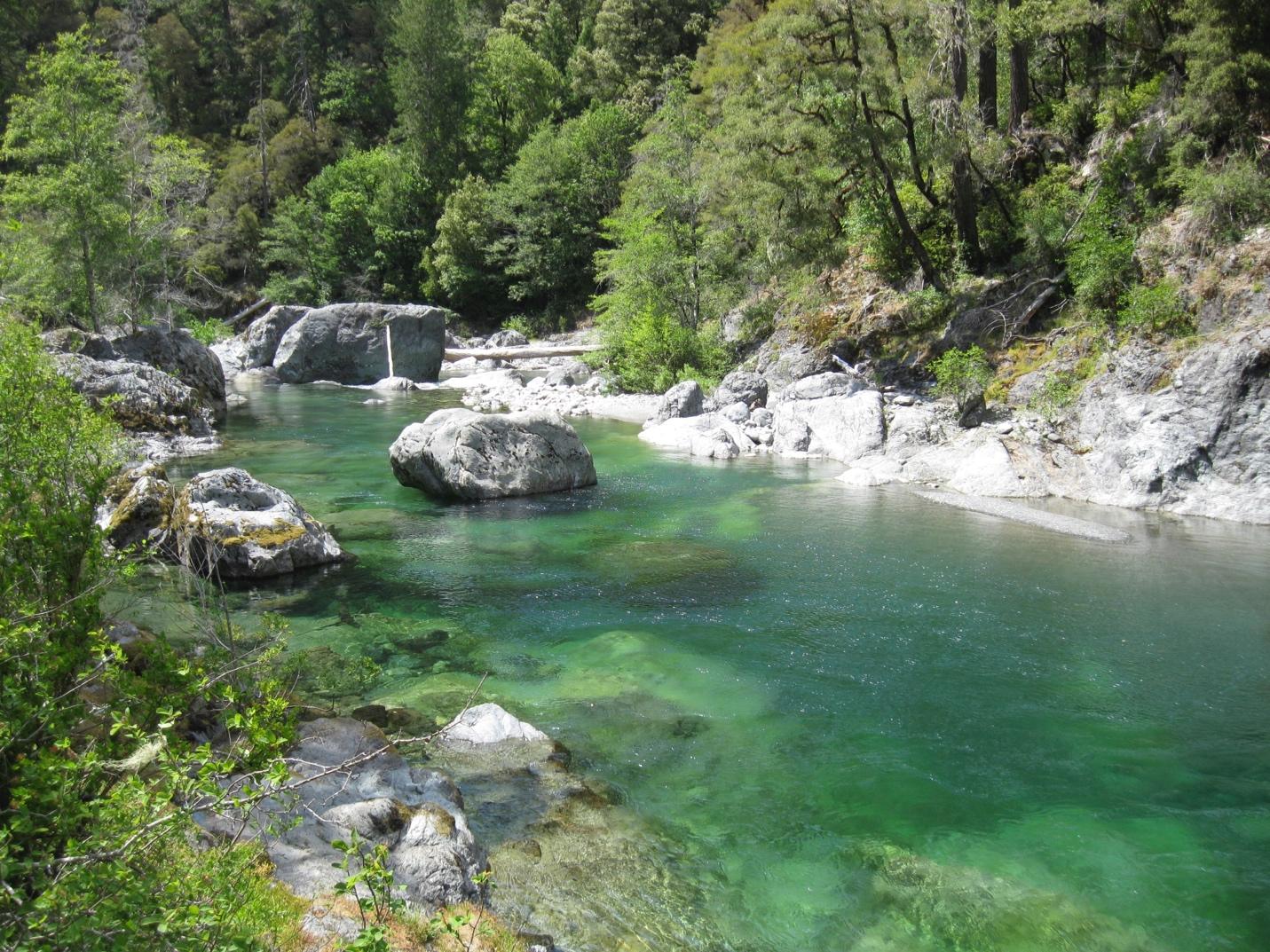
The South Fork of the Smith River flows from its headwaters in the Siskiyou Wilderness into the Smith River National Recreation Area at the western portion of the Siskiyou Crest Subregion (Photo: L. Ruediger)
Climate Change
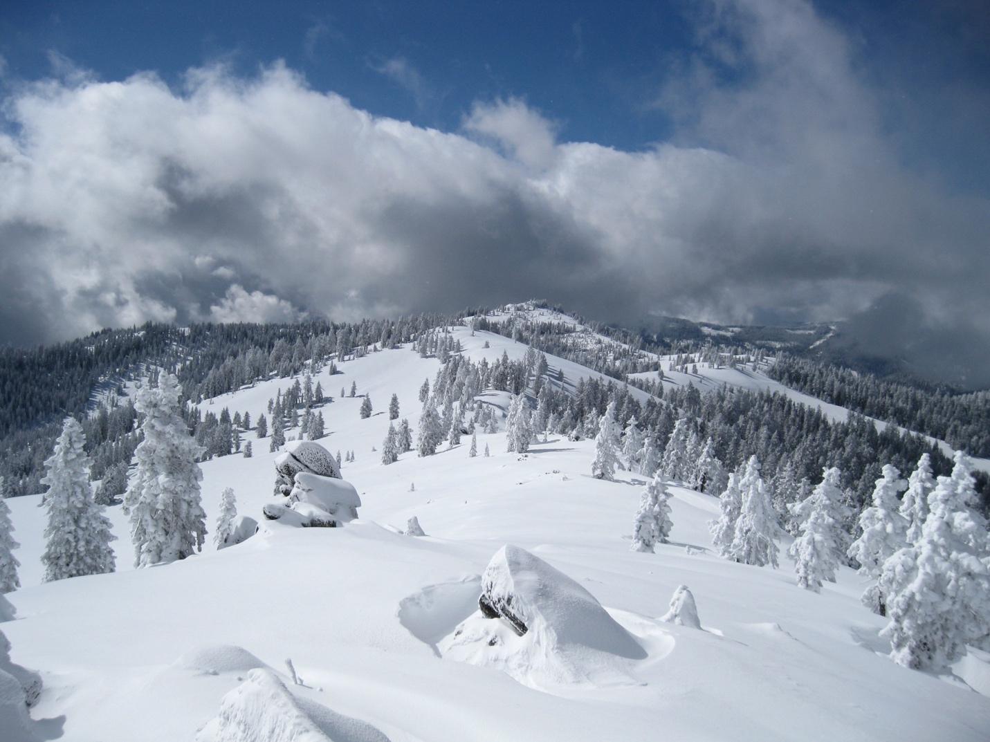
Downscaled climate models and historical records show a reduction in snowpack in the Siskiyou Crest region, including landscapes like the McDonald Peak Inventoried Roadless Area that contain some of the range’s highest elevation habitat (Photo: L. Ruediger)
The Earth’s climate has changed numerous times over millions of years. However, the recent changes (increasingly noticeable since the 1980s) are due primarily to human activities – the burning of fossil fuels and land-uses like logging plus other human activities. Effects are being felt planet-wide evident by melting glaciers, intense storms, increasing wildfires, heat-induced human morbidities, droughts, floods, atmospheric rivers – “rain-bombs” – and sea level rise, to name a few. What happens to the SCS, and it’s presumed refugium properties will be determined in the coming decades based on global emissions and land-uses (E.G. logging, roads, mining). The KSE and SCS are both experiencing notable increases in summer-time temperatures, less snowfall, more droughts, and more wildfires. The 2020 “heat dome” over Oregon had a reverberating effect on tree mortality most evident at lower elevations, on xeric sites, and in interior habitats within the SCS and adjacent portions of the KSE where significant tree die-offs are underway. These stressors are amplified by logging that degrades habitat for insectivorous species that otherwise can serve as “checks and balances” on insect outbreaks.
Importantly, refugia properties of the SCS will only persist if global emissions are substantially lowered and priority areas identified by the ECA (DellaSala et al. 2026) and by local conservation groups are protected from logging. In contrast, with increasing emissions and land development stressors, refugia properties that include high elevation areas, older forests, intact watersheds, and forests on cooler, north-facing slopes will begin to break down. A consequence of these combined actions (emission and logging increases) is that over 10% of the rich taxa in the KSE may be extirpated (Olson et al. 2012). That would potentially amount to thousands of species in the coming decades without stepped up conservation.
About Ecoregional Conservation Assessments (ECA)
Ecoregions are large areas consisting of similar landform features (geological history), broad vegetation types (e.g., land cover types), and consistent climatic processes that drive species assemblages and disturbance ecology. ECAs have been used in conservation planning for decades to determine, for instance, if there is sufficient protection of priority areas in conservation reserves. More recently, ECAs have included information on climate change projections (i.e., “climate downscaling”) useful in preparing people and nature for a rapidly changing climate.
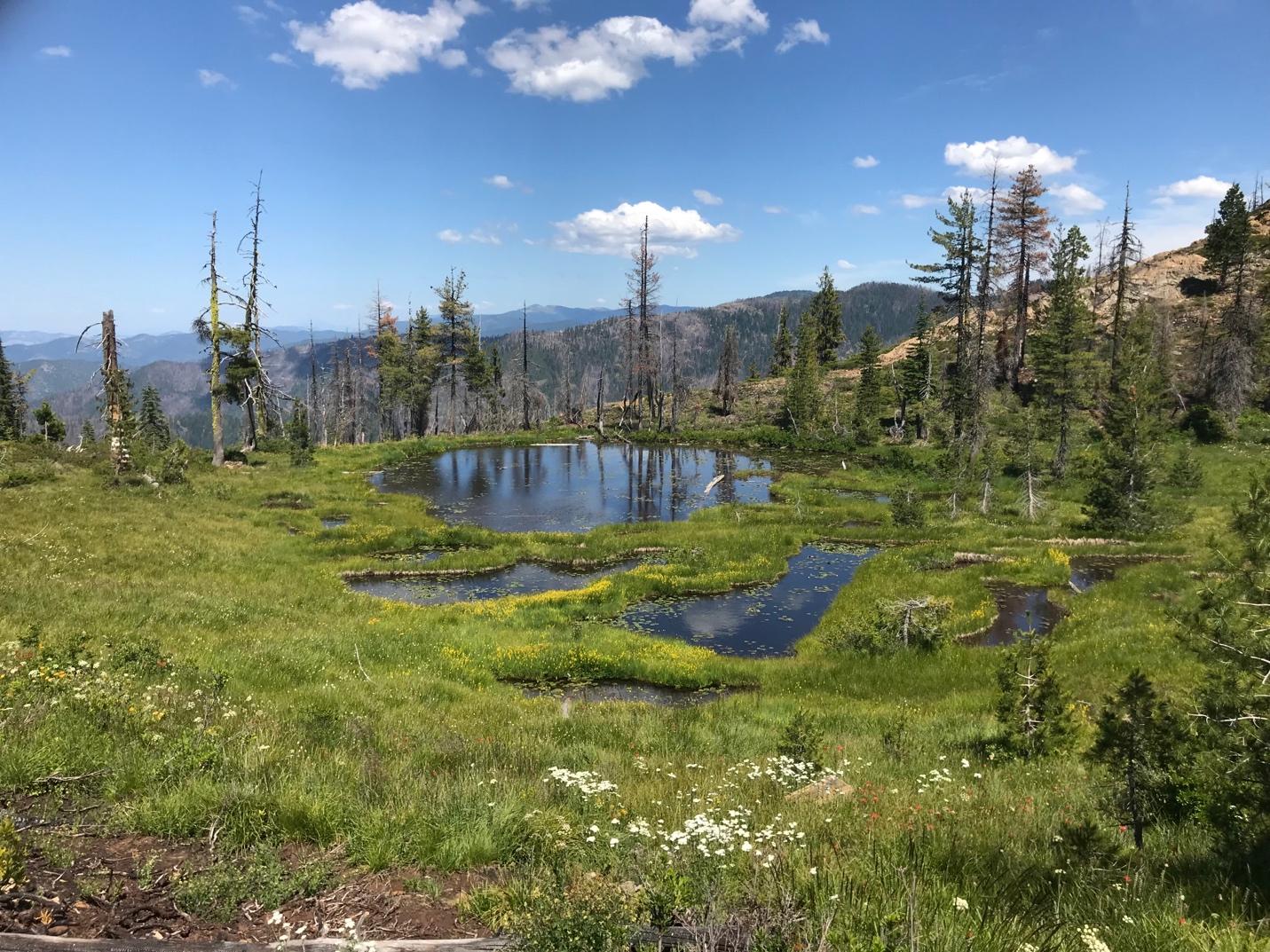
Serpentine wetlands and wet meadows at the headwaters of Cook and Green Creek in the Kangaroo Inventoried Roadless Area (Photo: L. Ruediger).
This is the fourth in a series of published ECAs that include the Mogollon Highlands (AZ, NM) (DellaSala et al. 2023); the Southern Rockies (WY-NM) (DellaSala et al. 2024); and the Northern Rockies (MT) (DellaSala et al. 2025); a fifth is under development for the Eastern Cascades and Blue Mountains of Oregon. ECAs also redirect wildfire risk reduction treatments to community protection at the structure itself instead of back country logging that is amplifying extreme wildfire effects (Zald and Dunn 2018). ECAs make possible new forest protection proposals that are responsive to effective community protection from wildfires.
Scientists involved in the this ECA used several published datasets and Geographic Information Systems (GIS) in computer mapping approaches to assess conservation priorities at both spatial scales (KSE, SCS). The ECA process was developed over a two-year period that began with an expert’s workshop to establish project objectives and priorities. DellaSala et al. (2026) published the main findings in the peer-reviewed journal, Diversity. This ECA summarily included 11 Figures and 8 Tables in the main body of the text and an additional 14 Figures and 8 Tables in the online supplemental. Climate change projections made up the bulk of the analysis and determine how the KSE and SCS might change over time, and what areas may function as refugia. Additionally, extensive ecoregional representation analyses were used to determine whether conservation targets such as 30% protected by 2030 (30 x 30), 50% protected by 2050 (50 x 50), and 100% protected (no timeline) were met for select land cover types and habitats such as old forests and focal species habitat (e.g., Pacific Fisher, Northern Spotted Owl).
Key Findings of the KSE/SCS Ecoregional Conservation Assessment:
- The percentage of protection falls far short of conservation targets with only 15% and 14.5% of the KSE and SCS, respectively, protected in parks and wilderness areas.
- Protected areas are skewed toward elevations above 3700 feet that poorly represent low-mid elevation vegetation types where logging and development are concentrated.
- Nearly all of 17 landcover types (broad vegetation types) within the SCS were grossly underrepresented in protected areas except some high elevation types (e.g., rock and ice, barren, red fir communities).
- Serpentine areas where plants are highly concentrated, including many endemics, were poorly represented in protected areas.
- Nearly all 35 watersheds (HUC 8 level) in the KSE and 7 watersheds in the SCS were grossly unprotected compared to the conservation targets.
- Habitat for the federally threatened Northern Spotted Owl and the Pacific Fisher was poorly represented in protected areas – these species require old forests and intact areas.
- Levels of protection improve in terms of representation targets if roadless areas and Lands with Wilderness Characteristics receive formal protections.
- Old forests maintain important refugia properties at both scales as many of them persisted through multiple fire events.
- High severity wildfire was greatest in “managed” areas compared to protected areas, roadless areas, and Lands With Wilderness Characteristics in the SCS, reflective of its potential refugium properties.
- Two of the largest fires in 2020 within the KSE and SCS burned at the highest wildfire severity levels in managed areas compared to protected areas, roadless areas, and Lands With Wilderness Characteristics.
- Climate projections indicate the KSE and SCS will continue to heat up, experience more droughts, less snowfall, and more wildfire activity with the degree of impacts dependent on whether global emissions continue on a high emissions pathway or are lowered by global policies, along with the degree of logging and road building at the local level.
- Due to its high elevation, the SCS can serve as a critical refugium and land bridge for migrating species if protected from logging, but refugium properties break down if emissions continue at high emissions levels through the century and with more logging.
- Some 57% and 74% of agency fuel treatments (USFS and BLM) were >1-km from the wildlands-urban interface (WUI) boundary across the KSE and SCS, respectively, even though the agencies report their activities are taking place within the WUI.
It is important to note that protected areas – particularly those containing MOG – currently function as critical fire refugia as when they eventually burn, they often do so in lower fire severities compared to logged areas (Bradley et al. 2016, Zald and Dunn 2018). Thus, increasing protected areas through new designations is not only essential to biodiversity but may act as a form of wildfire insurance by lowering risks to communities that otherwise may be juxtaposed with heavily logged fire-prone areas. In Oregon, peer-reviewed science has shown most fires that spill over into the built environment have come from logged, private lands and not public lands (Downing et al. 2022). This is also why it is important to maintain natural areas for their fire refugia and to concentrate community wildfire protection at the structure itself and not backcountry logging (Calkin et al. 2023, Law et al. 2023).
A Way Forward For Maintaining The Extraordinary Biodiversity And Refugia Properties Of The KSE And SCS
Despite the global importance of the KSE and the more recent interest in the SCS within it, there has been little progress establishing new protected areas since 2000. This is due primarily to the misperception that massive backcountry fuel reduction projects are needed to tame wildfires and protect communities. However, this is unsupported by the ECA and related publications that instead call for stepped up protected areas to achieve representation targets, combined with targeted fire prevention at the structures and communities themselves.
The ECA summarily recommended several forward-looking measures as follows:
- Expand the protected areas network to achieve representation targets of 50% of land cover types and watersheds by 2050 and 100% of old forests and intact areas immediately. Notably, this is effectively a tripling of the existing reserve network as also recommended by others (DellaSala et al. 1999, Noss et al. 1999) decades ago and can be accomplished by congressional and executive actions.
- Protect the land-bridge and refugium properties of the SCS and the KSE, including intact areas (roadless, Lands With Wilderness Characteristics, intact watersheds) and old forests (e.g., spotted owl and fisher habitat).
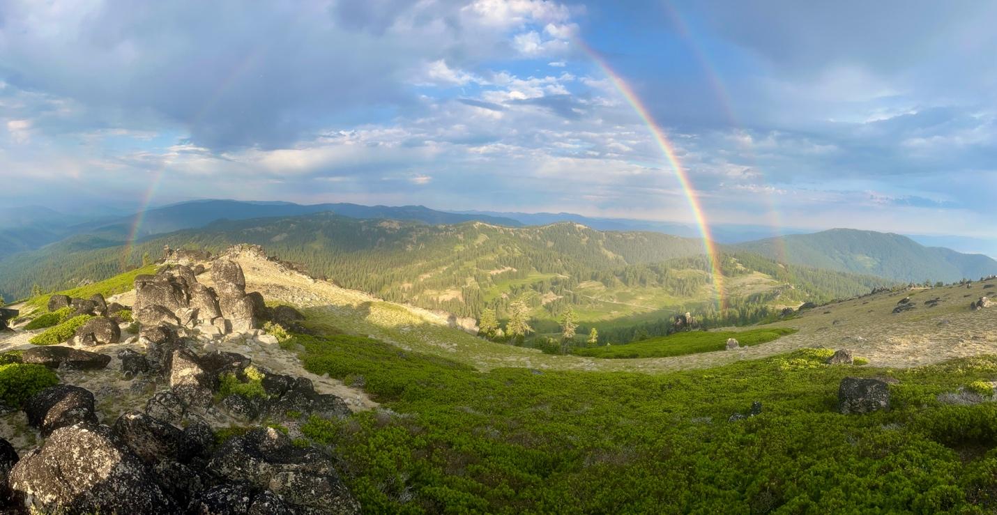
Downscaled climate models and historical records show a reduction in snowpack in the Siskiyou Crest region, including landscapes like the McDonald Peak Inventoried Roadless Area that contain some of the range’s highest elevation habitat (Photo: L. Ruediger)
- Close and decommission a portion of the expansive road network to lower road impacts to streams and wildlife and reduce human-caused wildfires that are much more prevalent along roads compared to roadless areas (Aplet et al. 2026). These human-caused fires include the 15,580-acre 2026 Evans Creek Fire, the 3,000-acre 2020 Almeda Fire that burned over 2500 homes and over 600 businesses in the adjacent Rogue River Valley, and the largest, hottest fire in the SCS, the 157,229-acre 2020 Slater Fire that burned 197 homes in and around Happy Camp, California. Moreover, some 50% of all wildfire ignitions in the KSE are human caused (Schoenaggel et al. 2017).
- Fuel treatments have substantial ecological and financial costs that degrade fire-adapted ecosystems (Lindenmayer et al. 2026) and will have diminished efficacy in a changing climate with extreme fire weather the top driver of fast-moving fires (Balch et al. 2024).
- Higher amounts of high severity wildfires in “managed areas” are consistent with the other ECA findings (3 other areas) and published studies (Bradley et al. 2016, Zald and Dunn 2018).
- For the most effective community protection, start from the home outward, redirect wildfire spending to home hardening and defensible space, plan for more evacuation routes, improve wildfire warning systems, and add smoke shelters as climate change increasingly drives wildfires and overrides fuel treatments (Calkin et al. 2023, Law et al. 2023).
- Additional research is needed at the site level to determine the specific microrefugia properties of the SCS and other potential areas within the KSE by, for instance, measuring temperature, humidity, and wind speeds within old forests compared to thinning and other logged areas and identifying refugia focal taxa.
- Increase support for conservation efforts focused on documenting and protecting biodiversity, promoting habitat connectivity, and permanently protecting habitat within the KSE and SCS.
It is important to note that during the ecoregional workshop held in August 2024, regional experts hypothesized about several taxa that could benefit from protection of presumed refugia. A list of taxa that would benefit from protection of riparian areas and MOG, for instance, include several conifers, vascular plants, butterflies, herpetofauna, birds, mammals, and fish (see Appendix F). Further investigations are needed that link refugia taxa to microclimatic-site measurements to pin down important refugia properties and the taxa that use them. It is the subject of much needed follow up research for the Crest and the KSE writ large.
About The Siskiyou Crest Coalition
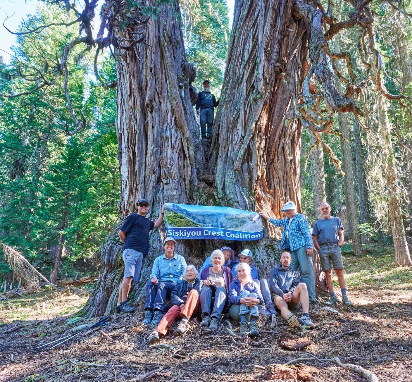
A Siskiyou Crest Coalition hike to the massive Studhorse Cedar in the Condrey Mountain Inventoried Roadless Area (Siskiyou Crest Coalition).
We thank the Siskiyou Crest Coalition for funding this atlas and the published ecoregional conservation assessment. Additional support provided to the lead author was obtained from the Wilburforce Foundation.
The Siskiyou Crest Coalition is a grassroots collaboration of residents, rural property owners, farmers, and representatives of nonprofit organizations, all dedicated to the conservation of the natural environment of the Siskiyou Crest region. Their work principally focuses on permanent protections for federally owned lands to preserve rare and sensitive species and their habitat, protect clean water and important watersheds, and sustain old-growth forests.
Alliance Mission Statement:
The Siskiyou Crest is a regionally significant habitat connectivity corridor linking the Coast Ranges to the Cascade Mountains along the Oregon-California border. The region contains deeply-rooted cultural traditions, world-class biodiversity, important watershed and fisheries, unique geology, old-growth forests, spectacular scenery, vast backcountry habitats, and significant recreational resources. The Siskiyou Crest Coalition (SCC) works to protect and promote these values for future generations through advocacy, education, stewardship, and permanent habitat protections.
About The Contributors
Note – Dominick DellaSala is responsible for most of the content in this atlas. Contributors provided information on specific taxa sections for the Siskiyou Crest mainly.
Dominick A. DellaSala, Conservation Biology Institute, lead author, is a globally renowned conservation scientist with over 350 peer-reviewed science publications and 9 books. He is editor of 6 science journals and has received numerous conservation awards, including: the 2026 Planet Earth Award from the Alliance of World Scientists, conservationist-of-the year awards from World Wildlife Fund (twice) and the Wilburforce Foundation, and Choice Publishers award for scholastic achievement for the book, Temperate and Boreal Rainforests of the World: Ecology and Conservation.
Lincoln Best is the taxonomist for the Oregon Bee Atlas, a statewide initiative to document the diversity and floral relations of nearly 900 species of bees in Oregon, a collaboration with hundreds of Master Melittologist Program volunteers who collect data from every corner of the state.
Gwen W. Bury is a spatial analyst and physiologist who has worked on a variety of species, especially sensitive stream amphibians of the Pacific Northwest. She attended Southern Oregon University for her bachelor’s, Western Washington University for her master’s, and Oregon State University for her PhD. She stayed there for her first post doc (funded by the combined intelligence community) and then worked for the Forest Service for her second, both through ORISE.
R. Bruce Bury is a retired biologist. He received an A.B. from Humboldt State Univ., MSc at Cal State Univ Sacramento, and PhD from UC Berkeley. In 1972, he was the first full–time herpetologist hired by U.S. Fish and Wildlife Service and served five years at the National Museum of Natural History, D.C. Then to Colorado and, in 1993, transferred to Oregon as part of the U.S. Geological Survey. He is author of 180 publications, including six monographs and books.
Michael Kauffmann is an ecologist, author, and educator. He serves as Executive Director of the Bigfoot Trail Alliance and has written or edited several award-winning books on the forests and natural history of western North America. His work connects people to nature through conservation, education, and storytelling.
Dianne Keller is a retired geospatial database manager and butterfly enthusiast. She organizes and participates in two NABA counts in Southern Oregon: Cascade-Siskiyou National Monument count started in 2012 and Siskiyou Crest count started in 2018. Dianne has also been conducting Mardon Skipper surveys for Medford District BLM since 2016 and has produced a population trend report showing that 90% of the Mardon Skipper sites identified in 2009 by US Fish & Wildlife are in decline or unoccupied.
Julie Ann Kierstead retired as Forest Botanist for the Shasta-Trinity National Forest after thirty years, from 1989-2019, conducting rare plant surveys and managing the botany program. From 1983-1988, she served as the first Curator for The Berry Botanic Garden Seed Bank for Rare and Endangered Plants of the Pacific Northwest, in Portland, Oregon; and served as the BBG Conservation Director, where she helped secure passage of the Oregon state endangered species act. She has contributed thousands of photos, observations, and voucher specimens to CalPhotos, Calflora, iNaturalist, and public herbaria. Her focus is on the Klamath Range flora of NW California, where she has published several new plant species. She recently coauthored the book, Wildflowers of California’s Klamath Mountains. She is a California certified consulting botanist and currently serves on the Calflora board of directors.
Frank D. Lospalluto is a field biology technician who has worked throughout southern Oregon and northern California over the last 35 years and is a Klamath Bird Observatory associate. He compiled the e-bird species list for the bird section.
Dana Ross is a recognized expert in Pacific Northwest butterflies and moths (Lepidoptera). His lifelong interest in these insects led to a M.S. degree in Entomology from Oregon State University. Dana currently holds a Courtesy Faculty position within Oregon State University’s Department of Integrative Biology where he serves as a curator of Lepidoptera at the Oregon State Arthropod Collection. He specializes in documenting moths at important ecological sites, on both public and private lands, which have included many of the region’s national wildlife refuges, BLM and USFS land, non-profit nature preserves, and perhaps most notably Crater Lake National Park and the Oregon Caves National Monument and Preserve. Dana is providing the expert moth identification services needed to aid the volunteers and community science efforts. He is identifying and accessioning all the necessary moth samples collected by SCMP volunteers into the carefully curated SCMP drawers at the Oregon State Arthropod Collection.
Luke Ruediger is a naturalist, author, advocate and Siskiyou Crest aficionado. He has lived his entire life in SW Oregon and NW California and has spent almost 25 years living at the heart of the Siskiyou Crest on a remote off-grid homestead below the Red Buttes Wilderness. He is the Conservation Director for Klamath Forest Alliance, Executive Director for Applegate Siskiyou Alliance, and a volunteer for the Siskiyou Crest Coalition. His interests include botany, fire ecology, landscape ecology, forest ecology, Siskiyou Mountain biodiversity, and backcountry exploration. In 2013, he published “The Siskiyou Crest: Hikes, History & Ecology,” a hiking and natural history guide to the region.
Pepper Trail is an ornithologist who has worked for years to study and conserve the wildlife and wildlands of the Klamath-Siskiyou bioregion. He received his Ph.D. from Cornell University in 1984 and was awarded post-doctoral fellowships by the National Science Foundation, the Smithsonian, and the California Academy of Sciences. He is a Fellow of the American Ornithological Society, and the author of over 30 peer-reviewed papers in ornithology. From 1998 until his retirement in 2021, he was the Senior Ornithologist at the National Fish and Wildlife Forensic Laboratory of the US Fish and Wildlife Service.
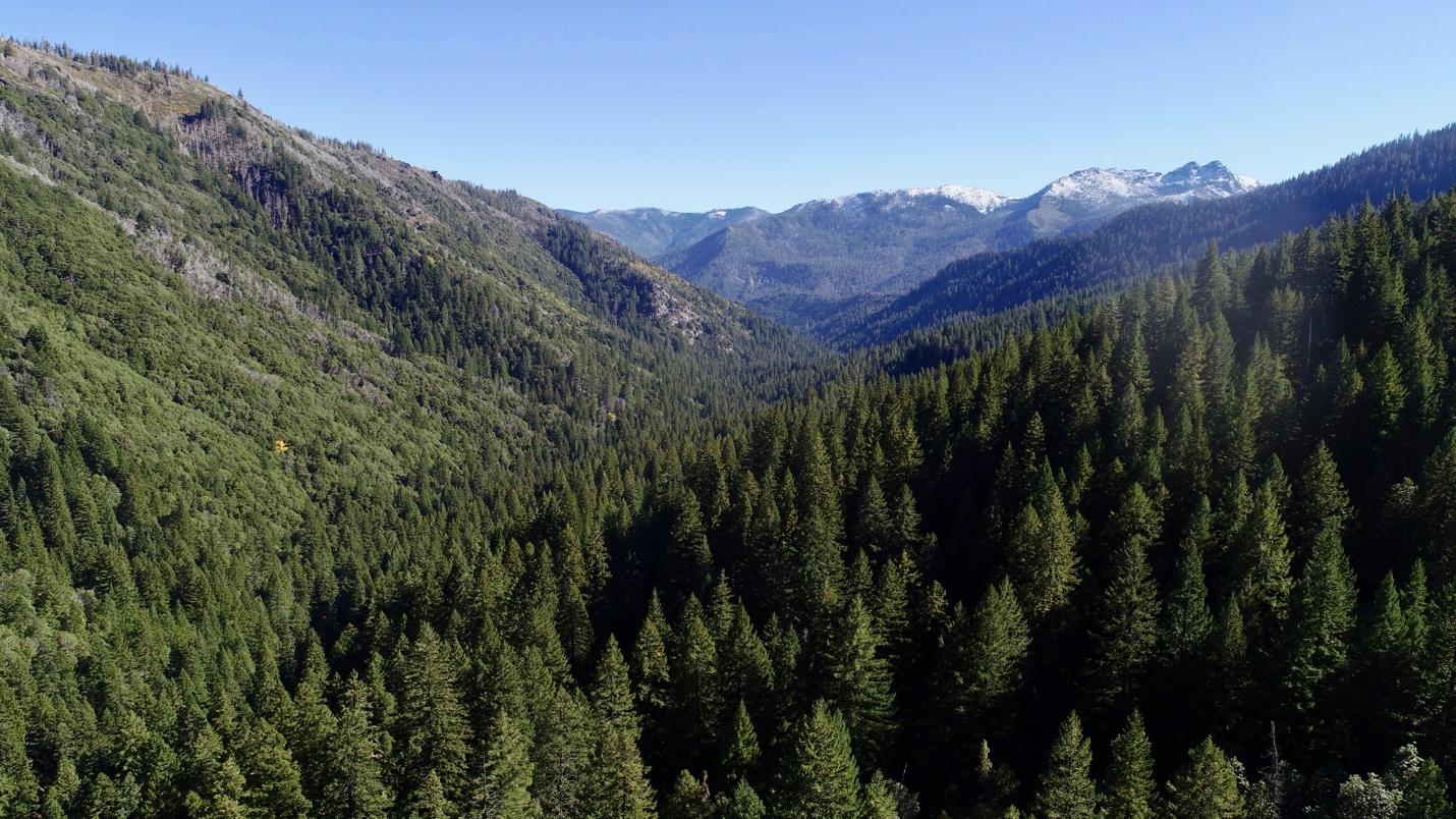
Middle Fork Applegate watershed, Siskiyou Crest (Photo: Applegate Siskiyou Alliance)