
The Micronesia Challenge is a commitment by the Republic of Palau, Guam, the Commonwealth of the Northern Mariana Islands, the Federated State of Micronesia, and the Republic of the Marshall Islands to preserve the marine and terrestrial resources that are crucial to the survival of the Pacific traditions, cultures and livelihoods. The overall goal of the Micronesia Challenge is to effectively conserve at least 30% of the near-shore marine resources and 20% of the terrestrial resources across Micronesia by 2020. The USFS Forest Inventory and Analysis (FIA) team, regional partners and CBI developed the Micronesia Challenge Regional Terrestrial Monitoring Initiative tool (mcterrestrialmeasures.org) to allow users to visualize the spatial data from the Micronesia Challenge monitoring effort by regional framework indicator(s) that measure the status of managed conservation areas set aside under the program. Forest data were collected between 2003 and 2018 and are now being used to determine the status and trends in forest area, forest health, understory vegetation, biomass, and carbon storage.
Southern California NCCPs support edaphic endemic plants that face low genetic diversity due to reduced population sizes, geographic isolation, and loss of pollinators. To enhance the resilience of these species across their ranges, we must manage threats to increase population sizes, identify potentially suitable habitat to connect existing populations, find or restore new populations, and provide opportunities for shifting distributions due to climate change. The Management Strategic Plan for San Diego County requires prioritization and management for edaphic endemic plants, including the five species addressed in this proposal: Acanthomintha ilicifolia, Brodiaea filifolia, Deinandra conjugens, Nolina interrata, and Tetracoccus dioicus. Regional goals include maintaining or expanding existing occurrences or establishing new occurrences to increase resilience to environmental stochasticity, maintaining genetic diversity, and ensuring persistence over the long-term in native plant communities.
This study presents an approach for identifying and describing geographic areas that support edaphic endemic species and their habitat in a design that enhances resilience and provides opportunities for shifting distributions. We developed conceptual models to inform field studies and management, refined soils and vegetation attributes, and assessed regional population structure and threats. We used results to suggest prioritized locations for surveys, management, potential translocation, and additional conservation or acquisition. Project partners (U.S. Geological Survey and San Diego Management and Monitoring Program) modeled suitable habitat for the target species under current and future climate scenarios; we reference models as appropriate.
All target species occur on nutrient poor soils, and each species is associated with a unique suite of physical and chemical soil properties. We provide a range of variables for each species that can inform site selection for management and restoration. Testing soil before enhancing or augmenting small occurrences will allow us to locate suitable sites and eliminate or remediate unsuitable sites with remnant populations before investing management funds.
We used distribution data, habitat suitability models, genetic principles and information to develop regional population structures for each target species. We then identified populations or population groups important for long-term resilience and locations where conservation and management actions would be most beneficial.
Models predict declining habitat in the future for all target species under various climate scenarios, although the amount of predicted habitat remaining varies among species. We recommend conserving future predicted suitable habitat within or beyond San Diego County, and experimentally translocating target species into this habitat as climatic conditions change if monitoring indicates further species declines.
This work contributes to San Diego NCCP subarea plans in progress and other NCCPs. The project area includes the North County MSCP, South County MSCP, and MHCP.
CBI biologists Patricia Gordon-Reedy, Spring Strahm, and Jessie Vinje worked with the San Diego Management and Monitoring Program, U.S. Fish and Wildlife Service, California Department of Fish and Wildlife, The Nature Conservancy, Space and Naval Warfare Systems Command (SPAWAR), and San Diego County land managers on this project. The California Department of Fish and Wildlife funded this work under a Local Assistance Grant.
The U.S. Forest Service, Oregon State University, and Conservation Biology Institute have collaboratively developed the Seedlot Selection Tool to help forest managers match tree seed collections (called seedlots) with planting sites to help ensure the resilience of forests in a changing climate.
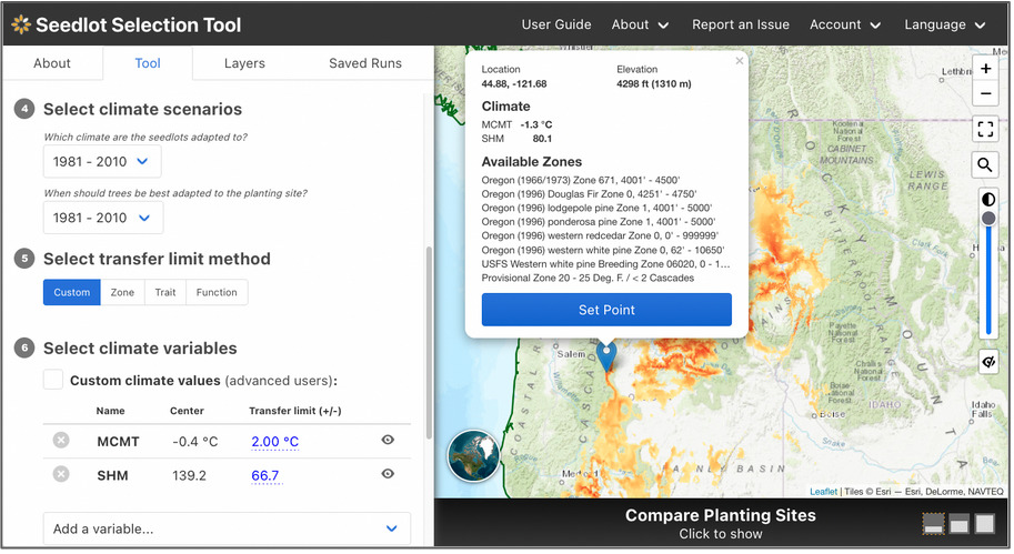
The Seedlot Selection Tool (or SST) is a free web-based decision-support tool that can be used to map planting locations based on either current climate data or a range of possible future climates across the conterminous U.S. and Mexico. Users can select a tree species, a climate scenario and relevant climate variables for the species, and other parameters to identify sources of seedlots appropriate for planting on a particular site or planting sites that are appropriate for planting seedlings from a particular seedlot. A valuable planning and educational tool, the SST helps explore possible future conditions, assess risk, and plan potential responses as part of a decision about which seedlot seedlings will be best adapted to a particular planting site in the future.
Seedlot Selection Tool Guidebook for US Forest Service Region 6 Silviculturists
Seedlot Selection Tool Video Tutorial for US Forest Service Region 6 Silviculturists
The SST was spearheaded by Glenn Howe at Oregon State University and Brad St. Clair at the USFS Pacific Northwest Research Station and developed by Nikolas Stevenson-Molnar, Brendan Ward, and Dominique Bachelet at CBI. Recently the USDA Climate Hub and USFS Region 6 staff worked with CBI to develop a step-by-step Guidebook and Video Tutorial for the Seedlot Selection Tool for Region 6 Silviculturists. These materials are useful to anyone who wants to learn about the use of this resource.
You may access the SST and detailed instructions at https://seedlotselectiontool.org/sst/.
Please see the USDA Climate Hub Seedlot Selection Tool Web Page for more information about the Guidebook and Tutorial Video.
Support for the SST came from the USFS, OSU, CBI, and the USDA Northwest Climate Hub.
CBI is expanding on previous work with the Peninsular Florida Landscape Conservation Cooperative (PFLCC) to further develop the PFLCC Simple Viewer to provide greater functionality and flexibility. In March 2017, CBI worked with PFLCC to incorporate PFLCC’s Blueprint version 1.0 into the viewer, and also created new reporting functionality to export on-screen results to PDF. In July 2017, CBI introduced the ability to aggregate multiple watersheds for display of summary information. This is particularly useful for users whose areas of interest and jurisdictions span multiple watersheds.
CBI is currently working on creating a Conservation Actions Tracker that will be added to the PFLCC Conservation Planning Atlas developed by CBI using Data Basin. This Conservation Actions Tracker will to allow users throughout Florida to enter information about conservation actions on the landscape – such as restoration activities – using an intuitive map-oriented interface. Users will also be able to explore any conservation actions in the system, and discover opportunities for collaboration and shared impact.
CBI is in the process of designing a new interactive application to showcase the PFLCC climate change adaptation guide so that users will be able to use interactive maps and data visualization to gain a greater understanding of climate change adaptations within Florida landscapes.
CBI and AECOM Technical Services, Inc. are coordinating and implementing regional rare plant monitoring in San Diego County to determine status, threats, and management actions for 27 highly restricted rare plants. This work is in partnership with the San Diego Association of Governments (SANDAG), San Diego Management and Monitoring Program (SDMMP), U.S. Geological Survey (USGS), and San Diego County land managers. Many of these rare plant species are declining due to invasive plants, small population size, or other threats. For some species, status or presence of one or more populations are unknown. Thus, key objectives of the program are to (1) determine current status, (2) document threats and vulnerabilities, and (3) identify appropriate management to ensure long-term species persistence.
CBI worked with project partners to test and refine the Management Strategic Plan (MSP) Inspect and Manage (IMG) rare plant monitoring protocol and data collection methods in 2014 and 2015, and we continue to refine the program, as necessary. Currently, CBI trains land managers and other participants in the IMG protocol method at workshops and in the field, conducts rare plant surveys across the county, compiles and manages survey data, and coordinates with project partners on all project components.
Regional monitoring data identify trends and priorities for management. Monitoring results guide land managers in routine management or provide information so they can apply for regional funding for management actions that exceed routine capacity and budgets. Next steps for the project include assessing rare plant population status and threats through 2021.
Scientists at The Wilderness Society (TWS), under the direction of Dr. Greg Aplet, are developing a collaborative conservation strategy that is especially pertinent during the new era of accelerated Climate Change. In short, the strategy is for society to designate a portfolio of three management strategies, zoned in large, contiguous areas across the landscape:
• Restoration zones where we try to repair the landscape and restore natural ecological patterns and processes that then can adapt to change
• Innovation zones in which the landscape is devoted to innovative management that anticipates climate change and guides ecological change to prepare for it; and,
• Observation zones in which the landscape is left to change on its own time to serve as a scientific “control” and to hedge against the unintended consequences of active management elsewhere.
The large contiguous areas are essential to minimize the deleterious edge effects that happen when the negative aspects of one zone bleed into the neighboring zone. The problem and the strategy are detailed more in a short article in the Pinchot Letter.
Given this strategy, a whole host of questions arise about where and how these zones should be mapped on the landscape. TWS has contracted Conservation Biology Institute (CBI) to help address these spatial challenges. The answers are context specific, so we are building a spatial decision support system (SDSS) to aid with these questions for any given landscape. A good SDSS combines information and human values in a systematic manner to provide maps, charts, and reports in a variety of easy-to-use formats, including within a web-browser. The CBI/TWS partnership is building a prototype SDSS now, using the Sierra Nevada mountains in California as a pilot study area. The SDSS is to be transparent, and customizable to the politics and ecology of a given region. Hence, we are building it on top of the Environmental Evaluation Modeling System (EEMS) using ArcGIS models and scripts, and the products are viewable to project advisors via Data Basin and EEMS Explorer (the EEMS graphical user interface in Data Basin).
Some of the methods and specifications for the foundation of the SDSS are as follows:
• A region of study is divided into a large set of spatially explicit reporting units (or planning units) that cover the region in entirety.
• The end user can choose from a variety of nested regions of study (such as the Sierra Nevada Forest Plan Reference Region, the Southern Sierra Nevada, or Sierra National Forest).
• The SDSS is to provide spatially explicit scenarios, each based on a set of parameter values and assumptions.
• For each scenario, each reporting unit in the study region is assigned to one of the three zones. This is to provide decision support, not decision making.
• Reporting units are selected for one zone or another based on both the composition of the unit as well as its spatial context.
Some of the details about the allocation algorithm are as follows:
• Many composition criteria can be considered; for now, there are 13 relating to the suitability and influence of pre-existing land designations, one regarding fire management, and 3 regarding ecological condition. For instance, Wilderness Areas are more suitable for the observation zone than the other two zones.
• A representation algorithm makes sure that reporting units allocated to each zone are distributed among one or several elevation bands, and several sub regions. (More geographic classes, such as habitat type, are pending.)
• A preliminary contiguity algorithm ensures that the allocations for each zone are clumped thereby minimizing fragmentation and deleterious edge effects.
• Addition of a CBI algorithm is pending that will further improve connectivity between core areas of each zone, thereby facilitating species movement within a zone during a changing climate.
The SDSS is currently in the Prototype stage that will undergo an evaluation and another round of development before release to partners. If anyone is interested in providing input, advice, and/or reviews on the work in progress at some point, or simply joining the announcement list, please contact Dr. Greg Aplet or Dr. John Gallo. Please contact Dr. Gallo regarding potential collaborations customizing the SDSS code and methodology for other types of multi-objective allocation projects.
The Southern Sierra Nevada Fisher Conservation Assessment and Strategy is multi-agency effort led by CBI to conserve and recover an imperiled population of Pacific fisher (Pekania pennanti) in the southern Sierra Nevada in California. Beginning in 2007, the project was originally a voluntary collaboration amongst agencies sharing an interest in conserving fishers. However, the southern Sierra Nevada “distinct population” of fishers was listed as Endangered under the U.S. Endangered Species Act in 2020, and the project is therefore being restructured to better align with the regulatory process that the U.S. Fish and Wildlife Service (USFWS) must follow to develop an endangered species recovery plan.
Since 2007, CBI has supported the project with scientific analyses and led the effort that produced a comprehensive state-of-the-science assessment in 2015 (Southern Sierra Nevada Fisher Conservation Assessment) and a draft conservation strategy in 2016 (Southern Sierra Nevada Fisher Conservation Strategy). However, dramatic changes in fisher habitat due to historic drought and extreme wildfire impacts, coupled with the listing of the population as Endangered in 2020, have necessitated a complete re-evaluation of the species’ status and new approaches for conserving and recovering the population. In support, the California Department of Fish and Wildlife (CDFW) provided CBI with a “Section 6” grant in June 2024 to guide this next phase of planning.
Previous Southern Sierra Fisher Conservation Assessments and Strategies
The 2015 Southern Sierra Nevada Fisher Conservation Assessment and 2016 Southern Sierra Nevada Fisher Conservation Strategy were completed with funding provided by the Sierra Nevada Conservancy (SNC), USDA Forest Service (Pacific Southwest Region), Resources Legacy Fund, and US Fish and Wildlife Service (USFWS). The Assessment summarized the best available scientific information on fishers and their habitats in the area at that time, including population size, distribution, and trends; ecology; habitat requirements across multiple spatial scales (from the population or landscape scale to the scale of individual denning or resting structures); and threats to fishers and their habitat. The 2016 Conservation Strategy used this information to provide guidance for reducing threats and increasing the quality and resiliency of fisher habitat. It was compatible with diverse agency missions, objectives, and legal requirements, meeting the needs of multiple agencies with an interest in fisher conservation and land management in the Sierra Nevada.
A New Approach
Now, beginning in 2024, CBI will be working with partners to adapt and update the information in all of the previous products with the latest scientific information and context. This current approach will closely align with new USFWS guidance for their statutorily mandated Endangered Species Recovery Planning process. In keeping with this guidance, the project will produce a new Species Status Assessment (SSA), a Recovery Plan, and a Recovery Implementation Strategy (RIS) using the best available scientific information. More information on the USFWS recovery planning process can be found at Recovery Planning Implementation.
For more information about this effort, please contact Wayne Spencer, wdspencer@consbio.org, or Deanne DiPietro deanne.dipietro@consbio.org.
Conserved lands in southern San Diego County form the cornerstone of the San Diego Natural Community Conservation Planning (NCCP) network. This region supports the largest expanse of remaining coastal habitats in southern California—coastal sage scrub, maritime succulent scrub, chaparral, riparian woodlands, vernal pools, and grasslands. Intact landscapes are critical to genetic interchange within plant and animal populations and allow dispersal and recolonization of new areas. Large landscapes that span elevational gradients, such as this core area in south San Diego County, also enable populations to shift in response to environmental and land use changes.
State Route 94 (SR-94) cuts through the heart of this core area, potentially impeding wildlife movement across otherwise intact landscapes. New residential development and a casino under construction in Jamul will increase traffic and potentially impact the wildlife value and connectivity of adjacent conserved lands. Proposed road improvements associated with these new land uses provide an opportunity to mitigate the potential barrier effects of SR-94. Scientific literature suggests that strategically-placed wildlife fencing along roads, combined with effective wildlife crossing areas (e.g., undercrossings, overcrossings, bridges) are the most effective means of influencing animal behavior and directing animal movement, thereby reducing roadkill, enhancing connectivity, and improving traffic safety.
The purpose of this document is to provide available background information and connectivity objectives for multiple taxa that use this area and to identify potential infrastructure examples that could improve connectivity across the south county preserves. This document describes land uses, vegetation communities, and existing infrastructure along 12 miles of SR-94 and identifies potential locations, by road segment, where enhancements to existing undercrossings and additional fencing could facilitate wildlife movement across conserved lands. Because there are little wildlife movement data for this area, we outline wildlife movement studies and systematic collection of roadkill data that should begin now to inform and refine the actual design and placement of wildlife fencing and crossing structures. Once implemented, post-construction monitoring should be conducted to ensure that the new infrastructure is functional and cost-effective.
CBI and AECOM worked with the San Diego Management and Monitoring Program (SDMMP) and U.S. Geological Survey (USGS) – with oversight from the wildlife agencies – to develop preserve management plans that incorporate elements of the Management Strategic Plan for Conserved Lands in western San Diego County, related Strategic Plans for invasive species and wildlife connectivity, and any relevant regional habitat conservation subarea plans. These management plans serve as pilots for the standardized development of resource management plans by other land managers throughout the region. We developed plans for two preserve complexes: (1) the Southwest Otay Mesa preserve complex, which includes lands owned and managed by the City of San Diego, County of San Diego, and California Department of Transportation (Caltrans) and (2) the Greater Crestridge Ecological Reserve Complex, which includes lands owned and managed by the Endangered Habitats Conservancy (EHC). The latter plan was finalized (including a detailed, 5-year budget) in 2017, updated with additional preserves in 2018, and is being implemented by EHC land managers.
Plan development differs from traditional approaches in that we conducted rapid assessments to identify threats that needed immediate management attention rather than comprehensive biological surveys. We also identified potentially-occurring biological resources, future survey needs, preserve-specific management priorities, SMART goals, objectives, and action items, and opportunities for coordinated management across preserve boundaries.
Funding for this project was through the San Diego Association of Governments (SANDAG), with additional funding from the Endangered Habitats Conservancy to update the Greater Crestridge Ecological Reserve Complex Framework Resource Management Plan.
Working closely with the Natural Resources Defense Council (NRDC), CBI conducted an assessment of the risk to the bottomland hardwood/wetland forests of the US Southeast to the growing threat from the wood pellet industry largely to fuel power plants throughout the European Union (EU). The final report released by NRDC was entitled, “In the U.S. Southeast, Natural Forests are Being Felled to Send Fuels Overseas“.
This report details the threats facing Southeastern U.S. Forests, which is widely recognized as one of the world’s biodiversity hotspots, from the wood pellet industry, which has seen a 150 percent increase in wood pellet exports between 2012-2015. The report explains that 24 million acres of unprotected Southeastern forest lands are at risk and predicts that pellet manufacturing could increase to be twelve times larger than it currently is by 2020. For a one-hour webinar dedicated to this topic, see Bioenergy Threatens Wetland Forests of the US Southeast.