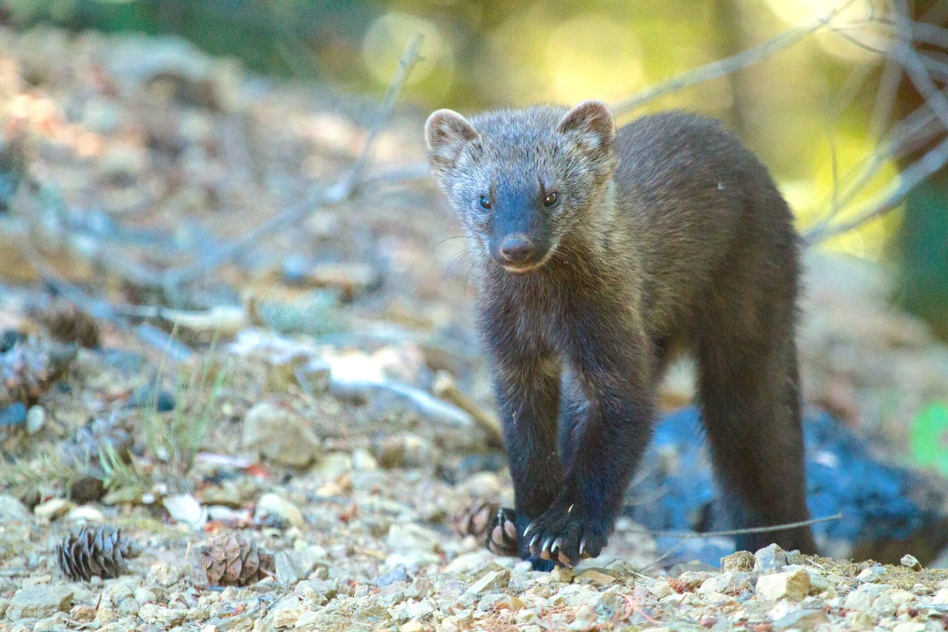
The Southern Sierra Nevada Fisher Conservation Assessment and Strategy is multi-agency effort led by CBI to conserve and recover an imperiled population of Pacific fisher (Pekania pennanti) in the southern Sierra Nevada in California. Beginning in 2007, the project was originally a voluntary collaboration amongst agencies sharing an interest in conserving fishers. However, the southern Sierra Nevada “distinct population” of fishers was listed as Endangered under the U.S. Endangered Species Act in 2020, and the project is therefore being restructured to better align with the regulatory process that the U.S. Fish and Wildlife Service (USFWS) must follow to develop an endangered species recovery plan.
Since 2007, CBI has supported the project with scientific analyses and led the effort that produced a comprehensive state-of-the-science assessment in 2015 (Southern Sierra Nevada Fisher Conservation Assessment) and a draft conservation strategy in 2016 (Southern Sierra Nevada Fisher Conservation Strategy). However, dramatic changes in fisher habitat due to historic drought and extreme wildfire impacts, coupled with the listing of the population as Endangered in 2020, have necessitated a complete re-evaluation of the species’ status and new approaches for conserving and recovering the population. In support, the California Department of Fish and Wildlife (CDFW) provided CBI with a “Section 6” grant in June 2024 to guide this next phase of planning.
Previous Southern Sierra Fisher Conservation Assessments and Strategies
The 2015 Southern Sierra Nevada Fisher Conservation Assessment and 2016 Southern Sierra Nevada Fisher Conservation Strategy were completed with funding provided by the Sierra Nevada Conservancy (SNC), USDA Forest Service (Pacific Southwest Region), Resources Legacy Fund, and US Fish and Wildlife Service (USFWS). The Assessment summarized the best available scientific information on fishers and their habitats in the area at that time, including population size, distribution, and trends; ecology; habitat requirements across multiple spatial scales (from the population or landscape scale to the scale of individual denning or resting structures); and threats to fishers and their habitat. The 2016 Conservation Strategy used this information to provide guidance for reducing threats and increasing the quality and resiliency of fisher habitat. It was compatible with diverse agency missions, objectives, and legal requirements, meeting the needs of multiple agencies with an interest in fisher conservation and land management in the Sierra Nevada.
A New Approach
Now, beginning in 2024, CBI will be working with partners to adapt and update the information in all of the previous products with the latest scientific information and context. This current approach will closely align with new USFWS guidance for their statutorily mandated Endangered Species Recovery Planning process. In keeping with this guidance, the project will produce a new Species Status Assessment (SSA), a Recovery Plan, and a Recovery Implementation Strategy (RIS) using the best available scientific information. More information on the USFWS recovery planning process can be found at Recovery Planning Implementation.
For more information about this effort, please contact Wayne Spencer, wdspencer@consbio.org, or Deanne DiPietro deanne.dipietro@consbio.org.
Conserved lands in southern San Diego County form the cornerstone of the San Diego Natural Community Conservation Planning (NCCP) network. This region supports the largest expanse of remaining coastal habitats in southern California—coastal sage scrub, maritime succulent scrub, chaparral, riparian woodlands, vernal pools, and grasslands. Intact landscapes are critical to genetic interchange within plant and animal populations and allow dispersal and recolonization of new areas. Large landscapes that span elevational gradients, such as this core area in south San Diego County, also enable populations to shift in response to environmental and land use changes.
State Route 94 (SR-94) cuts through the heart of this core area, potentially impeding wildlife movement across otherwise intact landscapes. New residential development and a casino under construction in Jamul will increase traffic and potentially impact the wildlife value and connectivity of adjacent conserved lands. Proposed road improvements associated with these new land uses provide an opportunity to mitigate the potential barrier effects of SR-94. Scientific literature suggests that strategically-placed wildlife fencing along roads, combined with effective wildlife crossing areas (e.g., undercrossings, overcrossings, bridges) are the most effective means of influencing animal behavior and directing animal movement, thereby reducing roadkill, enhancing connectivity, and improving traffic safety.
The purpose of this document is to provide available background information and connectivity objectives for multiple taxa that use this area and to identify potential infrastructure examples that could improve connectivity across the south county preserves. This document describes land uses, vegetation communities, and existing infrastructure along 12 miles of SR-94 and identifies potential locations, by road segment, where enhancements to existing undercrossings and additional fencing could facilitate wildlife movement across conserved lands. Because there are little wildlife movement data for this area, we outline wildlife movement studies and systematic collection of roadkill data that should begin now to inform and refine the actual design and placement of wildlife fencing and crossing structures. Once implemented, post-construction monitoring should be conducted to ensure that the new infrastructure is functional and cost-effective.
CBI and AECOM worked with the San Diego Management and Monitoring Program (SDMMP) and U.S. Geological Survey (USGS) – with oversight from the wildlife agencies – to develop preserve management plans that incorporate elements of the Management Strategic Plan for Conserved Lands in western San Diego County, related Strategic Plans for invasive species and wildlife connectivity, and any relevant regional habitat conservation subarea plans. These management plans serve as pilots for the standardized development of resource management plans by other land managers throughout the region. We developed plans for two preserve complexes: (1) the Southwest Otay Mesa preserve complex, which includes lands owned and managed by the City of San Diego, County of San Diego, and California Department of Transportation (Caltrans) and (2) the Greater Crestridge Ecological Reserve Complex, which includes lands owned and managed by the Endangered Habitats Conservancy (EHC). The latter plan was finalized (including a detailed, 5-year budget) in 2017, updated with additional preserves in 2018, and is being implemented by EHC land managers.
Plan development differs from traditional approaches in that we conducted rapid assessments to identify threats that needed immediate management attention rather than comprehensive biological surveys. We also identified potentially-occurring biological resources, future survey needs, preserve-specific management priorities, SMART goals, objectives, and action items, and opportunities for coordinated management across preserve boundaries.
Funding for this project was through the San Diego Association of Governments (SANDAG), with additional funding from the Endangered Habitats Conservancy to update the Greater Crestridge Ecological Reserve Complex Framework Resource Management Plan.
Working closely with the Natural Resources Defense Council (NRDC), CBI conducted an assessment of the risk to the bottomland hardwood/wetland forests of the US Southeast to the growing threat from the wood pellet industry largely to fuel power plants throughout the European Union (EU). The final report released by NRDC was entitled, “In the U.S. Southeast, Natural Forests are Being Felled to Send Fuels Overseas“.
This report details the threats facing Southeastern U.S. Forests, which is widely recognized as one of the world’s biodiversity hotspots, from the wood pellet industry, which has seen a 150 percent increase in wood pellet exports between 2012-2015. The report explains that 24 million acres of unprotected Southeastern forest lands are at risk and predicts that pellet manufacturing could increase to be twelve times larger than it currently is by 2020. For a one-hour webinar dedicated to this topic, see Bioenergy Threatens Wetland Forests of the US Southeast.
The availability and accessibility of accurate information increases the likelihood of efficient allocation of conservation resources to those areas that can maximize protection of biodiversity. This is especially true as conservationists respond to the complex and uncertain ecological changes triggered by climate change. To date, systematic conservation plans have been based on current patterns of biodiversity. However, climate-driven shifts in biomes, species, and ecosystem functions have the potential to make plans based on current patterns of biodiversity less effective. Conservation strategies that lack access to information on the location of areas that maximize resiliency, the methods for climate adaptation conservation planning as well as the pros and cons of the available approaches may misallocate resources by allowing key areas to remain unprotected.
CBI has built AdaptWest – Climate Adaptation Conservation Planning Database for Western North America powered by Data Basin in partnership with project Scientists Carlos Carroll, Josh Lawler and Scott Nielsen. AdaptWest will build on previous work such as the Yale Framework and Reed Noss’s three track approach to conservation planning (Noss and Cooperrider 1994) to provide a coherent planning framework for climate adaptation conservation. AdaptWest will include a comprehensive comparison and synthesis of the many planning approaches that have previously been developed, along with detailed explanation of the application of those methods to the majority of western North America. It will describe whether those conservation efforts are complementary or duplicative, develop a spatial database from the results of these analyses and provide users with integrative analyses and tools that can inform climate adaptation conservation planning and prioritization across much of western North America.
This project differs from previous studies in that it seeks to 1) compare a full spectrum of alternative methods over many contrasting regions, and 2) refine understanding of the conceptual relationship between the various methods and their practical relationship in the planning process. The results of this project, including physical habitat data, climate data, and species model based metrics and prioritizations as well as integrated priority mapping, will be available on Data Basin.
CBI is providing scientific and technical support to Greenpeace Canada and AV Terrace Bay as they work together to maintain the ecological integrity of the Kenogami-Ogoki Forests in Ontario, Canada while providing a sustainable wood supply to the AV Terrace Bay mill and protecting cultural values of First Nations peoples.
There are two major, interrelated components of the project. First, CBI is examining a series of important aspects of woodland caribou conservation in the region, which has been a major focus throughout boreal Canada for a number of years as ongoing development is continually eroding woodland caribou habitat resulting in serious declines in some populations. Using data provided by the Ontario government, CBI is attempting to identify key caribou activity areas, regional movement patterns, and crucial habitat.
CBI is also creating a series of risk-based protected areas scenarios by defining areas of high landscape value and high biological value. High biological value is determined by considering representation of native ecosystems, overall forest values, concentrations of rare species, wetlands, and vital woodland caribou habitat.
Upon development of the scenarios, CBI will facilitate a discussion to review the trade-offs of the different scenarios between AV Terrace Bay and Greenpeace Canada, using Data Basin to support the discussion given the spatially explicit nature of the effort. In the end, the hope is to forge a land management agreement between the two parties that will allow for sustained economic development of the forest resources while protecting the ecological integrity of the region (including woodland caribou viability) and cultural values of the local First Nations peoples.
CBI is working with Utah’s Division of Wildlife Resources (DWR) and The Bureau of Land Management to develop decision support models to inform current conservation initiatives in Utah and throughout the Colorado Plateau ecoregion. Based on previous REA (Rapid Ecoregional Assessment) work, CBI is updating the existing terrestrial landscape and aquatic intactness models for the Colorado Plateau ecoregion as well as updating habitat profiles for a number of identified conservation elements of interest (largely native species and communities). CBI is extending the models to cover the entire state of Utah as well as fine-tuning the models to be more effective at answering different management questions over smaller geographic areas.
CBI is also updating a previously created climate stress logic model with the most recent climate data from the 5th Intergovernmental Panel on Climate Change (IPCC) report as well as carryout some new analyses. For example, mapping potential climate refugia – areas where plants and animals may find shelter from changes in climatic conditions. CBI is also examining past and future climate variability to model climate velocity, which is the speed along the Earth’s surface needed to maintain constant climate conditions with the rationale being that species survival may depend as much on keeping pace with moving climate as the climate’s ultimate persistence. Results of the climate modeling will illustrate at the landscape level the degree to which locations in the landscape will be impacted by climate stress over the next century and help estimate the likelihood that certain species will survive shifting suitable habitat conditions.
Click here to see the console.
The Conservation Biology Institute, in collaboration with Ted Weller (USFS – Pacific Southwest Research Station) is expanding the functionality of Data Basin to create a clearinghouse for migratory bat detection data. This new functionality will allow users to: (1) import location-aware spreadsheet data into Data Basin; (2) dynamically visualize these locations and their attributes (such as number of bats of a particular species) within the interactive map; and, (3) explore charts of time series records across one or more locations. Additional tools under development will allow aggregation into a single master dataset, support form-based imports to more easily capture site and detector information from researchers during upload, and support export of records into spatial and non-spatial outputs.
More information about the exciting implications of this project can be found within an article on The Wildlife Society website.
Working as a subcontractor to Dynamac Corporation, the Conservation Biology Institute provided the scientific leadership and technical support for two BLM Rapid Ecoregional Assessment (REAs). The Sonoran Desert ecoregion was completed in the spring of 2012. A series of conservation elements were chosen for the eocregion and over 40 management questions addressed. Most questions pertained to a listed set of change agents, including urban and agriculture development, energy (including renewables), fire, invasive species, recreation, and climate change. For each conservation element, conceptual models were created and, for each specific management question, an accompanying GIS-based process model was created that outlined the data and steps necessary to generate an answer to the question. Part of the project required an exhaustive acquisition and review of available spatial data – hundreds the ecoregion. Extensive and sophisticated modeling had to be applied to multiple topics including target species habitat, natural ecological systems, climate change, invasive species, wildfire, and landscape integrity. Also, some custom analytical software had to be generated throughout the course of the project.
Project review was conducted using Data Basin and final results reside in a private group space on this web-based data management and mapping system. To inquire about access to the data and map-based results, please contact Karen Prentice at BLM Headquarters (kprentice@blm.gov).
To download the report and find out more information, Click Here.
Working as a subcontractor to Dynamac Corporation, the Conservation Biology Institute provided the scientific leadership and technical support for two BLM Rapid Ecoregional Assessment (REAs). The Colorado Plateau ecoregion was completed in the spring of 2012. A series of conservation elements were chosen for the eocregion and over 40 management questions addressed. Most questions pertained to a listed set of change agents, including urban and agriculture development, energy (including renewables), fire, invasive species, recreation, and climate change. For each conservation element, conceptual models were created and, for each specific management question, an accompanying GIS-based process model was created that outlined the data and steps necessary to generate an answer to the question. Part of the project required an exhaustive acquisition and review of available spatial data – hundreds the ecoregion. Extensive and sophisticated modeling had to be applied to multiple topics including target species habitat, natural ecological systems, climate change, invasive species, wildfire, and landscape integrity. Also, some custom analytical software had to be generated throughout the course of the project.
Project review was conducted using Data Basin and final results reside in a private group space on this web-based data management and mapping system. To inquire about access to the data and map-based results, please contact Karen Prentice at BLM Headquarters (kprentice@blm.gov).
To download the full report and find our more information on the Colorado Plateau REA, click here.