
CBI investigated the effects of climate and vegetation on the distribution of martens (Martes caurina) and fishers (Martes pennanti) in the Sierra Nevada in California under current and projected 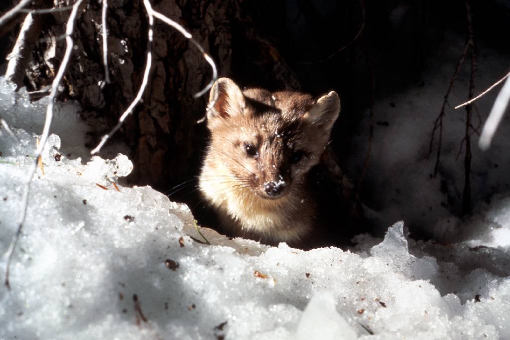 future conditions to inform conservation efforts for these species and to investigate how different modeling methods and resolutions may affect predictions about species’ responses to climate change. Martens and fishers are closely related forest carnivores of conservation concern in California, where both reach their southernmost distributions. The species have contiguous elevation ranges, with the smaller marten occupying high subalpine forests that experience deep and persistent snow, and the larger fisher occupying mid-elevation forests that experience less snow and warmer temperatures.
The goals of this project were to:
- add robust, downscaled, climate-change effects assessments to CBI’S Sierra Nevada Carnivores project, which is a comprehensive, science-based effort to map areas important to sustaining rare carnivore populations and improving forest management.
- compare alternative analytical approaches and resolutions for assessing climate impacts on vegetation and sensitive species.
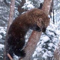 Because martens and fishers require similar forest structural conditions (dense forests with large trees and abundant dead wood) but different climate regimes (cooler, moister, and snowier conditions for martens; warmer, drier and less snowy conditions for fishers) they offer a unique opportunity to investigate how our changing climate may affect the species directly as well as via changes in vegetation. Also, because they compete with one another for food, and fishers will kill martens when they meet, this system offers an opportunity to investigate how species interactions may also affect future populations.
Specific study tasks:
- Examine how the current distributions of martens and fishers are influenced by vegetation characteristics (e.g., forest composition and structure), climate (e.g., temperature, precipitation, snow depth and duration), physical variables (e.g., elevation, % slope) and presence or absence of the other species.
- Project the potential future distribution of both species under climate change based on results of Task 1 and using alternative emissions scenarios and general circulation models at different resolutions.
- Use the results to support conservation and forest management plans to ensure long-term sustainability of marten and fisher populations in the face of climate change and increasingly severe fire regimes.
Click here for Methods, Outcomes, Interpretation and Related Data
National interest in roadless area conservation dates back to the 1970s when the Forest Service was directed by Congress to inventory roadless areas in response to the public’s growing desire to protect wild landscapes primarily through wilderness designations. In 2001, President Clinton enacted the Roadless Conservation Rule to protect 58.5 million acres of inventoried roadless areas on Forest Service lands, including nearly 2 million acres in Oregon. However, on May 13, 2005 the Bush administration issued a revised rule that established a process for governors to propose locally supported regulations for conserving roadless area within their states. While some states, including Oregon, have legally challenged this rule change, State governments will continue to play a vital role in providing recommendations to the Forest Service concerning the protection of federal roadless areas. This report provides new information on the importance of roadless areas in Oregon that places these areas among the most ecologically valued in the nation, thereby providing a scientific foundation for protecting all of Oregon’s roadless lands regardless of the method to achieve this outcome.
CBI staff outlined the crucial role that Southern Orange County, California, could play in efforts to conserve biodiversity at both global and regional scales and developed a conservation framework for the area. Using principles of conservation planning, they delineated four core biological resource units. That must be conserved essentially intact, without further internal fragmentation by development, to continue supporting key species and ecosystem processes. This information was presented by CBI, in support of the Natural Community Conservation Planning (NCCP) program for the Southern Orange County NCCP subregion, which is the last best hope to conserve a large, ecologically intact representation of the globally unique coastal foothills and terraces ecosystem of southern California.
The Puente-Chino Hills Wildlife Corridor is a peninsula of mostly undeveloped hills jutting about 42 km (26 miles) from the Santa Ana Mountains into the heart of the densely urbanized Los Angeles Basin. Intense public interest in conserving open space here has created a series of reserves and parks along most of the corridor’s length, but significant gaps in protection remain. These natural habitat areas support a surprising diversity of native wildlife, from mountain lions and mule deer to walnut groves, roadrunners, and horned lizards. But maintaining this diversity of life requires maintaining functional connections along the entire length of the corridor, so that wildlife can move between reserves—from one end of the hills to the other.
Already the corridor is fragmented by development and crossed by numerous busy roads, which create hazards and in some cases barriers to wildlife movement. Proposed developments threaten to further degrade or even sever the movement corridor, especially within its so-called “Missing Middle.” This mid-section of the corridor system, stretching from Tonner Canyon on the east to Harbor Boulevard on the west, includes several large properties proposed for new housing, roads, golf courses, and reservoirs. Such developments would reduce habitat area and the capacity to support area-dependent species and, if poorly designed, could block wildlife movement through the corridor.
This report builds on an impressive array of previous ecological and wildlife movement studies in the Puente-Chino Hills, as well as the general literature on wildlife movement corridors as it applies to this unique peninsula of wildness. It supplements the existing information with an analysis of gaps in protection—with special focus on the vulnerable Missing Middle—and recommends conservation and management actions to prevent further loss of ecological connectivity and retain native species.
Wolves were extirpated from the Adirondacks over a century ago due largely to human eradication efforts. The Conservation Biology Institute (Corvallis, OR) was chosen by the Adirondack Citizens Advisory Committee to examine the question of biological feasibility of reintroducing gray wolves back to the Adirondacks. By applying what is known about gray wolf ecology (in general) to the best available spatial and genetics data for the Adirondacks, we examined three basic questions:
- Is there suitable gray wolf habitat in the Adirondacks to support a viable population?
- Is there adequate landscape connectivity both within the Adirondacks and between the Adirondacks and the surrounding region to allow for reasonable gray wolf movement important to their persistence?
- What does the most recent genetics tell us about wolves in the Adirondacks?
The Klamath-Siskiyou ecoregion of southwest Oregon and northwest California has long been recognized for its global biological significance and is considered an Area of Global Botanical Significance by the World Conservation Union, a global Centre of Plant Diversity, and has been proposed as a possible World Heritage Site. More recently, World Wildlife Fund US scored the Klamath-Siskiyou as one of their Global 200 sites reaffirming its global importance from the standpoint of biodiversity.
CBI used GIS as the principle tool to assess the state of the environment in the Klamath-Siskiyou and to develop a reserve design proposal based on the three-tracks. GIS is a computer-based analytical mapping technology that is rapidly becoming the cornerstone for conservation planning at many different spatial scales.
The proposed work plan called for the analysis to be focused at the 1:100,000-map scale using the best available data. While the 1:100,000 remained our target planning scale, we incorporated larger scaled data (e.g., 1:24,000) wherever possible. Doing so allowed for much more meaningful and reliable analyses. One of the greatest challenges throughout this project was evaluating and integrating the various data layers acquired from numerous sources.
The purpose of this project was to create a GIS-based model that identifies specific focal areas throughout the range of the redwoods. Focal areas were defined as zones that offer the best conservation opportunities for long-term protection and maintenance of the redwood ecosystem based on current conditions. GIS was utilized because of its spatially explicit architecture and advanced analytical capability.
This model was produced for Save-the-Redwoods League as part of their overall Master Plan – an organizational blueprint for protecting the redwood ecosystem. More specifically, this model was intended to help the League target their future proactive conservation planning efforts more effectively as part of their overall conservation mission while supplying a broader organizational tool that could be shared with its conservation partners in the region.
Island foxes (Urocyon littoralis) inhabit the six largest Channel Islands off the coast of southern California, with a separate subspecies recognized on each island: San Miguel Island fox (U. l. littoralis), San Nicolas Island fox (U. l. dickeyi), San Clemente Island fox (U. l. clementae), Santa Catalina Island fox (U. l. catalinae), Santa Rosa Island fox (U. l. santarosae), and Santa Cruz Island fox (U. l. santacruzae). Due to their limited geographic distribution and small population sizes, foxes on all six islands have been listed as Threatened by the State of California, and all subspecies except those on San Nicolas and San Clemente have been listed as Endangered by the U.S. Fish and Wildlife Service due to recent precipitous population declines and high risk of extinction.
Due to the persistent high risk of this island species, robust monitoring of fox populations and their threats is a key component of recovery and long-term management. In response to a request from the Recovery Coordination Group of the Island Fox Integrated Recovery Team, the Conservation Biology Institute was commissioned by The Nature Conservancy, with additional funding from the Catalina Island Conservancy, to develop a monitoring framework for five subspecies of island fox on San Miguel, San Nicolas, Santa Catalina, Santa Rosa, and Santa Cruz islands. A monitoring framework previously developed for the U.S. Navy for San Clemente Island foxes (Framework Monitoring Plan for the San Clemente Island Fox, 2006), in addition to years of monitoring and research on all six islands, provided the foundation for the current multi-island monitoring framework. This document thus represents the first comprehensive synthesis of monitoring data, objectives, and protocols across multiple Channel Islands with foxes.
This report describes the considerations and approaches used to identify specific monitoring objectives, determine parameters to address these objectives, and develop protocols to measure these parameters. It presents illustrative island-specific examples of monitoring scenarios designed to address current monitoring objectives, but with different levels of effort and resulting precision. Recommendations are offered as guidelines with some built-in flexibility to account for on-the-ground feasibility. It is expected that island managers will tailor and adapt protocols for on-the-ground use, based on their resources and priorities, understanding that there is generally a trade-off between monitoring intensity and information value, and that future advances in our knowledge of fox ecology and in the development of field and analytical techniques may result in adaptation of this framework monitoring protocol.
CBI led the development of a science-based adaptive habitat management plan for the approximately 3,000-acre Ramona Grasslands Open Space Preserve in central San Diego County. The Ramona Grasslands are a regionally important conservation area, supporting a variety of target resources, including vernal pools and rare vernal pool species, Stephens’ kangaroo rat, wintering and breeding raptors, riparian habitats and arroyo southwestern toads, and native grasslands. The Ramona Grasslands are grazed by cattle, which maintain habitat suitability for some species but adversely affect other natural resources. CBI initially partnered with The Nature Conservancy to develop a Framework Management Plan for the Grasslands, which laid out a scientific basis for implementing management activities, describe experimental manipulations to increase our understanding of the dynamics of the system, and to develop a biological monitoring program to assess changes in resource states.
CBI then worked with the County of San Diego Department of Parks and Recreation and their contractors to develop a detailed description of baseline conditions in the Ramona Grasslands and specific management and monitoring recommendations (Area Specific Management Directives) that were derived from the Framework Management Plan. Development of the management plan was preceded by a 2-year baseline field monitoring program that was coordinated by CBI. The Area Specific Management Directives proposed an adaptive grazing strategy to balance resource needs and optimize habitat quality across the preserve. Monitoring activities proposed by the management plan included surveys of grassland, vernal pool, and riparian plants; characterization of stream channel geomorphology and water quality; and avian, small mammal, amphibian, and fairy shrimp surveys.
1. Protected areas form one of the main pillars of biodiversity conservation throughout the world. Only 1.2 percent of the Alberta Foothills is currently protected, which is woefully inadequate by any scientific standard.
2. Protecting the full array of native biodiversity (representation) is an extremely important consideration in a regional protected areas strategy.
3. Approximately 75 percent of the natural variability present in the Alberta Foothills (measured as enduring features) is not adequately represented in a network of protected areas.
4. Approximately 82 percent of the region is comprised of logging tenures and much of this same area is subjected to intensive oil and gas development.
5. Change detection analysis has shown that nearly 9 percent of the ecoregion (~640,000 ha) has been impacted by activities visible from space since 1990 and much of this has been either by a growing network of oil and gas infrastructure or as clusters of clearcut logging. Impact on some species (e.g., woodland caribou) far exceeds this area.
6. The region contains over 36,000 wells, numerous pipelines, and thousands of kilometers of seismic exploration.
7. The Alberta Foothills no longer possesses large intact forest landscapes (undisturbed blocks >50,000 ha), but approximately 1/3 of the region is comprised of smaller forest remnants (over 2,100 with mean size of 1,500 ha) which forms the natural backbone of the region and form one of the major building blocks for protecting the many ecological values identified in the region.
8. Biodiversity values evaluated in the endangered forest mapping included: (1) rare forest types (old growth and less fragmented forests), (2) locations of rare and endangered species and their special habitats, (3) woodland caribou, (4) grizzly bear, (5) freshwater species such as bull trout and arctic grayling, and (6) forest and water-dependent bird species. Many of these values are being seriously degraded and some threatened with local extinction.
9. Decision support mapping results highlight areas within the Alberta Foothills that still contain high values and some of these values are of global or national significance. The highest scoring areas should be considered as candidates for an expanded protected areas network for the region. Recommended starting target should be approximately 16 percent of the ecoregion including existing and new protected areas. Failure to act will result in numerous species extirpations and significant loss of overall ecological integrity, including the degradation of several important ecosystem services.
10. In addition to new protected areas, landscape connectivity along waterways and over land should remain as an important consideration in an overall regional conservation strategy.
11. To be effective, an expanded protected area network alone will not be enough to maintain the conservation values present in the region today. New protected areas should be established strategically in the context of a region under dramatic pressure from development and extractive use. Management and even restoration in some areas should also be considered in an overall plan to achieve ecological sustainability.
12. The combination of Neatweaver®, EMDS®, and ArcMap® provides a powerful decision support planning tool set that can successfully address the topic of High Conservation Value and Endangered Forests.