As the Earth’s climate changes, many plant and animal species are reacting by shifting their geographic ranges. As a result, resource managers are now faced with the challenge of developing and implementing strategies that will support wildlife adaptation to climate change. The sheer magnitude and diversity of models and data that can be applied to climate impact analyses and adaptation strategies can often be confusing to many users.
Recognizing a need for clarity within this field, the Yale School of Forestry and Environmental Sciences convened a working group of the nation’s leading conservation biologists, modelers, and policy makers to develop a guidance tool for integrating natural adaptation strategies into the context of natural resource planning and policymaking. The tool, The Yale Mapping Framework (www.databasin.org/yale), assists resource managers in selecting the assessment and modeling strategies that are most relevant to their specific needs, helping to guide choices among the many tools, data, and methods that planners may use to implement their adaptation approaches in the face of a changing climate.
CBI has managed a Protected Areas Database (PAD) for the United States since 1999 with public and private support. In May 2010, CBI released PAD-US (CBI Edition) v1.1 a national database of protected fee and easement lands. Since then CBI has been working to redesign PAD-US (CBI Edition) to be a fee lands only database to be used along with the National Conservation Easement Database (NCED) to represent the terrestrial conservation lands of the United States. The most recent relase PAD-US (CBI Edition) Version 2, reflects this change to fee only database along with full updates to thirteen states (including AZ, CA, CO, FL, GA, IL, MI, MT, ND, OR, SD, TN, WA).
Protected areas are the cornerstones around which regional, national and international conservation strategies are developed. Through protected area designations, lands and waters are set-aside in-perpetuity to preserve functioning natural ecosystems, act as refuges for species, and maintain ecological processes. Complementary conservation strategies preserve land for the sustainable use of natural resources, or for the protection of significant geologic and cultural features or open space. PAD-US (CBI Edition) attempts to include all available spatial data on these places. It is our goal to publish the most comprehensive geospatial data set of U.S. protected areas to date.
PAD-US (CBI Edition) provides a rich picture of protected area coverage useful at a variety of scales. It portrays the nation’s protected areas with a standardized spatial geometry and numerous valuable attributes on land ownership, management designations and conservation status (using GAP and IUCN coding systems). It is developed with the purpose of allowing any user – from the general public to professional land managers – to know exactly what lands are protected anywhere the United States and allows them to easily use this inventory for conservation, land management, planning, recreation and other uses. This version should substantially improve our national inventory of protected lands.
Download the national data layer from links below:
– Click here for PAD-US (CBI Edition) Version 2.1 Shapefile (updated September 1, 2016)*
– Click here for PAD-US (CBI Edition) Version 2.1 Geodatabase (updated September 1, 2016)*
*These data have been updated to reflect finalization of reserved status for all protected lands.
The National Conservation Easement Database (NCED) is the first national database of conservation easement information, compiling records from land trusts and public agencies throughout the United States. This public-private partnership brings together national conservation groups, local and regional land trusts, and state and federal agencies around this common objective.
The purpose of the NCED project is to, in collaboration with land trusts and public agencies, create a single, up-to-date, sustainable nationwide system for managing and accessing data about conservation easements. Five leading conservation organizations have joined forces to develop the NCED:
- Conservation Biology Institute
- Defenders of Wildlife
- Ducks Unlimited
- NatureServe
- Trust for Public Land
Key partners providing support, advice, and data include the Land Trust Alliance, representing the views and concerns of the nation’s 1,700+ local and regional land trusts, The Nature Conservancy, the U.S. Fish and Wildlife Service, the Natural Resources Conservation Service, and the U.S. Forest Service.
The fisher (Martes pennanti) is a large member of the weasel family associated with dense, structurally complex, low- to mid-elevation forests. Remaining populations in the western U.S. are small, disconnected from one another, and threatened by habitat modification and fragmentation. In 2008 fishers occupied less than half their historic range, having apparently been extirpated from the central and northern Sierra Nevada. A small population persist in the southern Sierras, south from Yosemite National Park to the vicinity of the Greenhorn Mountains in southern Tulare County.
The Conservation Biology Institute (CBI) was commissioned by Region 5 of the U.S. Forest Service to compile all available data on fisher populations and habitat in the southern Sierra Nevada, assess their current status, and predict how they are likely to respond to various alternative forest management actions, as well as unmanaged events such as wildfires, drought, or bark beetle outbreaks. The project was designed to create a scientifically credible set of habitat maps and estimates of fisher population size and distribution in the southern Sierra Nevada based on current conditions and likely future change under a range of alternative scenarios.
A group of independent science advisors was assembled to oversee the technical aspects of the analysis and ensure use of best available science. Stakeholder groups were kept informed via stakeholder representatives from the timber industry, conservation organizations, the US Fish and Wildlife Service, California Department of Fish and Game, and the various National Parks and Forests in the studya are. CBI worked closely with experts from the Pacific Southwest Reserach Station and Region 5 to ensure that the analysis accurately reflected proposed forest management actions.
The IABIN Data Integration and Analysis Gateway (DIAG) is a gateway within Data Basin that provides a custom view of content in the system for IABIN users. This gateway is intended to showcase the information produced by the 5 IABIN thematic networks: ecosystems, invasive species, pollinators, protected areas, and species & specimens.
IABIN was created in 1996 as an initiative of the Santa Cruz Summit of the Americas meeting of Heads of State. Steadily gaining momentum, there are now 34 countries in the Americas that have officially been named IABIN focal points. Although endorsed by governments, NGOs, universities, museums, and the private sector all belong to and play important roles in IABIN.
IABIN will provide the networking information infrastructure (such as standards and protocols) and biodiversity information content required by the countries of the Americas to improve decision-making, particularly for issues at the interface of human development and biodiversity conservation. It is developing an Internet-based platform to give access to scientifically credible biodiversity information currently scattered throughout the world in different institutions, such as government organizations, museums, botanical gardens, universities, and NGOs.
The IABIN Secretariat is dedicated to the implementation of IABIN will support a technical standards development process, coordinate catalogues and directories (either centralized or distributed), manage communications including electronic mailing, lists and Web sites, coordinate efforts with other networks, support training for member countries and organizations, and support the efforts of IABIN nodes.
All content developed by IABIN is open and available for public use.
The World Wildlife Fund has identified over 200 ecoregions (the Global 200) recognized for their high conservation priority, and calls for concentrated conservation planning in these regions. Not surprisingly, forested ecoregions constitute the majority of the Global 200.
Humans associate a wide array of values with forests. Historically, human interaction with forests has been predominantly destructive. Among the most important of these include:
- Conversion due to urbanization, agriculture, ranching, and mining
- Commercial exploitation of timber and wood pulp
- Local exploitation for firewood
- Human-altered distribution regimes (e.g. fire)
- Introduction of exotic species
- Construction of infrastructure facilities – particularly roads
Consequently, long-term forest conservation depends, at least in part, on large-scale forest restoration. The purpose of this report is threefold:
- Discuss the concept of forest restoration form a conservation biology perspective
- Outline the ecological characteristics, technical constraints, socio-political and economic influences, and overall restoration principles relevant to the Global 200 major habitat types and associated realms
- Place forest restoration within the larger context of worldwide forest conservation
The Forest Intactness Database was the result of a collaborative effort between the Conservation Biology Institute, theWorld Wildlife Fund U.S., and the World Resources Institute’sGlobal Forest Watch. Using primarily Landsat TM based National Land Cover Data (NLCD) and 1:100,000 scale USGS road data sets, we assessed relative forest intactness for 39 forested ecoregions of the coterminous United States.
Forest intactness was mapped within “landunits” that were defined by highways and urban areas that contained more than 50,000 people. For each landunit, road density was calculated as well as a suite of class and landscape level fragmentation metrics using FRAGSTATS, a spatial analysis software program. For each landunit, road density, class area, percentage of landscape, total core area index, and mean nearest neighbor results were assigned ordinal scores from which a cumulative score was calculated to create an overall relative forest intactness score. By assigning all landunits with a quantitative measurement of relative forest intactness based on a uniform dataset, this study:
(1) Identified remaining relatively intact forest
(2) Identified landunits that may make good restoration candidates from a regional context
(3) Examined forest fragmentation due to roads which has been omitted from other recent national assessments.
The Conservation Biology Institute, through a grant from the David and Lucille Packard Foundation, is working with BLM, CDFG, and USFWS to develop a science-based regional planning framework for the high wind resource region of the eastern Tehachapi Mountains and southeastern Sierra. The project is intended to facilitate decision-making on a regional basis, per the recent federal guidance policies, through spatially-explicit and transparent decision-support tools for wind energy development and conservation.
We assembled available spatial datasets related to biodiversity and landscape intactness, developed logic and associated thresholds, and ranked sections of land (640 acres/1 Sq. mile), according to ecological value, biological potential, and level of disturbance. CBI has created web-based tools for visualizing the results, which are transparent, flexible, and supportive of agency needs. The results are being used to map priority areas for conservation and where renewable energy projects and associated infrastructure may be compatible with conservation goals.
Implemented for the Southern Sierra/Western Mojave, the approach and decision-support tool have widespread applicability, including:
- Informing conservation goals
- Setting priorities for regional reserve design and off-set mitigation
- Informing resource management needs
- Identifying priority information gaps
- Prioritizing conservation of unprotected lands
- Providing a process for transparent risk assessments by developers and permit agencies
- Identifying potential conflicts with development
The title of this project was formerly “Wind, Wings & Wilderness”
Click here for the final project report.
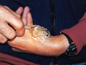
The critically endangered Pacific pocket mouse (Perognathus longimembris pacificus), once thought extinct was rediscovered at 4 sites along the coast of southern California during the 1990s. CBI staff discovered one of the populations and led comprehensive efforts to identify all potential habitat areas and inform efforts to recover the species from the brink of extinction. Tasks included:
1) Studying dispersal characteristics and other pertinent biological information on the species
2) Performing detailed field studies of a surrogate subspecies to perfect field methods and design monitoring programs
3) Determining the feasibility of a translocation or reintroduction program for the species, determining baseline measures of genetic diversity within and between extant (using live-captured specimens) and historic (using museum specimens) populations and developing genetic goals for the recovery program
4) Coordinating ongoing monitoring studies at extant population sites to maximize the value of the monitoring data for both scientific and preserve management goals
Partners include Transportation Corridor Agencies, U.S. Fish and Wildlife Service, and California Department of Fish and Game.
Photo credits: Steve Montgomery (juvenile above) and David King (1995, Camp Pendleton)
CBI provides scientific guidance for a wide variety of regional conservation plans, including:
- Habitat Conservation Plans (HCP)
- Natural Community Conservation Plans (NCCP)
- Endangered Species Recovery Plans
- Adaptive Management and Monitoring Plans
CBI staff organizes and facilitates panels of scientific experts and writes and edits science advisory reports that provide guidance for large-scale conservation plans. In California, these have included the Desert Renewable Energy Conservation Plan, the Sacramento-San Joaquin Bay Delta Conservation Plan, the Altamont Pass Wind Resource Area Conservation Plan, and NCCP/HCP plans for the counties of Butte, Santa Clara, San Diego, Merced, Yuba, Sutter, and Yolo, and the city of Santa Cruz.