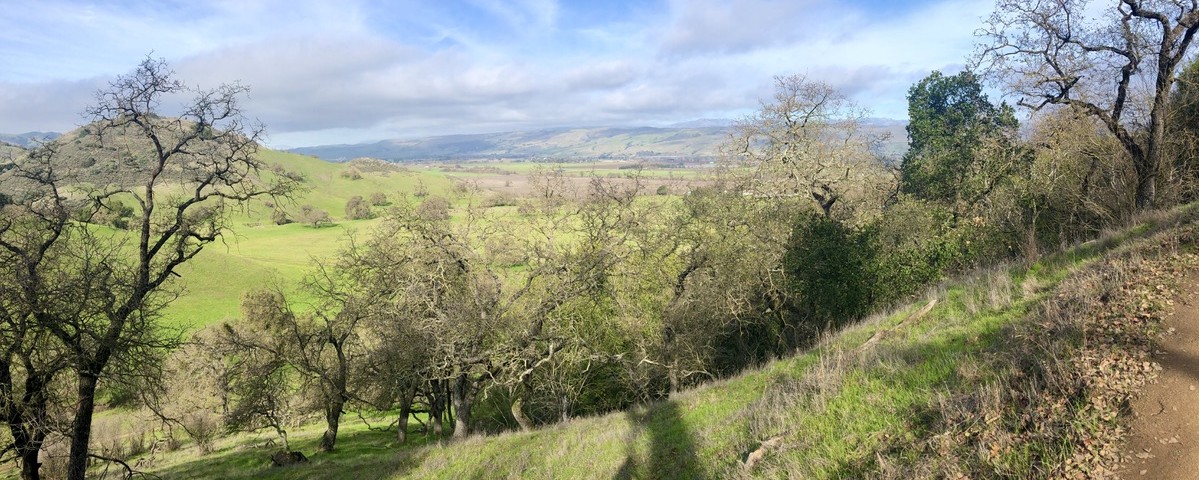
The Coyote Valley is a last chance landscape. The Valley, located within one of the world’s top 25 most important biodiversity hotspots, occurs on the south side of San Jose, California and is situated between the Santa Cruz Mountains and Diablo Range. The Santa Clara Valley Open Space Authority, in partnership with CBI, assembled a team of local and regional scientists with the goal of integrating existing scientific information and knowledge to develop a vision and practical plan for achieving a fully functional landscape linkage through the Valley to avoid isolating the two mountain ranges while protecting extremely important valley floor species and habitats. The plan includes restoration of important wetland and uplands habitats, support for numerous rare and sensitive species, and protection of important water and agricultural resources.
*Click here for the full report.
Conservation Biology Institute is working with the U.S. Forest Service and Oregon State University to develop the Climate Smart Restoration Tool (CSRT), an interactive web-based application that allows the user to match current seed sources with future climate conditions.
Natural resource managers must match the climatic adaptability of their seed sources to the climatic conditions of their restoration sites in order to better ensure successful long-term restoration outcomes. There is an urgent need to adopt climate-smart approaches to ecosystem management, but progress has been slow because landowners and natural resource managers lack readily available, site-specific information on which to act. Existing scientific information has been unavailable at the scale needed by natural resource managers and restoration practitioners.
The CSRT will be designed to (1) easily incorporate new scientific information (e.g., climate projections, physiological thresholds) and (2) allow users to select parameters of interest (e.g., climate change scenarios, and time periods). Climate associated with existing ecoregions and seed zones will be displayed so that natural resource managers can choose the appropriate seed source for their restoration site, or decide where seed from a particular source can be planted in the future. Managers will also be able to view spatial maps of current and future climate, seed zones, ecoregions, and other contextual map layers. The CSRT will provide the ability to download outputs of the tool to PowerPoint slides, PDF documents, and GeoTIFF files in order to share those results with others and perform additional analysis within desktop data processing environments.
Because of the uncertainty in climate change projections, the CSRT is primarily intended as a planning and educational tool. It can be used to explore alternative future conditions, assess risk, and plan potential responses. The tool allows the user to control many input parameters so the results are appropriate for the management practices, climate change assumptions, and risk tolerance of the user.
The CSRT will be implemented following the same method used to develop and publish the Seedlot Selection Tool (SST; https://seedlotselectiontool.org/sst/; Figure 1). We will develop a fully functional and widely available version of the CSRT using the latest open-source software and incorporating mechanisms for its long-term maintenance. We will work collaboratively with key stakeholders to ensure that the application is effective in meeting their needs, using a variety of mechanisms including webinars and targeted outreach.
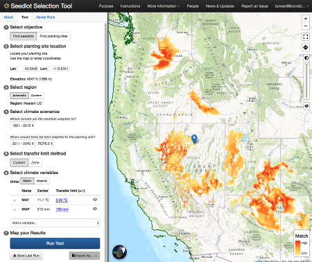
Screenshot of the Seedlot Selection Tool (SST), a forest-centric tool that helps natural resource managers match forest tree seed sources and climate conditions at planting sites.
A Regional Conservation Investment Strategy (RCIS) is a voluntary, non-regulatory, and non-binding conservation assessment that includes information and analyses relating to the conservation of focal species, their associated habitats, and the conservation status of the RCIS land base. The RCIS program, which is administered by the California Department of Fish and Wildlife, was created by state bill AB 2087. This conservation strategy is intended to guide conservation investments and advance mitigation in RCIS areas. CBI provided scientific and technical support to ICF International, who led the development of a pilot RCIS for the Antelope Valley in LA County. Implementation of this strategy is intended to sustain and enhance focal species and their habitats in the face of climate change and other stressors such as habitat loss and fragmentation.
Working with Oregon Department of Fish and Wildlife, Oregon Department of Transportation, US Fish and Wildlife Service, and other governmental and non-governmental partners, CBI is reviewing the current state of knowledge and is developing a wildlife and habitat connectivity blueprint for the State of Oregon, including the plan for generating a number of useful map-based products and online tools that will address planning at multiple scales across the state. This initial phase is expected to conclude in January 2018 with testing of the blueprint being carried out for a subset of the state (Coast Range and Klamath ecoregions) through different funding.
Conserved lands in southern San Diego County form the cornerstone of the San Diego Natural Community Conservation Planning (NCCP) network. This region supports the largest expanse of remaining coastal habitats in southern California—coastal sage scrub, maritime succulent scrub, chaparral, riparian woodlands, vernal pools, and grasslands. Intact landscapes are critical to genetic interchange within plant and animal populations and allow dispersal and recolonization of new areas. Large landscapes that span elevational gradients, such as this core area in south San Diego County, also enable populations to shift in response to environmental and land use changes.
State Route 94 (SR-94) cuts through the heart of this core area, potentially impeding wildlife movement across otherwise intact landscapes. New residential development and a casino under construction in Jamul will increase traffic and potentially impact the wildlife value and connectivity of adjacent conserved lands. Proposed road improvements associated with these new land uses provide an opportunity to mitigate the potential barrier effects of SR-94. Scientific literature suggests that strategically-placed wildlife fencing along roads, combined with effective wildlife crossing areas (e.g., undercrossings, overcrossings, bridges) are the most effective means of influencing animal behavior and directing animal movement, thereby reducing roadkill, enhancing connectivity, and improving traffic safety.
The purpose of this document is to provide available background information and connectivity objectives for multiple taxa that use this area and to identify potential infrastructure examples that could improve connectivity across the south county preserves. This document describes land uses, vegetation communities, and existing infrastructure along 12 miles of SR-94 and identifies potential locations, by road segment, where enhancements to existing undercrossings and additional fencing could facilitate wildlife movement across conserved lands. Because there are little wildlife movement data for this area, we outline wildlife movement studies and systematic collection of roadkill data that should begin now to inform and refine the actual design and placement of wildlife fencing and crossing structures. Once implemented, post-construction monitoring should be conducted to ensure that the new infrastructure is functional and cost-effective.
Working as a subcontractor to Dynamac Corporation, the Conservation Biology Institute provided the scientific leadership and technical support for two BLM Rapid Ecoregional Assessment (REAs). The Sonoran Desert ecoregion was completed in the spring of 2012. A series of conservation elements were chosen for the eocregion and over 40 management questions addressed. Most questions pertained to a listed set of change agents, including urban and agriculture development, energy (including renewables), fire, invasive species, recreation, and climate change. For each conservation element, conceptual models were created and, for each specific management question, an accompanying GIS-based process model was created that outlined the data and steps necessary to generate an answer to the question. Part of the project required an exhaustive acquisition and review of available spatial data – hundreds the ecoregion. Extensive and sophisticated modeling had to be applied to multiple topics including target species habitat, natural ecological systems, climate change, invasive species, wildfire, and landscape integrity. Also, some custom analytical software had to be generated throughout the course of the project.
Project review was conducted using Data Basin and final results reside in a private group space on this web-based data management and mapping system. To inquire about access to the data and map-based results, please contact Karen Prentice at BLM Headquarters (kprentice@blm.gov).
To download the report and find out more information, Click Here.
Working as a subcontractor to Dynamac Corporation, the Conservation Biology Institute provided the scientific leadership and technical support for two BLM Rapid Ecoregional Assessment (REAs). The Colorado Plateau ecoregion was completed in the spring of 2012. A series of conservation elements were chosen for the eocregion and over 40 management questions addressed. Most questions pertained to a listed set of change agents, including urban and agriculture development, energy (including renewables), fire, invasive species, recreation, and climate change. For each conservation element, conceptual models were created and, for each specific management question, an accompanying GIS-based process model was created that outlined the data and steps necessary to generate an answer to the question. Part of the project required an exhaustive acquisition and review of available spatial data – hundreds the ecoregion. Extensive and sophisticated modeling had to be applied to multiple topics including target species habitat, natural ecological systems, climate change, invasive species, wildfire, and landscape integrity. Also, some custom analytical software had to be generated throughout the course of the project.
Project review was conducted using Data Basin and final results reside in a private group space on this web-based data management and mapping system. To inquire about access to the data and map-based results, please contact Karen Prentice at BLM Headquarters (kprentice@blm.gov).
To download the full report and find our more information on the Colorado Plateau REA, click here.
The Puente-Chino Hills Wildlife Corridor is a peninsula of mostly undeveloped hills jutting about 42 km (26 miles) from the Santa Ana Mountains into the heart of the densely urbanized Los Angeles Basin. Intense public interest in conserving open space here has created a series of reserves and parks along most of the corridor’s length, but significant gaps in protection remain. These natural habitat areas support a surprising diversity of native wildlife, from mountain lions and mule deer to walnut groves, roadrunners, and horned lizards. But maintaining this diversity of life requires maintaining functional connections along the entire length of the corridor, so that wildlife can move between reserves—from one end of the hills to the other.
Already the corridor is fragmented by development and crossed by numerous busy roads, which create hazards and in some cases barriers to wildlife movement. Proposed developments threaten to further degrade or even sever the movement corridor, especially within its so-called “Missing Middle.” This mid-section of the corridor system, stretching from Tonner Canyon on the east to Harbor Boulevard on the west, includes several large properties proposed for new housing, roads, golf courses, and reservoirs. Such developments would reduce habitat area and the capacity to support area-dependent species and, if poorly designed, could block wildlife movement through the corridor.
This report builds on an impressive array of previous ecological and wildlife movement studies in the Puente-Chino Hills, as well as the general literature on wildlife movement corridors as it applies to this unique peninsula of wildness. It supplements the existing information with an analysis of gaps in protection—with special focus on the vulnerable Missing Middle—and recommends conservation and management actions to prevent further loss of ecological connectivity and retain native species.
The Klamath-Siskiyou ecoregion of southwest Oregon and northwest California has long been recognized for its global biological significance and is considered an Area of Global Botanical Significance by the World Conservation Union, a global Centre of Plant Diversity, and has been proposed as a possible World Heritage Site. More recently, World Wildlife Fund US scored the Klamath-Siskiyou as one of their Global 200 sites reaffirming its global importance from the standpoint of biodiversity.
CBI used GIS as the principle tool to assess the state of the environment in the Klamath-Siskiyou and to develop a reserve design proposal based on the three-tracks. GIS is a computer-based analytical mapping technology that is rapidly becoming the cornerstone for conservation planning at many different spatial scales.
The proposed work plan called for the analysis to be focused at the 1:100,000-map scale using the best available data. While the 1:100,000 remained our target planning scale, we incorporated larger scaled data (e.g., 1:24,000) wherever possible. Doing so allowed for much more meaningful and reliable analyses. One of the greatest challenges throughout this project was evaluating and integrating the various data layers acquired from numerous sources.
This project was a highly collaborative effort to identify and characterize areas important to maintaining a functional network of connected wildlands throughout the state of California. CBI worked with a team of planners, GIS modelers, and biologists, with input and guidance from numerous state, federal, and local agencies and stakeholders, to create three primary products:
(1) a statewide Essential Habitat Connectivity Map
(2) a database characterizing areas delineated on the map
(3) guidance for mitigating the fragmenting effects of roads and for developing and implementing local and regional connectivity plans
The essential connectivity network consists of relatively intact and well-conserved habitat areas (natural landscape blocks) that support native biodiversity and essential connectivity areas for maintaining wildlife movement and other ecological flows between them. The final report provides detailed guidance for considering ecological connectivity in transportation and land management planning, preparing finer-resolution regional and local connectivity plans and linkage designs, and siting and creating road-crossing improvements for wildlife to improve ecological connectivity and reduce vehicle-wildlife collisions. All products were produced using cutting-edge GIS modeling methods in a highly collaborative, transparent, and repeatable process that could be emulated by other states. The project was given the 2011 Exemplary Ecosystem Initiative Award by the Federal Highways Administration.
Please visit the California Essential Habitat Connectivity Project website