
Fire regimes result from reciprocal interactions between vegetation and fire that may be further affected by other disturbances, including climate, landform, and terrain. In this paper, we describe fire and fuel extensions for the forest landscape simulation model, LANDIS-II, that allow dynamic interactions among fire, vegetation, climate, and landscape structure, and incorporate realistic fire characteristics (shapes, distributions, and effects) that can vary within and between fire events. We demonstrate the capabilities of the new extensions using two case study examples with very different ecosystem characteristics: a boreal forest system from central Labrador, Canada, and a mixed conifer system from the Sierra Nevada Mountains (California, USA). In Labrador, comparison between the more complex dynamic fire extension and a classic fire simulator based on a simple fire size distribution showed little difference in terms of mean fire rotation and potential severity, but cumulative burn patterns created by the dynamic fire extension were more heterogeneous due to feedback between fuel types and fire behavior. Simulations in the Sierra Nevada indicated that burn patterns were responsive to topographic features, fuel types, and an extreme weather scenario, although the magnitude of responses depended on elevation. In both study areas, simulated fire size and resulting fire rotation intervals were moderately sensitive to parameters controlling the curvilinear response between fire spread and weather, as well as to the assumptions underlying the correlation between weather conditions and fire duration. Potential fire severity was more variable within the Sierra Nevada landscape and also was more sensitive to the correlation between weather conditions and fire duration. The fire modeling approach described here should be applicable to questions related to climate change and disturbance interactions, particularly within locations characterized by steep topography, where temporally or spatially dynamic vegetation significantly influences spread rates, where fire severity is variable, and where multiple disturbance types of varying severities are common.
Questions: To what extent do plant species traits, including life history, life form, and disturbance response characteristics, affect the degree to which species distributions are determined by physical environmental factors? Is the strength of the relationship between species distribution and environment stronger in some disturbance-response types than in others?
Location: California southwest ecoregion, USA.
Methods: We developed species distribution models (SDMs) for 45 plant species using three primary modeling methods (GLMs, GAMs, and Random Forests). Using AUC as a performance measure of prediction accuracy, and measure of the strength of species–environment correlations, we used regression analyses to compare the effects of fire disturbance response type, longevity, dispersal mechanism, range size, cover, species prevalence, and model type.
Results: Fire disturbance response type explained more variation in model performance than any other variable, but other species and range characteristics were also significant. Differences in prediction accuracy reflected variation in species life history, disturbance response, and rarity. AUC was significantly higher for longer-lived species, found at intermediate levels of abundance, and smaller range sizes. Models performed better for shrubs than sub-shrubs and perennial herbs. The disturbance response type with the highest SDM accuracy was obligate-seeding shrubs with ballistic dispersal that regenerate via fire-cued germination from a dormant seed bank.
Conclusions: The effect of species characteristics on predictability of species distributions overrides any differences in modeling technique. Prediction accuracy may be related to how a suite of species characteristics co-varies along environmental gradients. Including disturbance response was important because SDMs predict the realized niche. Classification of plant species into disturbance response types may provide a strong framework for evaluating performance of SDMs.
Greehouse gas emissions have significantly altered global climate, and will continue to do so in the future. Increases in the frequency, duration, and/or severity of drought and heat stress associated with climate change could fundamentally alter the composition, structure, and biogeography of forests in many regions. Of particular concern are potential increases in tree mortality associated with climate-induced physiological stress and interactions with other climate-mediated processes such as insect outbreaks and wildfire. Despite the risk, existing projections of tree mortality are based on models that lack functionally realitic mortality mechanisms, and there has been no attempt to track observations of climate-driven tree mortality globally. Here we present the first global assessment of recent tree mortality attributed to drought and heat stress. Although episodic mortality occurs in the absense of climate change, studies compiled here suggest that at least some of the world’s forested ecosystems already may be responding to climate change and raise concern that forests may become increasingly vulnerable to higher background tree mortality rates and die-off in response to future warming and drought, even in environments that are not normally considered water-limited. This further suggests risk to ecosystem services, including the loss of sequestered forest carbon and associated atmospheric feedbacks. Our review also identifies key information gaps and scientific uncertainties that currently hinder our ability to predict tree mortality in response to climate change and emphasize the need for a globally coordinated observation system. Overall, our review reveals the potential for amplified tree mortality due to drought and heat in forests worldwide.
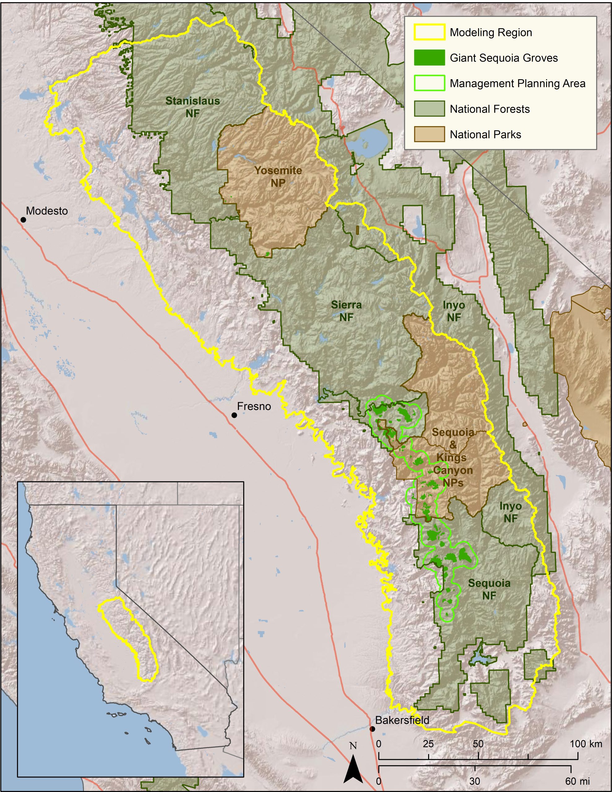
CBI will develop and apply a forest management decision-support system (DSS) for forest resilience planning in the southern Sierra Nevada that integrates the latest science on how vegetation, terrain, climate, and weather interact to influence fire risks and forest resilience. The interdisciplinary team led by CBI includes ecological modelers, forest ecologists, fire scientists, physicists, and statisticians. The core of the DSS will be a Forest Resilience Model built using EEMS (Ecosystem Evaluation Modeling System; Sheehan and Gough 2016). The DSS will be tested, refined, and applied to resilience planning in that portion of the modeling region of greatest concern to the interagency Sequoia Regional Partnership, which is working to restore ecologically resilient conditions in and near Sequoia National Forest and Sequoia-Kings Canyon National Park.
The resilience model evaluates forest resilience to fire, drought, and other factors based on landscape conditions. The DSS will allow managers to simulate fuel-reduction treatments, evaluate their effects on a range of risks and resources (e.g., fire, sequoias, fisher habitat), project the impacts into the future, and assess levels of uncertainty. The DSS and component models will help managers understand how, in concert with terrain and weather, vegetation structure influences fire behavior and forest resilience. Importantly, the DSS will for the first time consider how fire-atmosphere coupling affects fire in models to support forest planning. This will apply how vegetation structure influences fire via both fuel arrangements and air flows, and thus more accurately reflect the full picture of how vegetation treatments may affect fire and fire effects on the landscape.
The DSS will be further refined and applied to resilience planning by the Sequoia Regional Partnership, whose primary focus is reducing fire risks to giant sequoia groves, fishers, and human communities.
External Team members include: Joe Werne (NorthWest Research Associates NWRA), Christopher Wikle (Department of Statistics, University of Missouri) and David Marvin (SALO Science).
 Map of project study area.
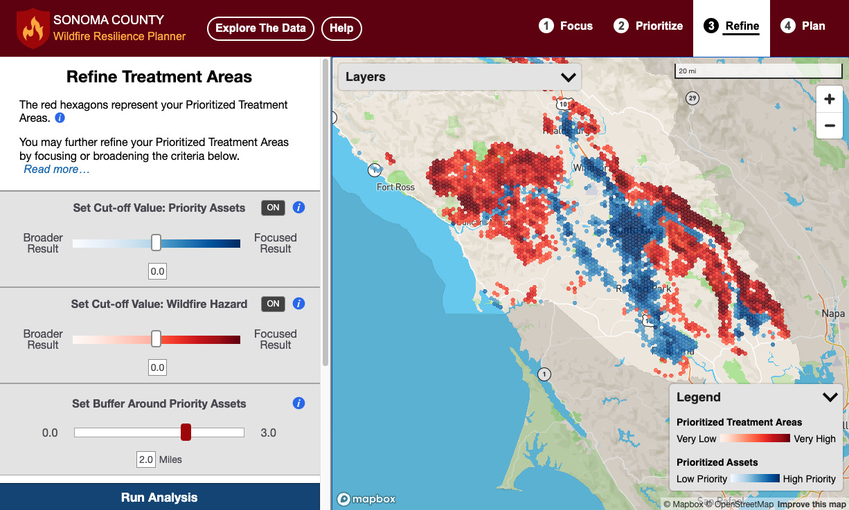
Efforts are underway in Sonoma County to provide critical information to facilitate strategic, ecologically-sensitive fuel management across the region for the long-term resilience of its communities and watersheds. The Sonoma County Wildfire Resilience Decision Support Framework is part of a county-wide coordinated initiative to prioritize actions and investments by local agencies implementing the Sonoma County Community Wildfire Protection Plan.
Two online decision-support tools make up the Decision Support Framework:
The Wildfire Resilience Planner: Strategic Planning at the Landscape Scale
Sonoma Water, Conservation Biology Institute (CBI), Ag Innovations, Pepperwood Preserve, Tukman Geospatial, Digital Mapping Solutions have created the Sonoma County Wildfire Resilience Planner, an online decision support tool for prioritizing locations to reduce wildfire fuels to protect lives and property, community infrastructure, ecosystem services, and biodiversity. The tool encourages collaborative planning of projects on public and private land, helping to leverage individual efforts for a unified and strategic approach to fuels management. The Wildfire Resilience Planner is available for use at https://sonoma.resilienceplanner.org/. For more information or to provide feedback, please contact Molly Oshun, Molly.Oshun@scwa.ca.gov or Deanne DiPietro, deanne.dipietro@consbio.org.
The Wildfire Fuel Mapper: Property-Specific Information for Fuels Management
The University of California Cooperative Extension, Pepperwood Preserve, and Tukman Geospatial have developed the Wildfire Fuel Mapper, on online tool that provides landowners and managers with maps and information for designing and implementing projects to reduce wildland fuels. For more information contact Stephanie Larson slarson@ucanr.edu or Kai Foster kfoster@pepperwoodpreserve.org.

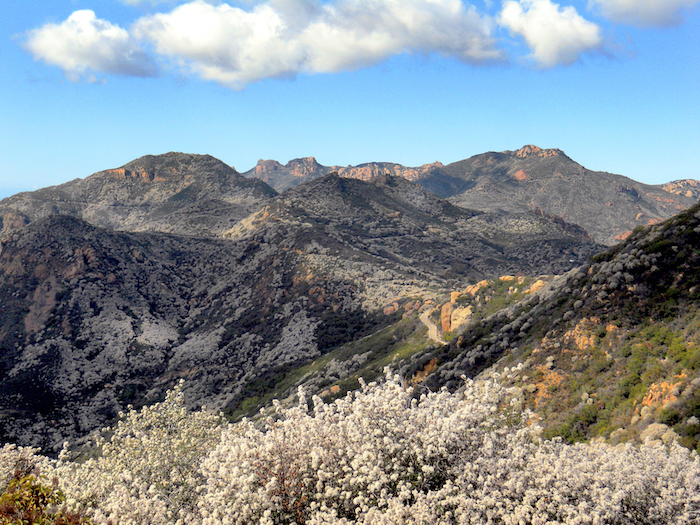
Conservation Biology Institute and the Resource Conservation District of the Santa Monica Mountains are working in partnership with local land management agencies and communities to increase wildfire resilience in the Santa Monica Mountains region. The Program has the following tasks:
Raising awareness about wildfire risk in the local communities
- Providing Home Ignition Zone Evaluations to help homeowners reduce their fire risk. If you are interested in having your home evaluated, or getting trained to do evaluations in your neighborhood, contact the RCD SMM.
- Surveying residents about their knowledge of wildfire risk and what they can do to reduce it. Here are the results of the 2021 Survey, and you can take the 2022 Santa Monica Mountains Wildfire Preparedness Survey here.
Helping homeowners prepare for wildfire
- The program provides assistance to homeowners to reduce their wildfire susceptibility by removing hazard trees and restoring burned landscapes to buffer neighborhoods from wildfire
- Learn more about home hardening and ecologically-appropriate defensible space techniques at http://defensiblespace.org.
Mapping and planning the control of flammable invasive weeds in the Woolsey Fire footprint
- The program and its partners Santa Monica Mountains National Recreation Area, Santa Monica Mountains Conservancy, and California State Parks have contracted with Wildlands Conservation Science to conduct aerial surveys to map invasive plant species in the public lands of the Santa Monica Mountains to inform land management to increase future public safety and wildfire preparedness.
- The data and a comprehensive weed control plan will be available by the end of 2023.
Modeling and research to inform planning and decision making
- Program partner U.S. Forest Service Missoula Fire Sciences Lab is modeling ember transport at the property scale under different defensible space conditions. Results of this study will be available in early 2023.
- Conservation Biology Institute conducted ignition and large fire probability modeling to help prioritize locations for risk reduction. See these results here: Wildfire Ignition Potential and Large Wildfire Potential models. You may also see this Wildfire Model Comparison for SMM Region to compare and get access to other important fire risk and hazard maps.
The Santa Monica Mountains Woolsey Fire Recovery and Adaptation Program is funded by the National Fish and Wildlife Foundation.
As the Sierra Nevada town of Paradise rebuilds after the devastating Camp Fire of 2018, the community has an opportunity to incorporate strategies to increase its resilience to fire and climate change, enhance the safety and well-being of its residents, and at the same time care for the surrounding natural areas that make it a beautiful place to live.
CBI and the The Nature Conservancy helped Paradise seize this opportunity when the Paradise Recreation and Park District asked us to help them explore community design principles that could provide all of these benefits. The CBI team created geographic models of “Wildfire Risk Reduction Buffers” between the structures and the surrounding wildlands to reduce exposure of homes to wildfire risks. These buffers, which can be made up of parklands, orchards, and other low fire-risk land uses, can be managed to provide many benefits, including buffering homes from ignition, providing safe-haven refuges for residents to escape from fire, strategically-placed staging areas for fire-fighters, recreational access to open space, and protecting natural habitat from the effects of an encroaching urban landscape.
The team combined spatial data about the landscape with local knowledge to prioritize locations for fire risk-reduction and analyzed ignition risks and co-benefits with and without the buffers. The resulting maps illustrate the potential for local partnerships to make a real difference in the town’s future. Through innovative thinking about the role of land use planning, the community of Paradise is changing its approach to living with fire and providing a model for fire-prone communities everywhere.
CBI is working in collaboration with Oregon State University, the University of Minnesota, and the University of Colorado Boulder on a project designed to help improve our understanding of post-fire community resilience. Central to the project will be the development of an RFID sensor network which will help support post-fire assessments of water infrastructure damage. These sensors will be deployed across a community’s freshwater pipeline network and will transmit data (e.g., temperature reached, pipeline material, exposure duration) that will help determine whether or not toxins have started leaching from the pipes into the freshwater supply. The current phase of the project focuses on Santa Rosa and Paradise in California where the 2017 Tubbs Fire and the 2018 Camp Fire caused damage to the water distribution systems, resulting in contaminated water within the system.
To help support this effort, CBI has developed a web application called the Wildfire Vulnerability Explorer, which can be accessed at https://wildfirevulnerability.eemsonline.org. This application allows users to explore a set of spatially explicit models developed for Santa Rosa and Paradise that identify areas likely to be vulnerable to water contamination exposure following a large-scale fire event. Estimates of vulnerability are based on three primary factors: the probability of water contamination, socioeconomic sensitivity, and adaptive capacity. The Wildfire Vulnerability Explorer brings this information together in an interactive map in order to help officials with both pre-fire planning and post-fire prioritization of recovery efforts – by identifying communities that are the most vulnerable to water contamination exposure, efforts can be taken to better plan for and direct resources to those areas.
Additional information about the project is available on the OSU project page at the link below:
Sensor Technology for Improved Wildland Urban Interface (WUI) Fire Resilience
Funding for the project was provided by the Alfred P. Sloan Foundation.
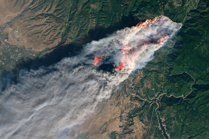
Photo courtesy of NASA (https://earthobservatory.nasa.gov/images/144225/camp-fire-rages-in-california): Camp Fire in Paradise, California, which is one of the project study areas.
The need to plan strategic, effective forest management is urgent in the southern Sierra Nevada, where forests have been ravaged by drought, fire, and catastrophic tree mortality. Multiple, sometimes conflicting, management objectives must be balanced, and multiple agencies need help coordinating their forest restoration actions. A common, readily accessible system evaluating landscape-scale forest condition is needed.
Conservation Biology Institute is working with the Sierra Nevada Conservancy, Sequoia National Forest, Sequoia National Parks, Sequoia Parks Conservancy, Save the Redwoods League, and others to develop forest resilience models and create a toolkit for exploring these data to support the planning of a range of resource management goals. These goals include the protection of sequoia groves, overall forest health, wildfire protection, and endangered species habitat management. The project is supported by CBI’s data sharing and mapping platform Data Basin. The project is funded by the Save the Redwood League and Sequoia National Park through its partner the Sequoia Parks Conservancy, and CAL FIRE Forest Health Research Grant Program.
Cachuma Resource Conservation District (RCD) is working in partnership with Conservation Biology Institute, LegacyWorks, and Sharyn Main Consulting on the Regional Priority Plan to Reduce Wildfire Risk and Improve Forest Health in Santa Barbara County (RPP), which is a flagship project of the Santa Barbara County Conservation Blueprint. Funded by the California Coastal Conservancy, the RPP helps with the planning, mapping, and prioritization of projects that will proactively address wildfire threat in Santa Barbara County, as well as improve forest and habitat health.
The RPP is a multi-prong collaboration, which focuses on public and private land in the wildland/urban interface (WUI). CBI is the lead for a component of the project, to develop a sophisticated decision-support mapping tool to not only predict areas of high fire-risk on a landscape scale, but also help the community prioritize where fire risk mitigation projects should occur. The tool will serve as a community resource within the Santa Barbara County Conservation Blueprint and should improve communication, network building, and support community priorities through a regional approach to fire resilience and habitat health. The project team is talking with the many agencies and stakeholders involved, and facilitating the collaborative decision-making process.