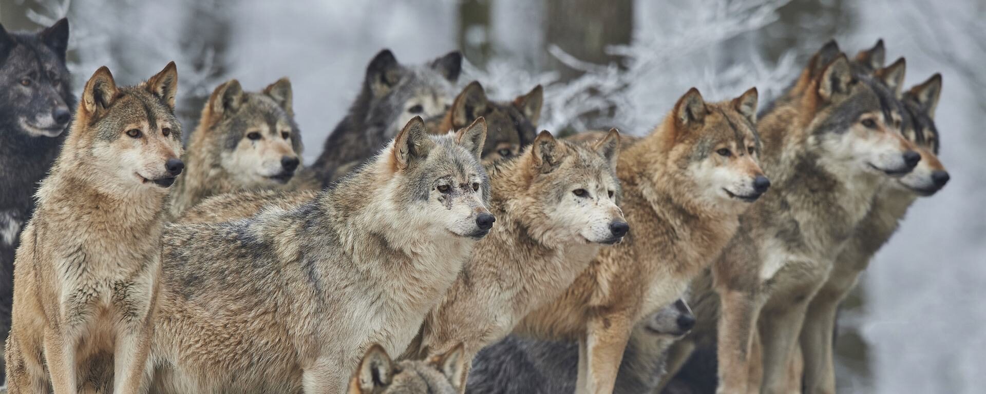
Wolves were extirpated from the Adirondacks over a century ago due largely to human eradication efforts. The Conservation Biology Institute (Corvallis, OR) was chosen by the Adirondack Citizens Advisory Committee to examine the question of biological feasibility of reintroducing gray wolves back to the Adirondacks. By applying what is known about gray wolf ecology (in general) to the best available spatial and genetics data for the Adirondacks, we examined three basic questions:
- Is there suitable gray wolf habitat in the Adirondacks to support a viable population?
- Is there adequate landscape connectivity both within the Adirondacks and between the Adirondacks and the surrounding region to allow for reasonable gray wolf movement important to their persistence?
- What does the most recent genetics tell us about wolves in the Adirondacks?
The Klamath-Siskiyou ecoregion of southwest Oregon and northwest California has long been recognized for its global biological significance and is considered an Area of Global Botanical Significance by the World Conservation Union, a global Centre of Plant Diversity, and has been proposed as a possible World Heritage Site. More recently, World Wildlife Fund US scored the Klamath-Siskiyou as one of their Global 200 sites reaffirming its global importance from the standpoint of biodiversity.
CBI used GIS as the principle tool to assess the state of the environment in the Klamath-Siskiyou and to develop a reserve design proposal based on the three-tracks. GIS is a computer-based analytical mapping technology that is rapidly becoming the cornerstone for conservation planning at many different spatial scales.
The proposed work plan called for the analysis to be focused at the 1:100,000-map scale using the best available data. While the 1:100,000 remained our target planning scale, we incorporated larger scaled data (e.g., 1:24,000) wherever possible. Doing so allowed for much more meaningful and reliable analyses. One of the greatest challenges throughout this project was evaluating and integrating the various data layers acquired from numerous sources.
CBI conservation biologists Jerre Stallcup, Patricia Gordon-Reedy, and Jessie Vinje are working with the San Diego National Wildlife Refuge (NWR), U.S. Bureau of Land Management (BLM), and California Department of Fish and Wildlife (CDFW) to develop methods for restoring grasslands of historic ranchos in southern San Diego County. Together, we will develop an adaptive management plan with the objective of replicating this process on other conserved lands in southern California.
In the early to mid-1990s the Otay-Sweetwater area of San Diego County was comprised mostly of large cattle ranches; these were formerly Mexican land grants established in the early 1800s. Because of their size, resources, and location near large public land holdings of BLM and CDFW, these properties were excellent candidates for acquisition as part of the San Diego Multiple Species Conservation Program (MSCP), a proactive and ecosystem-based conservation initiative launched in 1991 and continuing today. However, the properties also held special appeal to developers for many of the same reasons.
The San Diego NWR was thus born from unprecedented cooperation and partnership among local, state, and federal agencies, developers, and private conservation groups. This area, where CBI is now working, lies within the largest expanse of undeveloped land in the MSCP planning area, supporting some of the last remaining coastal habitats of southern California. Because of the concentration and global significance of its sensitive habitats and endangered species, and its high habitat integrity and proximity to other conserved lands, this unfragmented landscape is one of the highest priorities for conservation in California.
CBI used detailed habitat assessments and conceptual models to design cost-effective ways of controlling exotic grasses to benefit targeted grassland species (Otay tarplant, Quino checkerspot butterfly, and burrowing owl), testing different mechanical and chemical methods informed by past management practices. We will restore native grasslands and forblands suitable for these and other rare species. Coordination among land managers will allow us to conserve costs through economies of scale in contracting and implementing multi-year management actions with the objective of expanding the coverage of management actions based on the results of this project.
This project is providing spatially explicit scientific foundations for forest management recommendations to sustain and enhance populations of four imperiled carnivores in the Sierra Nevada of California: marten (Martes americana), fisher (Martes pennanti), wolverine (Gulo gulo), and Sierra Nevada red fox (Vulpes vulpes necator). The recommendations focus on enhancing resiliency of existing populations over the next 15-20 years, and assessing strategies for adaptation to climate change in the longer term.
Products include maps depicting habitat value and distribution for each species, lands important to maintaining population connectivity and movement potential between habitat areas, and lands important to accommodating shifts in distribution under climate change. These maps will serve as foundations for spatially explicit conservation, management, and restoration recommendations, which can be incorporated into National Forest Management Plans and other land use and management plans.
This project will produce decision-support maps and tools to support an Interagency Fisher Biology Team in developing and implementing a Conservation Strategy for the west coast fisher Distinct Population Segment (DPS)–a Candidate for listing under that Endangered Species Act that stretches from southern British Columbia through Oregon, Washington, and California. The Interagency Fisher Team includes representatives of the US Fish and Wildlife Service, US Forest Service, and other Federal, State, and Provincial agencies with an interest in species conservation and forest management.
CBI will prepare maps, analyses, and other decision-support tools, including habitat value, habitat connectivity, and population distribution maps for the DPS under current conditions, and an assessment of climate-change effects on fisher habitat and populations in the future. These types of spatially explicit decision-support tools are needed to inform conservation planning and adaptive management to sustain and restore habitat value and fisher populations within the fisher DPS.
This report assesses potential impacts of feral pig populations in southern California (San Diego, Riverside, Imperial, and Orange counties) and Baja California, with an emphasis on San Diego County. We compiled information on the status of pigs in these areas from the literature and interviews with numerous individuals knowledgeable about feral pig populations, including a population recently introduced into San Diego County. We also reviewed available information on the potential impacts of feral pigs on natural resources, water systems, agriculture, and human health, and discussed the feasibility of various control and eradication options.
We developed population and habitat suitability models for feral pigs in San Diego County to examine the potential for numeric and geographic expansion following the recent introduction near El Capitan Reservoir. The models suggest that the population has the potential to grow rapidly and expand into large expanses of currently unoccupied habitat. Such expansion could harm natural biological resources, including riparian and oak woodland communities and numerous sensitive species. It is possible that populations could establish in such protected lands as Cuyamaca Rancho State Park and Volcan Mountain Preserve, as well as various wilderness areas. This could greatly diminish and possibly nullify large conservation investments already made in this region, including habitat restoration efforts. Finally, an expanding feral pig population in San Diego County could invade and cause grave damage in Baja California, where feral pig populations have not, to date, been reported.
In response to the environmental consequences of burning fossil fuels, particularly climate change, and rising energy prices, alternative energy sources are being actively sought throughout the world. Renewable energy sources can help to meet growing energy demands while reducing environmental costs. One widely promoted alternative is biomass energy derived from dedicated biomass crops, as well as from forest and fire management activities. While biomass energy shows some promise as a clean, renewable, and domestic alternative to fossil fuels, it can conflict with critical ecological values and sustainability goals if not properly planned for and implemented. In order to move toward ecological sustainability, biomass energy production must not degrade these important ecological values. However, existing projections of available forest and shrubland biomass resources in the U.S. have not adequately taken these values into consideration.
The Natural Resources Defense Council (NRDC) commissioned CBI to evaluate the effect that ecological constraints would have on estimates of forest and shrubland biomass resources available for energy production in California, as assessed by the California Energy Commission in 2005. California, home to many biologically diverse and unique areas, has been a leader in developing biomass as a potential source of energy as the demand for electrical power continues to rise. The current contribution from biomass to electrical power in California is very small, but current and future biomass resources could be effectively developed to contribute as much as 15 percent of electrical energy demands by 2020. Rapid development of biomass as an energy alternative in California and elsewhere without careful consideration of the overall environmental impact could help achieve climate change abatement goals on the one hand but devastate important biological and ecological values on the other. Accounting for these effects is an initial step towards reducing the environmental impact and risk to important conservation values as biomass development planning and implementation moves ahead. Using available spatial datasets, CBI’s GIS-based analysis quantified and mapped the changes to the current forest and shrubland biomass estimates after accounting for ecological values, such as old growth forest and critical habitat, and the wildland-urban interface.
The Conservation Biology Institute, through a grant from the David and Lucille Packard Foundation, is working with BLM, CDFG, and USFWS to develop a science-based regional planning framework for the high wind resource region of the eastern Tehachapi Mountains and southeastern Sierra. The project is intended to facilitate decision-making on a regional basis, per the recent federal guidance policies, through spatially-explicit and transparent decision-support tools for wind energy development and conservation.
We assembled available spatial datasets related to biodiversity and landscape intactness, developed logic and associated thresholds, and ranked sections of land (640 acres/1 Sq. mile), according to ecological value, biological potential, and level of disturbance. CBI has created web-based tools for visualizing the results, which are transparent, flexible, and supportive of agency needs. The results are being used to map priority areas for conservation and where renewable energy projects and associated infrastructure may be compatible with conservation goals.
Implemented for the Southern Sierra/Western Mojave, the approach and decision-support tool have widespread applicability, including:
- Informing conservation goals
- Setting priorities for regional reserve design and off-set mitigation
- Informing resource management needs
- Identifying priority information gaps
- Prioritizing conservation of unprotected lands
- Providing a process for transparent risk assessments by developers and permit agencies
- Identifying potential conflicts with development
The title of this project was formerly “Wind, Wings & Wilderness”
Click here for the final project report.
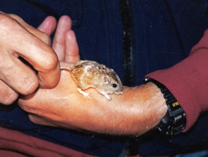
The critically endangered Pacific pocket mouse (Perognathus longimembris pacificus), once thought extinct was rediscovered at 4 sites along the coast of southern California during the 1990s. CBI staff discovered one of the populations and led comprehensive efforts to identify all potential habitat areas and inform efforts to recover the species from the brink of extinction. Tasks included:
1) Studying dispersal characteristics and other pertinent biological information on the species
2) Performing detailed field studies of a surrogate subspecies to perfect field methods and design monitoring programs
3) Determining the feasibility of a translocation or reintroduction program for the species, determining baseline measures of genetic diversity within and between extant (using live-captured specimens) and historic (using museum specimens) populations and developing genetic goals for the recovery program
4) Coordinating ongoing monitoring studies at extant population sites to maximize the value of the monitoring data for both scientific and preserve management goals
Partners include Transportation Corridor Agencies, U.S. Fish and Wildlife Service, and California Department of Fish and Game.
Photo credits: Steve Montgomery (juvenile above) and David King (1995, Camp Pendleton)