The National Conservation Easement Database (NCED) is the first national database of conservation easement information, compiling records from land trusts and public agencies throughout the United States. This public-private partnership brings together national conservation groups, local and regional land trusts, and state and federal agencies around this common objective.
The purpose of the NCED project is to, in collaboration with land trusts and public agencies, create a single, up-to-date, sustainable nationwide system for managing and accessing data about conservation easements. Five leading conservation organizations have joined forces to develop the NCED:
- Conservation Biology Institute
- Defenders of Wildlife
- Ducks Unlimited
- NatureServe
- Trust for Public Land
Key partners providing support, advice, and data include the Land Trust Alliance, representing the views and concerns of the nation’s 1,700+ local and regional land trusts, The Nature Conservancy, the U.S. Fish and Wildlife Service, the Natural Resources Conservation Service, and the U.S. Forest Service.
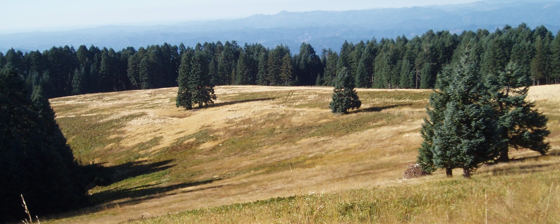
The fisher (Martes pennanti) is a large member of the weasel family associated with dense, structurally complex, low- to mid-elevation forests. Remaining populations in the western U.S. are small, disconnected from one another, and threatened by habitat modification and fragmentation. In 2008 fishers occupied less than half their historic range, having apparently been extirpated from the central and northern Sierra Nevada. A small population persist in the southern Sierras, south from Yosemite National Park to the vicinity of the Greenhorn Mountains in southern Tulare County.
The Conservation Biology Institute (CBI) was commissioned by Region 5 of the U.S. Forest Service to compile all available data on fisher populations and habitat in the southern Sierra Nevada, assess their current status, and predict how they are likely to respond to various alternative forest management actions, as well as unmanaged events such as wildfires, drought, or bark beetle outbreaks. The project was designed to create a scientifically credible set of habitat maps and estimates of fisher population size and distribution in the southern Sierra Nevada based on current conditions and likely future change under a range of alternative scenarios.
A group of independent science advisors was assembled to oversee the technical aspects of the analysis and ensure use of best available science. Stakeholder groups were kept informed via stakeholder representatives from the timber industry, conservation organizations, the US Fish and Wildlife Service, California Department of Fish and Game, and the various National Parks and Forests in the studya are. CBI worked closely with experts from the Pacific Southwest Reserach Station and Region 5 to ensure that the analysis accurately reflected proposed forest management actions.
The Conservation Biology Institute, through a grant from the David and Lucille Packard Foundation, is working with BLM, CDFG, and USFWS to develop a science-based regional planning framework for the high wind resource region of the eastern Tehachapi Mountains and southeastern Sierra. The project is intended to facilitate decision-making on a regional basis, per the recent federal guidance policies, through spatially-explicit and transparent decision-support tools for wind energy development and conservation.
We assembled available spatial datasets related to biodiversity and landscape intactness, developed logic and associated thresholds, and ranked sections of land (640 acres/1 Sq. mile), according to ecological value, biological potential, and level of disturbance. CBI has created web-based tools for visualizing the results, which are transparent, flexible, and supportive of agency needs. The results are being used to map priority areas for conservation and where renewable energy projects and associated infrastructure may be compatible with conservation goals.
Implemented for the Southern Sierra/Western Mojave, the approach and decision-support tool have widespread applicability, including:
- Informing conservation goals
- Setting priorities for regional reserve design and off-set mitigation
- Informing resource management needs
- Identifying priority information gaps
- Prioritizing conservation of unprotected lands
- Providing a process for transparent risk assessments by developers and permit agencies
- Identifying potential conflicts with development
The title of this project was formerly “Wind, Wings & Wilderness”
Click here for the final project report.
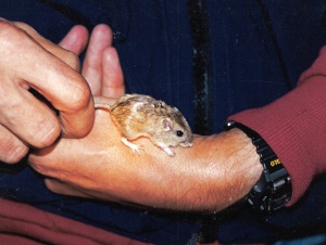
The critically endangered Pacific pocket mouse (Perognathus longimembris pacificus), once thought extinct was rediscovered at 4 sites along the coast of southern California during the 1990s. CBI staff discovered one of the populations and led comprehensive efforts to identify all potential habitat areas and inform efforts to recover the species from the brink of extinction. Tasks included:
1) Studying dispersal characteristics and other pertinent biological information on the species
2) Performing detailed field studies of a surrogate subspecies to perfect field methods and design monitoring programs
3) Determining the feasibility of a translocation or reintroduction program for the species, determining baseline measures of genetic diversity within and between extant (using live-captured specimens) and historic (using museum specimens) populations and developing genetic goals for the recovery program
4) Coordinating ongoing monitoring studies at extant population sites to maximize the value of the monitoring data for both scientific and preserve management goals
Partners include Transportation Corridor Agencies, U.S. Fish and Wildlife Service, and California Department of Fish and Game.
Photo credits: Steve Montgomery (juvenile above) and David King (1995, Camp Pendleton)
CBI provides scientific guidance for a wide variety of regional conservation plans, including:
- Habitat Conservation Plans (HCP)
- Natural Community Conservation Plans (NCCP)
- Endangered Species Recovery Plans
- Adaptive Management and Monitoring Plans
CBI staff organizes and facilitates panels of scientific experts and writes and edits science advisory reports that provide guidance for large-scale conservation plans. In California, these have included the Desert Renewable Energy Conservation Plan, the Sacramento-San Joaquin Bay Delta Conservation Plan, the Altamont Pass Wind Resource Area Conservation Plan, and NCCP/HCP plans for the counties of Butte, Santa Clara, San Diego, Merced, Yuba, Sutter, and Yolo, and the city of Santa Cruz.
CBI staff are leading a large team of mammal experts in preparing a comprehensive review of the conservation status of all mammal species, subspecies, and distinct population segments in California. The team has developed and applied a systematic scoring procedure to rank mammal species, subspecies, or distinct population segments for their relative degree of conservation concern within California. They compiled all available locality data and other pertinent information concerning the status and distribution of nominee taxa, and are preparing species accounts and geographic range maps for each taxon that made the final list. The result will be used to update Department of Fish and Game’s official list of sensitive taxa and will be published in book and web formats.
Click here to access the Mammal Species of Special Concern (MSSC) website
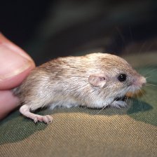
Photo credit: Steve Montgomery
CBI staff verified a new population of the endangered Stephens’ kangaroo rat in the Santa Maria Valley, San Diego County, California, by trapping and reconnaissance surveys and performed numerous adaptive management and monitoring tasks to help sustain this isolated population. Tasks included:
- Mapping the density and extent of population
- Performing GIS habitat modeling to predict other potential habitat in the region
- Providing tissue samples for genetic analyses, which demostrated that the population is unique and highly inbred
- Preparing a Biological Assessment for the expansion of the Ramona Airport in the heart of the population and a Habitat Management Plan to sustain the population via adaptive management and monitoring
- Preparing and implementing a translocation program to salvage kangaroo rats prior to construction of an expanded airport runway through the heart of the population, house them in captivity, release them to improved habitat areas, and monitor success of the translocated population and the overall population in the area for several years