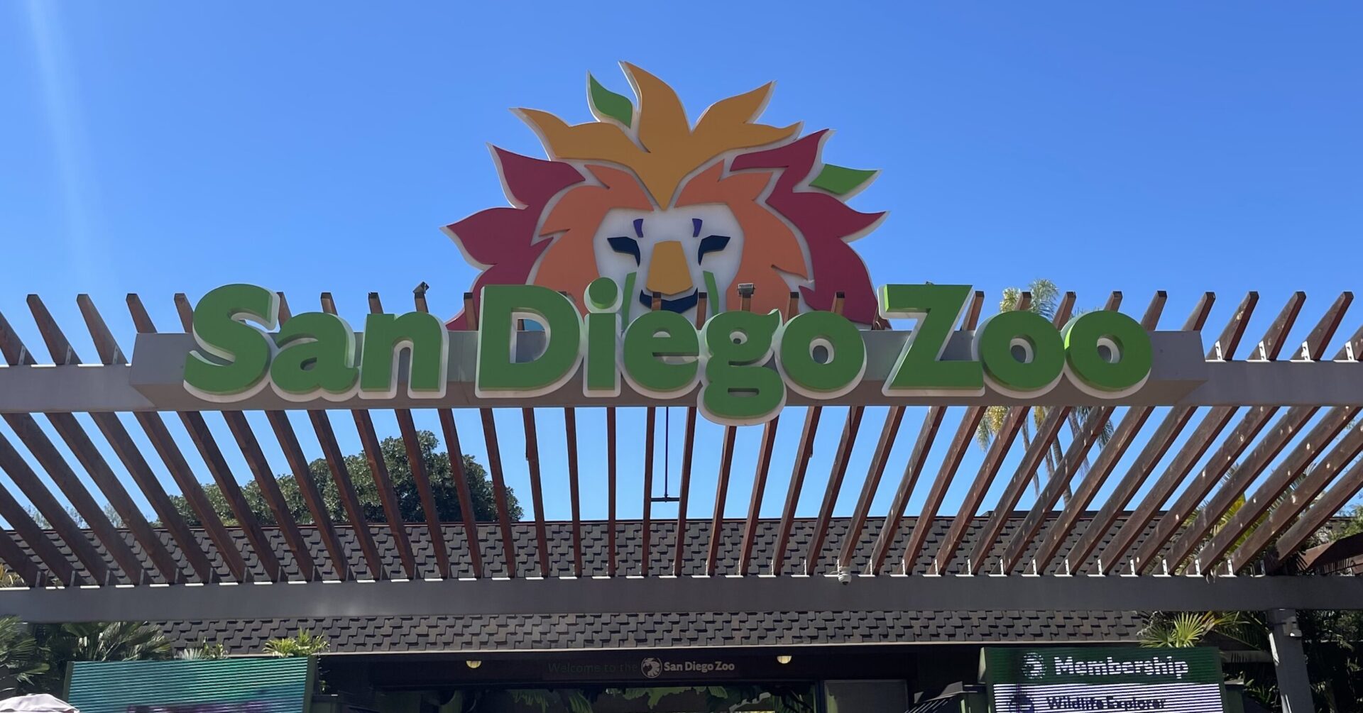
The San Diego Zoo Wildlife Alliance (SDZWA) is a world-renowned conservation organization with a 1800-acre zoo, the Safari Park, that houses more than 2600 animal and 3500 plant species. Located in Escondido (northern San Diego County), the Safari Park also includes a 800-acre biodiversity preserve with some of the most well-preserved, California-endemic coastal sage habitat.
In 2007, the Witch fire burned through 600 acres of the biodiversity reserve and stopped just outside the Safari Park borders. Since then, the SDZWA has transformed their in-house wildfire preparedness program, including hiring a team of dedicated wildfire suppression staff, fire suppression equipment boxes scattered throughout the park, an infrared and visible spectrum camera array for early ignition detection, and a 8500-gallon water tank for aerial suppression by local first responders.
While these investments in wildfire readiness are important for protecting the Safari Park grounds, landscape-scale risk analyses are needed to determine where fires may start and spread outside of park boundaries and which additional management activities could mitigate risk from fires originating beyond Park borders. Conservation Biology Institute (CBI) and Dudek have proposed to co-create the needed wildfire risk analysis for the SDZWA Safari Park.
At the core of the risk analysis is a fusion and comparison between two commonly employed modeling efforts used in
CBI is a partner in producing a statewide wildlife connectivity ensemble model and associated mapped data in support of a connectivity action plan for the state, which is under development. The modeling will identify priority areas across the state in need of some form of mitigation to promote wildlife connectivity and reduce wildlife/vehicle collisions at the same time. The co-production process includes the close collaboration with an active Technical Advisory Group. The project is being funded by the Washington Department of Fish and Wildlife.
The Giant Sequoia Lands Coalition (GSLC) is a collaboration of public and non-governmental organizations committed to the conservation of giant sequoia grove ecosystems. CBI is supporting the GSLC’s Sequoia Grove Protection and Resiliency Project with tools and assistance that will enable GSLC partners and stakeholders to work collaboratively to protect the species from the impacts of drought, beetles, and wildfire made more intense by climate change.
CBI is using its Data Basin platform (databasin.org) to host the Giant Sequoia Data Portal. The portal will be populated with custom maps of the sequoia groves linked to standard metrics and data for assessing grove condition, fuel treatments, and other range-wide information. To inform this giant sequoia management “dashboard” CBI is working with the GSLC to catalog an extensive collection of assessment, monitoring, and remote sensing datasets created by different agencies and projects over many decades of forest management and research. CBI will train and support the GSLC partners in their use of the Giant Sequoia Data Portal for promoting coordinated scientific research, monitoring, long-term species conservation, and continuing to share new data as it becomes available.

In the 1850s, immigrants seeking gold in California’s Sierra Nevada mountains created a connected network of open channels, wooden flumes, and pipes to direct water to their operations and the rapidly-growing foothill towns of Sonora, Columbia, and Jamestown.
170 years later, this historic system is an integral part of the water infrastructure that supports residential, agricultural, hydroelectric, ecosystem, and recreational purposes, providing nearly all of the drinking water to the west slope communities of Tuolumne County. Tuolumne Utilities District (TUD), the agency responsible for managing the 70-plus miles of raw water ditches and potable water infrastructure, is contending with a modern-day concern: the threat of severe wildfire.
Conservation Biology Institute and EN2 Resources, Inc. (en2resources.com/) partnered to develop the TUD Wildfire Defense Plan, which was adopted by Tuolumne Utilities District (TUD) in April of 2025.
This comprehensive strategy to protect Tuolumne County’s water resources and increase the community’s resilience to wildfire aligns with and implements the Tuolumne County Community Wildfire Protection Plan (CWPP). This plan also follows state and federal government directives relating to wildfire resilience for California’s communities and forests, including the California Wildfire and Forest Resilience Task Force’s Wildfire and Forest Resilience Action Plan and the U.S. Forest Service’s Wildfire Crisis Strategy Implementation Plan.
The TUD Wildfire Defense Plan contains two components:
TUD Wildfire Risk Mitigation Plan, prepared by CBI in consultation with TUD, presents prioritized locations for mitigating wildfire risks to TUD infrastructure and supports the effective planning and implementation of the prioritized projects while providing co-benefits to the community and natural resources.
The TUD Fire Water Draft Points Plan, prepared by EN2 Resources in consultation with TUD, identifies 49 strategic raw water draft points across the district to increase water availability for fire suppression, reduce demands on potable water systems, and enhance emergency response capabilities.Together these plans will help TUD manage the system as “green infrastructure”, a vision that addresses the integrated needs of people, the communities, and biodiversity under climate change. TUD, together with Pacific Gas & Electric, the US Forest Service, CAL FIRE, Tuolumne County, Tuolumne Fire Safe Council and the Tuolumne Band of Me-Wuk Indians are already working intensively to reduce fuels in the region, and this Plan will assist the agency in obtaining the funding needed to continue this important work.
The TUD Wildfire Defense Plan was developed with funding from the USDA Forest Service Community Wildfire Defense Grant. For more information about the TUD Wildfire Defense Plan, please visit https://tudwater.com/wildfire-defense-plan/.
The USDA Conservation Reserve Program (CRP) works with private landowners to advance conservation on their lands. This voluntary program currently comprises over 23 million acres making it an extremely important component of conservation in America, particularly in locations with limited public conservation lands. Management actions taken on enrolled lands include augmenting native vegetation for pollinators, providing habitat for grassland plants and animals, increasing biodiversity, reducing soil erosion, and improving water quality.
CBI is working with USDA to improve the effectiveness and efficiency of the program as it strives to expand enrollment in the coming years. Working in several pilot states (Mississippi, Kansas, Colorado, Washington, Nebraska, and the Dakotas), CBI is focusing on the following tasks:
- Create an online service open to the public that assists landowners to identify plant mixes most appropriate for their locations and management goals and vendors where seeds/seedlings can be acquired.
- For agency and CRP contract holders, create an online service that helps manage emergency haying/grazing requests.
- Develop and implement technology and protocols (e.g., phone field assessment app) that will involve contract holders more in the implementation of their agreements, which will provide important monitoring for improved program evaluation.
- Improve mapping and monitoring of forests and grasslands as they relate to CRP goals and objectives using the latest remote sensing technology, machine learning, and high-end processing resources.
- Conduct spatial analyses to help the program prioritize areas for more targeted enrollment.
- For agency users, provide an online service that allows for rapid and meaningful assessments of conservation management outcomes on CRP lands.
CBI Takes a Field Trip!
CBI headed to Jamestown, North Dakota, to speak with producers and USDA county staff regarding the USDA Mobile App, a tool designed for self-reporting, assessment, and communication surrounding CRP fields. We tested the app on over 35 fields to incorporate feedback from on-the-ground users, train remote sensing data, and test the effectiveness and ease-of-use of the tool. We coordinated with USGS, as well, testing this app on several of their pollinator plots, in conjunction with another CBI project.
Additionally, CBI traveled to Bismark and spoke with state NRCS staff, in order to hone and edit management questions and expand the usefulness of the app for reporting requirements and data gathering. Our experience was invaluable, as truthful reactions and deliberate responses from those who will eventually be using the tool, are critical in creating something that will be utilized and, ultimately, successful.
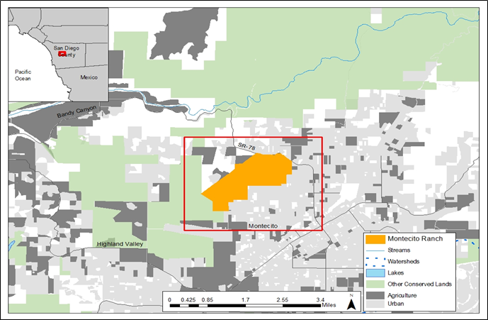
A Framework Resource Management Plan (F-RMP) for the Montecito Ranch Preserve was developed jointly by Jessie Vinje, CBI, Michael White, Endangered Habitats Conservancy (EHC), Steve Montgomery, ECORP Consulting, Inc., and the San Diego Management and Monitoring Program (SDMMP) in coordination with the United States Fish and Wildlife Service (USFWS), California Department of Fish and Wildlife (CDFW), and the U.S. Department of Defense. The F-RMP aligns preserve-level management and monitoring with the regional Management and Monitoring Strategic Plan (MSP Roadmap) for conserved lands in western San Diego County (SDMMP and TNC 2017). The MSP Roadmap provides regional and preserve-level goals and objectives for prioritized species, vegetation communities, and threats, and includes recommendations from regional planning documents. Together with its partners, CBI developed the F-RMP over 2.5-years by compiling and reviewing existing documents, literature, and spatial datasets, conducting rapid assessment surveys for biological resources, and meeting with species and regional experts.
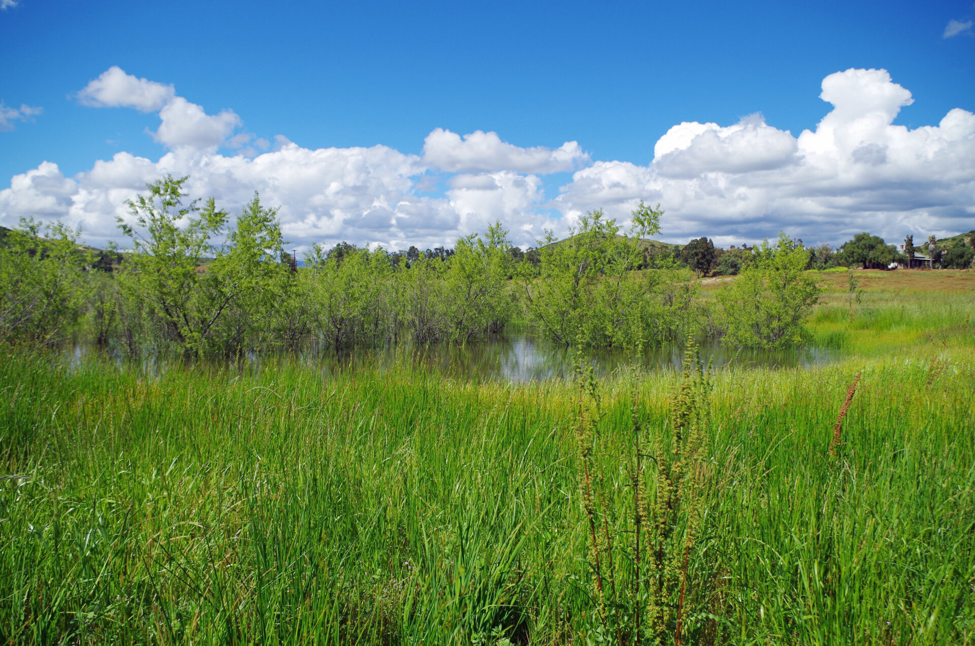
The Preserve is a 955-acre perpetually conserved property located in west-central San Diego County near the town of Ramona. The Preserve is contiguous with the County of San Diego’s Ramona Grasslands County Preserve (Ramona Grasslands) and is located within the original Rancho Valle de Pamo (also called Rancho Santa Maria) Spanish land grant and on historical Kumeyaay land.
Montecito Ranch lies within the North County Multiple Species Conservation Plan (NCMSCP), a draft NCCP area, but was originally slated for development. EHC acquired the 955-acre ranch on June 10,2020, with funding from Section 6 of the Federal Endangered Species Act (ESA) of 1973, as amended. Specifically, two habitat conservation plan land acquisition grants associated with the County of San Diego Multiple Species Conservation Program (MSCP) were awarded funding for the acquisition of land that complements the MSCP and benefits covered listed and unlisted species. The California Wildlife Conservation Board (WCB) provided funding including the requisite non-federal matching funds for Section 6 grants and the U.S. Department of Defense provided 50% of the acquisition cost through its Readiness and Environmental Protection Integration (REPI) program, leveraged additional acquisition funding.
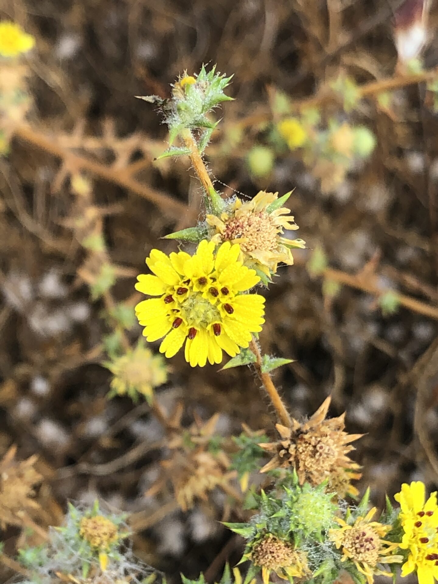
Montecito Ranch supports the federally threatened coastal California gnatcatcher (Polioptila californica californica), federally endangered San Diego fairy shrimp (Branchinecta sandiegoensis) and federally endangered Stephens’ kangaroo rat (Dipodomys stephensi) in addition to providing foraging and wintering habitat for raptors including golden eagle (Aquila chrysaetos canadensis) and other birds, and habitat for reptiles, amphibians, and mammals including American badger (Taxidea taxus). The Preserve supports vernal pools including the rare southern tarplant (Centromadia parryi subsp. australis), oak woodlands including the rare Engelmann oak (Quercus engelmannii), grasslands, coastal sage scrub, and chaparral habitats.
The Wildfire Resilience Planner: Strategic Planning at the Landscape Scale
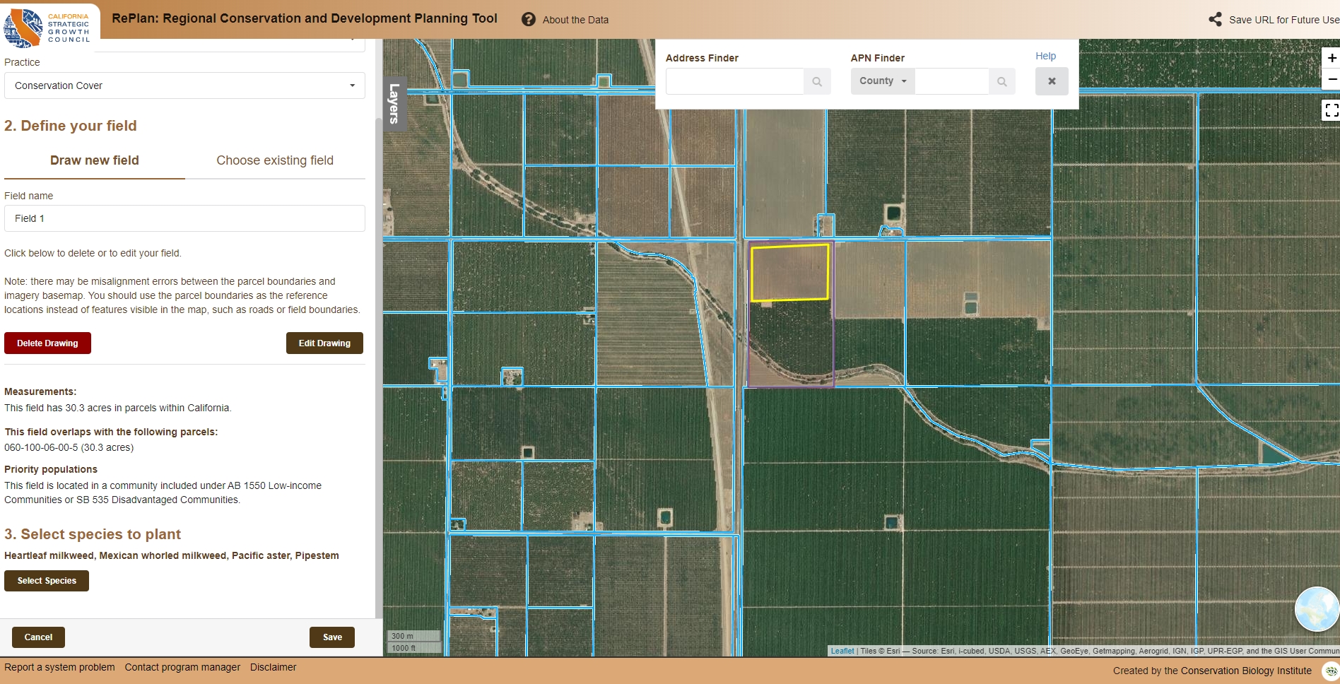
Sonoma Water, Conservation Biology Institute (CBI), Ag Innovations, Pepperwood Preserve, Tukman Geospatial, Digital Mapping Solutions have created the Sonoma County Wildfire Resilience Planner, an online decision support tool for prioritizing locations to reduce wildfire fuels to protect lives and property, community infrastructure, ecosystem services, and biodiversity. The tool encourages collaborative planning of projects on public and private land, helping to leverage individual efforts for a unified and strategic approach to fuels management. The Wildfire Resilience Planner is available for use at https://sonoma.resilienceplanner.org/. For more information or to provide feedback, please contact Molly Oshun, Molly.Oshun@scwa.ca.gov or Deanne DiPietro, deanne.dipietro@consbio.org.
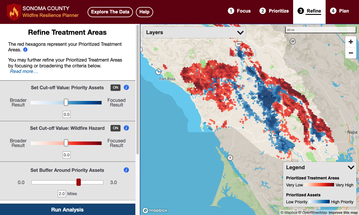
Above: the Sonoma County Wildfire Resilience Planner provides the user with the spatial data and analysis tools to identify high-priority locations for wildland fuels management.
The USFS Forest Inventory and Analysis (FIA) team, regional partners and CBI developed the Micronesia Challenge Regional Terrestrial Monitoring Initiative tool (mcterrestrialmeasures.org) to allow users to visualize the spatial data from the Micronesia Challenge monitoring effort by regional framework indicator(s) that measure the status of managed conservation areas set aside under the program. Forest data were collected between 2003 and 2018 and are now being used to determine the status and trends in forest area, forest health, understory vegetation, biomass, and carbon storage.
The Micronesia Challenge is a commitment by the Republic of Palau, Guam, the Commonwealth of the Northern Mariana Islands, the Federated State of Micronesia, and the Republic of the Marshall Islands to preserve the marine and terrestrial resources that are crucial to the survival of the Pacific traditions, cultures and livelihoods. The overall goal of the Micronesia Challenge is to effectively conserve at least 30% of the near-shore marine resources and 20% of the terrestrial resources across Micronesia by 2020.
The Healthy Soils Program (HSP), which is managed by the California Department of Food and Agriculture (DFA), provides financial support to California growers and ranchers to implement conservation management practices on their land that help sequester carbon, reduce atmospheric greenhouse gases, and improve overall soil health. CBI’s web tool was developed to assist Healthy Soils Program applicants to submit funding proposals and help agency staff make awards more efficiently.
The California Department of Food and Agriculture (CDFA) Alternative Manure Management Program (AMMP) provides financial incentives for the implementation of non-digester manure management practices on dairy and livestock operations in California, which will result in reduced greenhouse gas (GHG) emissions. This web application primarily provides tools for potential applicants to map out their project site’s current practices and proposed alternative manure management practices which are supported by AMMP. The tool also assesses the proposed project’s estimated GHG reductions (following the AMMP Quantification Methodology and accompanying Benefits Calculator Tool developed by the California Air Resources Board).
The CDFA AMMP Project Planning Tool provides California dairy and livestock operators an opportunity to easily visualize an alternative manure management practice that reduces carbon emissions, using simple ways of mapping proposed operations on the farm. The Tool increases access for potential applicants to create maps describing their current and proposed manure management, thus improving their AMMP grant applications, and our ability to review projects efficiently. The CBI team did an amazing job communicating with us regularly, offering suggestions, and helping put our ideas and the rather complex elements of our grant program together into a really beautiful and user-friendly tool.
Alyssa Louie – Senior Environmental Scientist, California Department of Food and Agriculture