The California Department of Food and Agriculture (CDFA) Alternative Manure Management Program (AMMP) provides financial incentives for the implementation of non-digester manure management practices on dairy and livestock operations in California, which will result in reduced greenhouse gas (GHG) emissions. This web application primarily provides tools for potential applicants to map out their project site’s current practices and proposed alternative manure management practices which are supported by AMMP. The tool also assesses the proposed project’s estimated GHG reductions (following the AMMP Quantification Methodology and accompanying Benefits Calculator Tool developed by the California Air Resources Board).
The CDFA AMMP Project Planning Tool provides California dairy and livestock operators an opportunity to easily visualize an alternative manure management practice that reduces carbon emissions, using simple ways of mapping proposed operations on the farm. The Tool increases access for potential applicants to create maps describing their current and proposed manure management, thus improving their AMMP grant applications, and our ability to review projects efficiently. The CBI team did an amazing job communicating with us regularly, offering suggestions, and helping put our ideas and the rather complex elements of our grant program together into a really beautiful and user-friendly tool.
Alyssa Louie – Senior Environmental Scientist, California Department of Food and Agriculture
RePlan is a core component of the California Strategic Growth Council’s (SGC) Integrated Regional Conservation and Development (IRCAD) initiative. This online tool supports the development and implementation of a sustainable and balanced vision for regional conservation and economic development. RePlan integrates the latest environmental, social, and economic data with analytic and reporting tools to allow users to identify optimal locations for implementing California’s conservation, resource management and development objectives. This tool helps to align regional planning and management activities in light of State and regional conservation, development, equity and resilience goals.
It was built to to assist with planning energy development throughout the state. The CEIPA helps improve planning efficiency and avoid environmental risks based on the best available terrestrial and offshore datasets. This is an easy-to-use application allowing users to filter and locate areas that meet specified criteria of interest.
The Marsh Adaptation Planning Tool (MAPT) supports the The Regional Strategy 2018 of the Southern California Wetlands Recovery Project. This new mapping tool – developed by CBI – illustrates and quantifies the ecological state and future potential of wetland zones. The WRP and its partners will use the MAPT to develop, evaluate, and prioritize restoration projects.
The Columbia Plateau in eastern Washington supports productive farmland and rangeland as well as native shrub-steppe habitat of which only 40% remains intact. The region also contains some of the most sought after land in the state for utility scale solar energy development, which is an important component of its future energy portfolio that strives to produce 80% of the state’s electricity from renewable sources by 2030 and 100% carbon-free by 2040.
CBI has been chosen by the Washington State University Energy Program to provide the science and mapping component in support of a voluntary, collaborative effort that brings stakeholders together in order to identify areas of least-conflict between solar energy development and other important ecological, economic, and social values in order to meet the state’s carbon-free energy goals. CBI’s contribution to this process is based on the successful pilot to this approach in the San Joaquin Valley in California. The project will include a new Data Basin gateway, which is a customized site for accessing the science and mapping resources for this project.
See the recent brochure published by Washington State University for more information.
This report evaluates the impact that administrative and ecological constraints might have on the amount of forest biomass that could be extracted for energy use in the Southeastern U.S. Using available spatial datasets, we quantified and mapped how the application of various “conservation value screens” would change previous estimates of available standing forest biomass (Blackard et al. 2008). These value screens included protected areas managed for conservation values, USDA Forest Service and Bureau of Land Management (BLM) lands, steep slopes, designated critical habitat for federally-listed threatened and endangered species, inventoried roadless areas, old-growth forests, wetlands, hydrographic (lake, stream, and coastline) buffers, and locations of threatened and endangered species (G1-G3, S1-S3).
Two alternative combinations of values were examined: in Alternative 1, all areas within value screens, including all Forest Service and BLM lands, were excluded from biomass development. In Alternative 2, Forest Service and BLM lands not afforded extra protection by such designations as wilderness or research natural areas were assumed available for biomass extraction; all other values continued to be excluded from extraction. In both alternatives, biomass located within the Wildland-Urban Interface (WUI) was assumed available for extraction regardless of conservation value screens.
The analysis was conducted at 100-m x 100-m resolution. Summary statistics were derived at three scales – entire study area, 13 states, and 24 World Wildlife Fund (WWF) ecoregions. Results were also summarized and mapped for all 1,342 counties.
Finally, we compared hydrologic datasets at two different scales (1:24,000 and 1:100,000) at multiple sample areas in the study area to evaluate how hydrologic scale might affect the delineation of riparian reserves and resulting estimates of biomass availability.
CBI developed and applied a forest management decision-support system (DSS) for forest resilience planning in the southern Sierra Nevada that integrates the latest science on how vegetation, terrain, climate, and weather interact to influence fire risks and forest resilience. The interdisciplinary team led by CBI includes ecological modelers, forest ecologists, fire scientists, physicists, and statisticians. The core of the DSS will be a Forest Resilience Model built using EEMS (Ecosystem Evaluation Modeling System; Sheehan and Gough 2016). The DSS was tested, refined, and applied to resilience planning in that portion of the modeling region of greatest concern to the interagency Sequoia Regional Partnership, which is working to restore ecologically resilient conditions in and near Sequoia National Forest and Sequoia-Kings Canyon National Park.
This project addressed the need for regionally-relevant forest management decision support tools by developing new models and maps of severe wildfire risk and drought-related tree mortality in the southern Sierra Nevada. The models include multivariate statistical models of drought and fire risks, and transparent modular models using the fuzzy-logic modeling system, EEMS (Ecosystem Evaluation Modeling System (Sheehan and Gough 2016)). The statistical models used the best variables and data available at the time of the project to provide recent snapshots of forest conditions and were used to inform development of the updateable EEMS models to be used in decision-making. The EEMS models of forest resilience rely on variables and datasets that can be updated to reflect environmental change.
This project also developed a method of using statewide forest structure data from the California Forest Observatory (CFO) (California Forest Observatory 2020)) to calculate vegetation-created wind-drag at 10m horizontal and 1m vertical resolution based on how trees, shrubs, and ground cover affect winds below, within, and above forest canopies. These vegetation-based wind-drag coefficients can be used to calculate how oxygen flow to fires is affected by forest structure and thus affects fire behavior. Changes in forest structure, for example due to fires or fuels treatments, may affect fire behavior and the likelihood of extreme wildfire behavior induced by atmosphere-fire coupling (Coen et al. 2020). Because CFO data are California-wide and were expected to be annually updated, wind-drag maps could be updated annually and used to guide fuel-treatment priorities. These results can be immediately applied to improving assessment of the effects and effectiveness of fuels treatments using operational fire models, which to date have not accounted for how reducing fuels also increases ventilation (e.g., FlamMap 6.2). Although the scientific consensus has been that fuels treatments reduce fire intensity within the treatment footprint, it is essential to understand and quantify how they may also increase ventilation into neighboring areas, and hence potentially increase fire risks in unintended ways.
The DSS will be further refined and applied to resilience planning by the Sequoia Regional Partnership, whose primary focus is reducing fire risks to giant sequoia groves, fishers, and human communities.
External Team members include: Joe Werne (NorthWest Research Associates NWRA), Christopher Wikle (Department of Statistics, University of Missouri) and David Marvin (SALO Science).
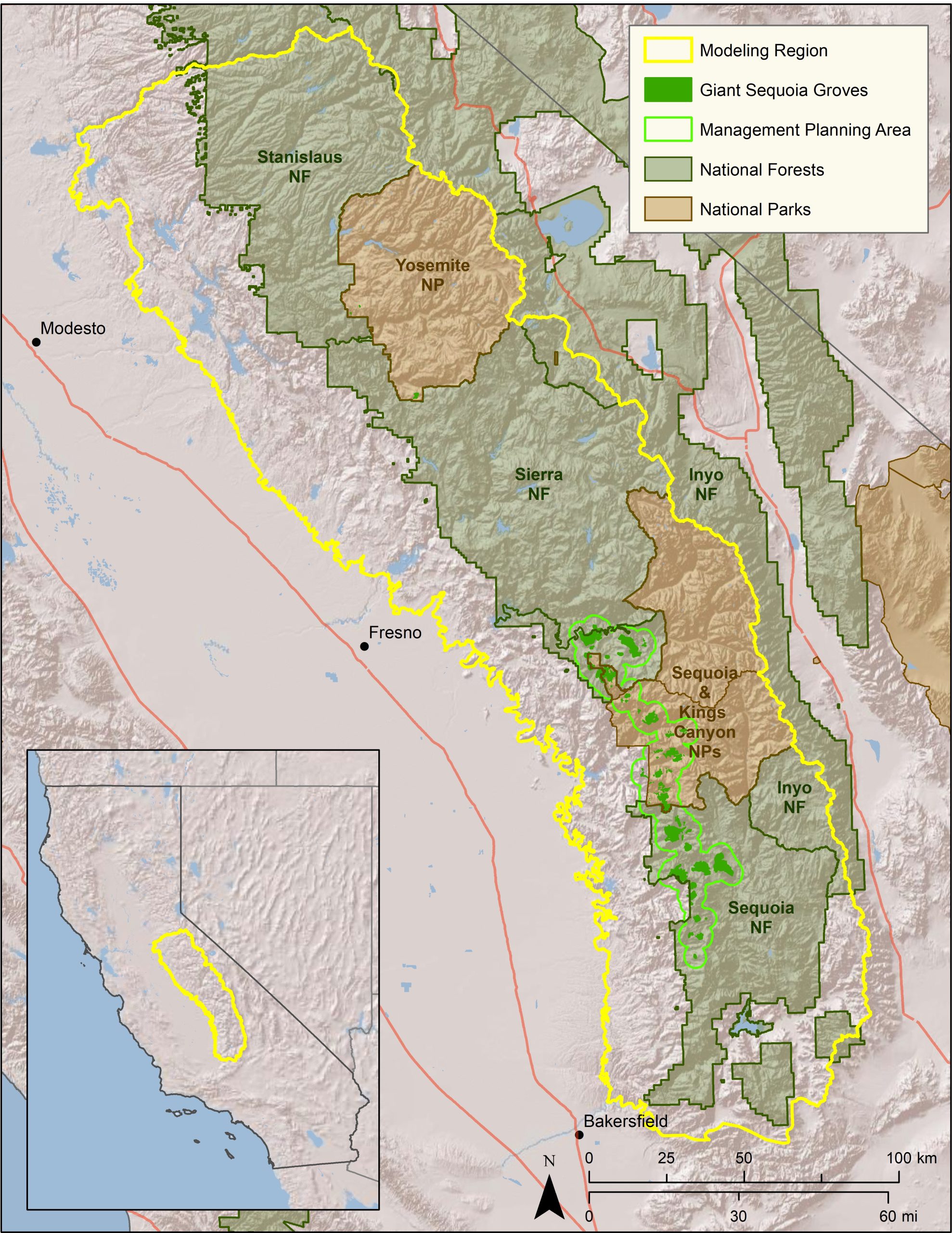 Map of project study area.
The Forest Treatment Planner was developed to provide forest managers a platform for exploring the potential consequences of different forest management alternatives in both the short and long-term, examine the resource-based trade-offs inherent in any proposed vegetation management action, and clearly substantiate the rationale behind management planning. Originally envisioned as a means to help balance fisher habitat conservation with fuel reduction efforts, the Treatment Planner provides a dynamic link between GIS, the Forest Vegetation Simulator (FVS) modeling software, and any resource model (e.g. habitat, hydrology, fuel, economic) that uses the EEMS (Environmental Evaluation Modeling System) modeling environment. As such, the Treatment Planner is not a model per-se, but a system of communication between existing software that, when used together, can facilitate spatially-explicit comparisons and project refinement. By exporting an FVS output directly into the EEMS modeling environment, this framework allows for a transparent evaluation of the impacts to multiple resource values and a straightforward process for communicating these impacts to stakeholders.
The Treatment Planner supports an iterative process of treatment project simulation, adaptive management, and outcomes analysis, the steps in what we refer to as the “4-Box” decision making framework. The 4-Box model is a conceptual representation of a process designed to help predict future landscape conditions based on simulated management actions and change over time (see Figure). In this process, the forest manager first examines the current conditions of the landscape through the lens of a particular question or management objective (e.g., where is there a need for protection or restoration?). They can then explore the predicted effects of various simulated management alternatives (e.g., thin from above, or thin from below), to see how they would affect the stand structure (e.g., stand density, basal area, and average DBH) over time, both immediately and into the future. Finally, the manager can examine how those new conditions would then affect a particular phenomenon of interest such as, severe fire risk, or wildlife habitat suitability. This process is then repeated under a different set of treatment options (scenarios) to inform the development of an effective management strategy.
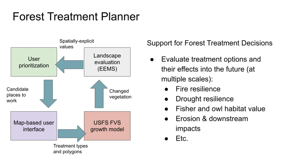
Figure 1. The 4-Box model represents a process for evaluating future conditions based on simulated treatments and change over time.
You can check out the detailed steps to use the treatment planner using the document on the file tab. The relevant code for the treatment planner is available at github, click here to download.
Algerian sea lavender (Limonium ramosissimum) and European sea lavender (Limonium duriusculum) are invasive, nonnative perennial plants known to invade salt marsh and upland transitional habitats in coastal California in addition to disturbed inland habitats. While striking in appearance, these two species cause angst among coastal land managers and biologists when detected in salt marsh habitat in San Diego, California. These two species are difficult to eradicate and capable of invading and densely occupying tidal marsh habitat. If left unmanaged these species can displace native vegetation causing loss of breeding and foraging habitat for the endangered Belding’s savannah sparrow (Passerculus sandwichensis beldingi) and extirpating local populations of the endangered salt marsh bird’s beak (Chloropyron maritimum ssp. maritimum).
In 2021, CBI received funding from the United States Fish and Wildlife Service Coastal Program and the San Diego National Wildlife Refuge Complex to determine the distribution of Algerian and European sea lavender and initiate a control program to eliminate these species from San Diego Bay to prevent degradation of salt marsh habitat and potential loss of endangered animal and plant populations. Project partners include the California Department of Parks and Recreation, Port of San Diego, United States Department of the Navy, and the San Diego Bay National Wildlife Refuges.
In August, 2025 CBI was awarded a multi-year award (2025-2028) by the California Wildlife Conservation Board to survey, map, and enhance coastal habitat by controlling these two nonnative species in San Diego Bay in close partnership with multiple agencies and organizations. The management goal is to reduce the distribution of Limonium spp. by 99 percent across approximately 118 acres of mid- to high elevation sale marsh, salt marsh-upland ecotones, and adjacent upland and riparian habitat to benefit 15 rare plants and animals native to the San Diego Bay region.
Conservation Biology Institute is supporting the Spatial Informatics Group – Natural Assets Laboratory (SIG-NAL) on a multi-year Regional Wildlife Mitigation Program (RWMP) in Santa Barbara county that is funded by the National Fish and Wildlife Foundation. Specifically, CBI in partnership with SIG-NAL will develop and propose a fire-resistant buffer or “greenbelt” area in strategic locations within the program area to create wildfire resilient green space, working lands, and habitats. Program outcomes will also provide numerous co-benefits that support watershed and coastal ecological health using a suite of tools including:
- Live oak shaded fuel breaks
- Habitat restoration
- Prescribed herbivory
- Hydrated and agricultural buffers
- Land Conservation
The RWMP is designed to assess hazard, exposure and vulnerability and equitably reduce wildfire hazard across the Santa Barbara front country. The program goals are to decrease the risk of wildfire impacts to structures and infrastructure, promote wildfire resilient green space, working lands, and habitats, and develop community capacity to adapt and recover from the shocks of natural disasters. The Program is divided into three primary Resilience Domains: the Landscape Resilience Domain, the Built Environment Resilience Domain, and the Community Resilient Domain. Each domain will work collaboratively to foster resilience and build adaptive capacity that will allow the community to prepare, respond and recover from the shock of large wildfires. More details can be found at this link: https://rwmpsantabarbara.org/.