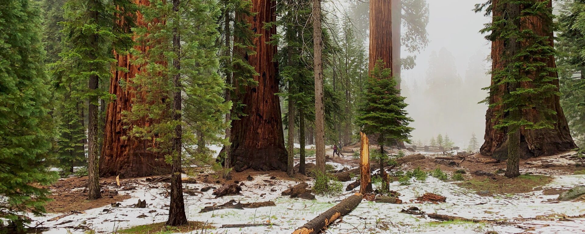
The need to plan strategic, effective forest management is urgent in the southern Sierra Nevada, where forests have been ravaged by drought, fire, and catastrophic tree mortality. Multiple, sometimes conflicting, management objectives must be balanced, and multiple agencies need help coordinating their forest restoration actions. A common, readily accessible system evaluating landscape-scale forest condition is needed.
Conservation Biology Institute is working with the Sierra Nevada Conservancy, Sequoia National Forest, Sequoia National Parks, Sequoia Parks Conservancy, Save the Redwoods League, and others to develop forest resilience models and create a toolkit for exploring these data to support the planning of a range of resource management goals. These goals include the protection of sequoia groves, overall forest health, wildfire protection, and endangered species habitat management. The project is supported by CBI’s data sharing and mapping platform Data Basin. The project is funded by the Save the Redwood League and Sequoia National Park through its partner the Sequoia Parks Conservancy, and CAL FIRE Forest Health Research Grant Program.
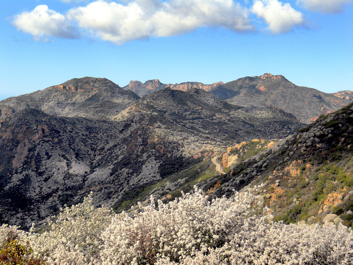
Conservation Biology Institute and the Resource Conservation District of the Santa Monica Mountains are working in partnership with local land management agencies and communities to increase wildfire resilience in the Santa Monica Mountains region. The Program has the following tasks:
Raising awareness about wildfire risk in the local communities
- Providing Home Ignition Zone Evaluations to help homeowners reduce their fire risk. If you are interested in having your home evaluated, or getting trained to do evaluations in your neighborhood, contact the RCD SMM.
- Surveying residents about their knowledge of wildfire risk and what they can do to reduce it. Here are the results of the 2021 Survey, and you can take the 2022 Santa Monica Mountains Wildfire Preparedness Survey here.
Helping homeowners prepare for wildfire
- The program provides assistance to homeowners to reduce their wildfire susceptibility by removing hazard trees and restoring burned landscapes to buffer neighborhoods from wildfire
- Learn more about home hardening and ecologically-appropriate defensible space techniques at http://defensiblespace.org.
Mapping and planning the control of flammable invasive weeds in the Woolsey Fire footprint
- The program and its partners Santa Monica Mountains National Recreation Area, Santa Monica Mountains Conservancy, and California State Parks have contracted with Wildlands Conservation Science to conduct aerial surveys to map invasive plant species in the public lands of the Santa Monica Mountains to inform land management to increase future public safety and wildfire preparedness.
- The data and a comprehensive weed control plan will be available by the end of 2023.
Modeling and research to inform planning and decision making
- Program partner U.S. Forest Service Missoula Fire Sciences Lab is modeling ember transport at the property scale under different defensible space conditions. Results of this study will be available in early 2023.
- Conservation Biology Institute conducted ignition and large fire probability modeling to help prioritize locations for risk reduction. See these results here: Wildfire Ignition Potential and Large Wildfire Potential models. You may also see this Wildfire Model Comparison for SMM Region to compare and get access to other important fire risk and hazard maps.
The Santa Monica Mountains Woolsey Fire Recovery and Adaptation Program is funded by the National Fish and Wildlife Foundation.
CBI worked closely with the Department of Land Conservation Development (DLCD) and other project collaborators to carry out an expansive spatial data review and stakeholder engagement process to better understand renewable energy opportunities and constraints in Oregon. It was part of a larger effort called the Oregon Renewable Energy Siting Assessment (ORESA) project, which was funded by the U.S. Department of Defense Office of Economic Adjustment. This larger project included Oregon Department of Energy (ODOE) working closely with Oregon Department of Land Conservation and Development (DLCD) and Oregon State University’s Institute for Natural Resources (INR).
Data Basin was used to support the spatial data review process resulting in a transparent and accurate spatial data library needed for effective renewable energy planning in the state. Approximately 650 datasets were reviewed with most of them still available on Data Basin. The final Opportunities and Constraints final report was included as part of supporting materials to the larger project.
Conservation Biology Institute is a partner in a new $1 million grant from a new interdisciplinary NSF program to foster building an “open knowledge network.” The inspiration for this type of network comes from Tim Berners-Lee’s (best known founder of the World-wide Web) vision for the “semantic web,” which applies tags with relationships to information on the Internet, allowing computers to do basic reasoning for improving search results and answering questions. Apple’s Siri, Amazon’s Alexa, and Google’s Assistant all use these technologies.
Dr. John Gallo co-wrote the proposal and leads CBI’s participation in the team of 13 researchers and practitioners from 10 other institutions. The team is focused on improving access and contributions to tools for analyzing geographic data called spatial decision support systems. “The proliferation of online mapping technologies has greatly increased access to and utility of these kinds of tools, and a logical next step is increasing our ability to find the appropriate data and tools for your problem and link these together for more complex analyses,” says Principal Investigator Sean Gordon of Portland State University. Through engaging stakeholders in three applied case studies (the management of wildland fire, water quality, and biodiversity conservation), the interdisciplinary project team will develop and test participatory and automated methods for finding and sharing decision-relevant information using semantic web technologies.
The new NSF Convergence Accelerator program is named for its focus on bringing together interdisciplinary teams to address one of NSF’s 10 big ideas, specifically “Harnessing the Data Revolution“, also known as building an Open Knowledge Network. Eighteen other of these phase 1 grants were made, covering areas from molecular manufacturing to tracking potentially disruptive solar phenomena. The “accelerator” part comes from the short time frame. “The application required a 3-week turn around, which is very quick for a NSF grant,” Gordon said. “Our success was largely due to having formed the Spatial Decision Support Consortium, a professional networking group four years ago, so we had ideas and people ready to go.” Each phase 1 project is eligible to submit a phase 2 proposal for up to $5 million by next March, and the process will include giving a short “pitch” talk to a panel of experts and potential funders, much like a venture capital approach.
*Learn more about this ongoing project here.
The USDA Conservation Reserve Program (CRP) works with farmers and landowners to implement conservation management practices on enrolled lands, with paid contracts ranging from 10 to 15 years in length. The CRP Grasslands practices target restoration of agricultural grassland systems by augmenting native vegetation for pollinators, providing habitat for grassland plants and animals, increasing biodiversity, reducing soil erosion, and improving water quality. The USDA’s CRP has been successful in improving the conservation value of millions of acres of farmlands; however, the program currently lacks spatially explicit information on land cover and vegetation within CRP-enrolled tracts.
In partnership with the USDA FSA program, the Conservation Biology Institute (CBI) used a combination of remote sensing and machine learning algorithms deployed on the innovative cloud-computing platform, Google Earth Engine, to map grassland characteristics. We used a rich suite of enviro-climatic data, multiple sources of satellite imagery, and Random Forest modeling techniques to predict land cover for study areas in Washington, Colorado, and Kansas, where CRP Grasslands holdings are most prevalent. We used machine learning to create predictive maps of vegetation type by leveraging an extensive set of satellite-derived variables, environmental layers, and federal survey data (from BLM’s AIM and USDA NRCS’s NRI programs). Our initial investigation utilized Landsat 8 satellite data to model vegetation cover across the Washington study area and then scaled up to the Colorado-Kansas study area. The Washington study site was selected for further model enhancements and an in-depth comparison of Landsat 8, Sentinel-2, and MODIS satellite imagery, to evaluate differences in model development and performance among sensor types. We generated vegetation cover predictions for the year 2019 using Random Forest classification models. Classified outputs for the five vegetation cover models – annual grass, perennial grass, annual forb, perennial forb, and bare soil – were post-processed to exclude water and urban land cover and areas that were not relevant for mapping grasslands.
Mapped outputs showing vegetation percent cover predictions from our pilot project have been integrated into CBI’s CRP online decision support tool. This online tool offers functionality for managers and landowners to view, filter, compare and summarize geospatial information relevant for assessing CRP tracts in the study areas. You will need permission from USDA to use the tool, but it is available at https://crptool.org/. Anyone can view the design of the tool at USDA CRPtool.
You can read more details in the following publication.
Degagne, Rebecca; Pizzino, Declan; Friedrich, Hannah; Gough, Mike; Joseph, Gladwin; Strittholt, James; et al. (2022): Mapping Conservation Reserve Program Grasslands in Washington, Colorado, and Kansas with Remote Sensing and Machine Learning. figshare. Journal contribution. https://doi.org/10.6084/m9.figshare.19141853.v1
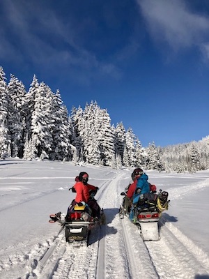
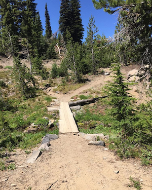
The Conservation Biology Institute and the Deschutes Trails Coalition (DTC) are in the process of developing a web-based system to assist the DTC in sustainably managing multi-use trails in Deschutes County. The collaborative process of creating a framework to support DTC’s decision making relies on modeling Environmental, Economic, Physical, and Social Sustainability of recreation activities and trails.
*Images provided by Danielle MacBain at the Deschutes Trails Coalition.
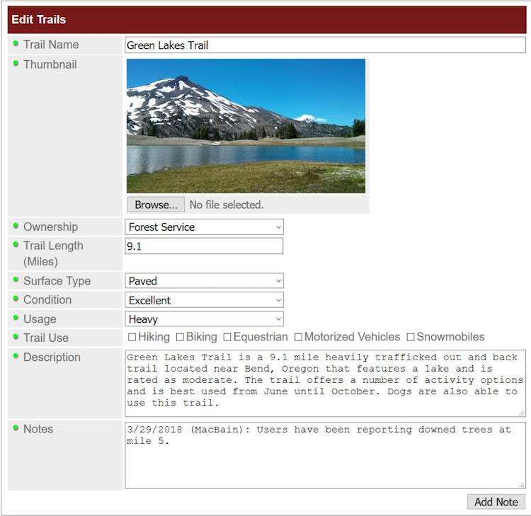
*The DTC Dashboard will include a form-based system to give users the ability to enter or modify information in the trails database.
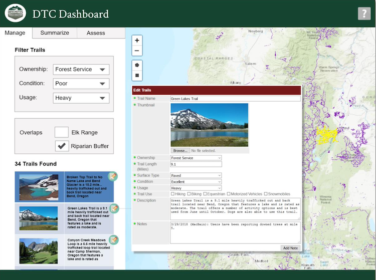
*Mockup of the DTC Dashboard (Query Tools on the Manage Tab)
Conservation Biology Institute specializes in harnessing the power of spatial data for conservation planning and decision-making. We create tools in close collaboration with state agencies that help them achieve their missions. Recently we’ve had the opportunity to work with the California Department of Food and Agriculture (CDFA).
The CDFA Healthy Soils Program promotes the development of healthy soils on California’s farmlands and ranch lands by providing financial incentives to California growers and ranchers to implement agricultural management practices that sequester carbon, reduce atmospheric GHGs and improve soil health.
Conservation Biology Institute created the CDFA Healthy Soils Program tool, an online tool to streamline the submission process for proposals to the Healthy Soils Program. This tool, a custom module of RePlan, allows a grant recipient to locate and map proposed conservation practices, view and select from recommended species for planting, and conform with multiple project eligibility requirements. All project components are then summarized in a proposal report for upload to the CDFA Healthy Soils Program project submission website.
*Find the tool here: https://sitecheck.opr.ca.gov/
Conservation Biology Institute is working in partnership with Riverside County Habitat Conservation Agency, Bureau of Land Management, U.S. Fish and Wildlife Service, San Diego Zoo Wildlife Alliance Academy, and others to develop and implement a rangewide conservation plan for the Stephens’ kangaroo rat (Dipodomys stephensi, SKR), a tiny rodent native to Southern California’s shrinking grassland habitats.
The SKR Rangewide Management and Monitoring Plan, developed in collaboration with species managers, researchers, and land owners, complements existing management plans rather than replaces them, recognizing that each location has unique management priorities. Coordinating across local conservation efforts will facilitate collaborative conservation action across the species’ entire range.
The SKR Plan recommends management actions to improve habitat and ameliorate threats from human activities and climate change and provides a standardized monitoring protocol to track the species’ population status and trends. CBI has developed a customized field data collection application using ArcGIS Field Maps, and our SKR data management team supports the field monitoring effort and ensures long-term integrity of the data in partnership with USFWS’ Ecosphere Program.
This work builds upon a habitat suitability model developed in 2019 by Conservation Biology Institute using Sentinel-2 satellite imagery and being updated in time to support the 2024 monitoring season. These updatable landscape-scale habitat maps are the foundation for statistically-defensible monitoring and play a key role in planning coordinated conservation of the species.
This work is funded by the U.S. Bureau of Land Management. For more information about this effort, please contact Wayne Spencer at wdspencer@consbio.org or Brian Shomo at bshomo@wrcog.us.
Please see the SKR Rangewide Management and Monitoring Website for The SKR Rangewide Management and Monitoring Plan and Protocol, as well as other documents, maps, and data from this project.
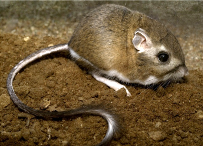
Stephens’ kangaroo rat (Dipodomys stephensi, SKR). Photo by Moose Peterson.
In this project, CBI is a member of and also providing support to the Fort Bragg Headlands Consortium, with a mission to to help achieve environmentally sound restoration and development solutions that will improve the quality of life and economy for current and future residents of our Coast.
CBI’s major contribution to the Consortium is to develop and maintain the Fort Bragg Headlands web-mapping Gallery. Powered by Data Basin, this web-mapping Gallery is a feature-rich platform for local citizens, stakeholders and decision-makers to access publicly available spatial data (e.g. maps of streams, wetlands, hazards, soils, geology, etc.). This is timely, as Fort Bragg is currently making a significant Local Coastal Program (LCP) Amendment. Currently zoned Forest Light Industrial, these zoning changes will make the third of the city that was once a lumber mill into prime real estate zoned for profitable development. Fort Bragg is also figuring out how to deal with the remaining wetlands out there that still contain hazardous materials despite a first round of clean-up by the landowner. Providing easy access to data and maps will facilitate decisions that conserve the landscapes and biodiversity of the Fort Bragg region while bringing much needed development and jobs to sustain current and future generations. You can donate directly to this cause here.
Wildfires are a natural part of California ecosystems and play an important role in maintaining ecological structure and function. However, different fire regimes in the state have been altered due to past management practices, climate change, invasive species, and population growth and urban expansion. Given the potential for conflicts between fire management and conserving biodiversity and ecological functioning, solutions are needed to balance ecosystem health with human welfare and community safety.
CBI is partnering with Dr. Jon Keeley (USGS) and an international team of landscape ecologists, biologists, geographers and economists to study the factors that control wildfire activity in southern California, which experiences the largest number of housing losses to wildfire in the U.S. This work focuses on the role of different ignition sources, climate patterns, vegetation change, and housing location and arrangement in altering fire patterns and contributing to housing loss at the wildland-urban interface. Other topics of research include the effectiveness and effects of fuel treatments and prescribed fire in controlling large fire behavior; the role of homeowner practices, such as minimizing vegetation around homes and upgrading building construction materials to prevent house loss; and the relative importance of land planning decisions that could best minimize housing loss while preventing negative impacts to biodiversity.
While the research takes place primarily in southern California, the findings are applicable to other fire-prone non-forested ecosystems such as the Great Basin and the other Mediterranean-climate ecosystems across the world.
The results of this research are shared with management agencies like the National Park Service and U.S. Forest Service, in addition to local and state planners and policy makers, to identify the best strategies to increase community safety while minimizing effects on natural ecosystems.
nflicts between fire management and biodiversity conservation