
1. Protected areas form one of the main pillars of biodiversity conservation throughout the world. Only 1.2 percent of the Alberta Foothills is currently protected, which is woefully inadequate by any scientific standard.
2. Protecting the full array of native biodiversity (representation) is an extremely important consideration in a regional protected areas strategy.
3. Approximately 75 percent of the natural variability present in the Alberta Foothills (measured as enduring features) is not adequately represented in a network of protected areas.
4. Approximately 82 percent of the region is comprised of logging tenures and much of this same area is subjected to intensive oil and gas development.
5. Change detection analysis has shown that nearly 9 percent of the ecoregion (~640,000 ha) has been impacted by activities visible from space since 1990 and much of this has been either by a growing network of oil and gas infrastructure or as clusters of clearcut logging. Impact on some species (e.g., woodland caribou) far exceeds this area.
6. The region contains over 36,000 wells, numerous pipelines, and thousands of kilometers of seismic exploration.
7. The Alberta Foothills no longer possesses large intact forest landscapes (undisturbed blocks >50,000 ha), but approximately 1/3 of the region is comprised of smaller forest remnants (over 2,100 with mean size of 1,500 ha) which forms the natural backbone of the region and form one of the major building blocks for protecting the many ecological values identified in the region.
8. Biodiversity values evaluated in the endangered forest mapping included: (1) rare forest types (old growth and less fragmented forests), (2) locations of rare and endangered species and their special habitats, (3) woodland caribou, (4) grizzly bear, (5) freshwater species such as bull trout and arctic grayling, and (6) forest and water-dependent bird species. Many of these values are being seriously degraded and some threatened with local extinction.
9. Decision support mapping results highlight areas within the Alberta Foothills that still contain high values and some of these values are of global or national significance. The highest scoring areas should be considered as candidates for an expanded protected areas network for the region. Recommended starting target should be approximately 16 percent of the ecoregion including existing and new protected areas. Failure to act will result in numerous species extirpations and significant loss of overall ecological integrity, including the degradation of several important ecosystem services.
10. In addition to new protected areas, landscape connectivity along waterways and over land should remain as an important consideration in an overall regional conservation strategy.
11. To be effective, an expanded protected area network alone will not be enough to maintain the conservation values present in the region today. New protected areas should be established strategically in the context of a region under dramatic pressure from development and extractive use. Management and even restoration in some areas should also be considered in an overall plan to achieve ecological sustainability.
12. The combination of Neatweaver®, EMDS®, and ArcMap® provides a powerful decision support planning tool set that can successfully address the topic of High Conservation Value and Endangered Forests.
In November 2002, two science-based conservation organizations, the Conservation Biology Institute (Corvallis, Oregon) and World Wildlife Fund (Ashland, Oregon), conducted an ecological assessment of the mid and lower reaches of the Klamath, including its tributaries and the Upper Sacramento River that flows into the mid Klamath.
Ecosystem health was assessed using computer mapping (Geographic Information Systems – GIS) and satellite interpretation technologies across 870 watersheds; 655 within the mid and lower Klamath and 215 within the Upper Sacramento River. We used a series of indicators or surrogates to assess watershed condition on a relative basis, including road density, stream-road intersections, logging in the basin over a three-decade period, and mining activities.
Because this is the first subbasin assessment of relative ecological condition of the mid and lower Klamath River, this executive summary will focus mainly on the Klamath findings as they are particularly relevant to policy and legislative efforts to manage water uses and restore ecosystem health throughout the Klamath River. In addition, according to monitoring stations of the United States Geological Service, the Klamath is in worse shape today than it was in 2002, the year that 34,000 to 68,000 salmon and trout died from disease in the lower Klamath River due primarily to low water flows and high water temperatures.
As more people move into remote areas throughout western forests and rangelands, it is increasingly important for scientists, land managers, policy makers, and the public to understand the natural fire dynamics of these systems. Over the last decade, wildfires have burned on average approximately 4.2 million acres each year with lows of 2.3 million acres in 1993, 1995, and 1998 and a decadal high of 8.4 million acres in 2000 (NIFC 2004). There is growing concern about the number of severe fires throughout the West and their impact on human communities and local economies. Some argue that the buildup of fuels to unnatural levels is primarily the result of decades of fire suppression while others argue that prolonged and more frequent droughts are most responsible. While both positions are defensible, it is unwise to oversimplify the situation as natural fire regimes and the human impacts on these regimes can be quite complex and highly variable from place to place (Turner et al. 2003).
The purpose of this study was to develop an approach to mapping fire hazard at an intermediate spatial scale for the Oregon portion of the Illionis River Basin and to demonstrate how such an approach can be used to identify and prioritize fire management activities that would have the greatest chance of minimizing human losses from fire while protecting the many conservation values of the region. The Illinois River Basin was chosen because the rural communities in this basin were among the most threatened by the Biscuit fire of 2002.
Detailed information for the Biscuit Fire can be found at the official US Forest Service Biscuit Fire website.
This report was prepared to provide an independent examination of the post-fire management options being considered for the Biscuit Fire (2002) within the Siskiyou National Forest in southwestern Oregon. This report has three main objectives:
- summarize the ecological setting and impact of the Biscuit Fire
- review the scientific literature on post-fire management (including salvage logging)
- conduct a GIS-based mapping analysis that examines the ecological and administrative constraints to post-fire management of the Biscuit Fire
Detailed information for the Biscuit Fire can be found at the official US Forest Service Biscuit Fire website.
CBI staff worked on a comprehensive analysis of inventoried roadless areas within six ecoregions of the Pacific Northwest encompassing the range of the northern spotted owl (Strix occidentalis caurina) east and west of the Cascade Mountains in Washington, Oregon, and northern California revealed that roadless areas contributed to:
- overall levels of federal lands in protection;
- key watersheds essential for salmon survival;
- locations of threatened and endangered species;
- late-seral (mature/old growth) forests;
- elevation representation;
- physical habitat representation; and
- plant community representation.
This document is a synthesis of the literature on roadless importance, drawing primarily on the published studies presented in the bibliography and available from the World Wildlife Fund and the Conservation Biology Institute. The authors of this document have spent nearly a decade compiling databases and conducting satellite imagery and computer mapping assessments that document the importance of roadless areas and the extent of forest fragmentation across the nation. This document provides a scientific foundation in support of lasting protections for roadless areas.
The primary objective of this study was to perform an enduring features conservation gap analysis for a pilot region within the U.S. (northern Rocky Mountains) that applied the same methodology as WWF Canada, resulting in a consistent crossboundary conservation assessment for the region for the first time. The Rocky Mountains were chosen over other crossboundary areas because this region is under increasing pressure from human enterprise on both sides of the border, yet it still maintains a full compliment of species including large carnivores. The conservation actions taken over the next decade will largely determine whether this portion of the Rocky Mountains continues to function in a way that supports the many species and natural processes which have made it world famous: there is much at stake.
The greater study area as taken from the Carnivore Strategy included the Rocky Mountains in BC and Alberta and the U.S. northern Rocky Mountains (approximately 690,000 square kilometers). This GIS-based research project concentrated mostly on the U.S. side of the border, as we attempted to duplicate the Canadian methodology on similar, but different, electronic datasets. The region was first subdivided into 50 ecosections (or natural regions), 32 of which were exclusively contained within the U.S. or straddled the Canada – U.S. border. Enduring features were then mapped and representation evaluated for each of the 32 ecosections. Finally, these results were added to the Canadian work for regional summarization. In addition to the enduring features gap analysis, enhancements to the methodology were examined for the U.S. portion of the study area using larger scale datasets. A physical units mapping procedure was developed and examples compared to the coarser scale enduring features analysis. Finally, a number of separate analyses (e.g., road density analysis) were performed for the U.S. portion of the study area that can now be used to support continuing conservation research in the region.
CBI investigated the effects of climate and vegetation on the distribution of martens (Martes caurina) and fishers (Martes pennanti) in the Sierra Nevada in California under current and projected 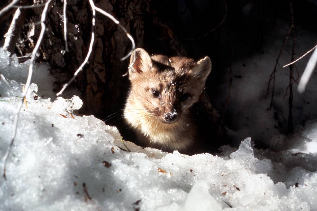 future conditions to inform conservation efforts for these species and to investigate how different modeling methods and resolutions may affect predictions about species’ responses to climate change. Martens and fishers are closely related forest carnivores of conservation concern in California, where both reach their southernmost distributions. The species have contiguous elevation ranges, with the smaller marten occupying high subalpine forests that experience deep and persistent snow, and the larger fisher occupying mid-elevation forests that experience less snow and warmer temperatures.
The goals of this project were to:
- add robust, downscaled, climate-change effects assessments to CBI’S Sierra Nevada Carnivores project, which is a comprehensive, science-based effort to map areas important to sustaining rare carnivore populations and improving forest management.
- compare alternative analytical approaches and resolutions for assessing climate impacts on vegetation and sensitive species.
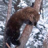 Because martens and fishers require similar forest structural conditions (dense forests with large trees and abundant dead wood) but different climate regimes (cooler, moister, and snowier conditions for martens; warmer, drier and less snowy conditions for fishers) they offer a unique opportunity to investigate how our changing climate may affect the species directly as well as via changes in vegetation. Also, because they compete with one another for food, and fishers will kill martens when they meet, this system offers an opportunity to investigate how species interactions may also affect future populations.
Specific study tasks:
- Examine how the current distributions of martens and fishers are influenced by vegetation characteristics (e.g., forest composition and structure), climate (e.g., temperature, precipitation, snow depth and duration), physical variables (e.g., elevation, % slope) and presence or absence of the other species.
- Project the potential future distribution of both species under climate change based on results of Task 1 and using alternative emissions scenarios and general circulation models at different resolutions.
- Use the results to support conservation and forest management plans to ensure long-term sustainability of marten and fisher populations in the face of climate change and increasingly severe fire regimes.
Click here for Methods, Outcomes, Interpretation and Related Data
National interest in roadless area conservation dates back to the 1970s when the Forest Service was directed by Congress to inventory roadless areas in response to the public’s growing desire to protect wild landscapes primarily through wilderness designations. In 2001, President Clinton enacted the Roadless Conservation Rule to protect 58.5 million acres of inventoried roadless areas on Forest Service lands, including nearly 2 million acres in Oregon. However, on May 13, 2005 the Bush administration issued a revised rule that established a process for governors to propose locally supported regulations for conserving roadless area within their states. While some states, including Oregon, have legally challenged this rule change, State governments will continue to play a vital role in providing recommendations to the Forest Service concerning the protection of federal roadless areas. This report provides new information on the importance of roadless areas in Oregon that places these areas among the most ecologically valued in the nation, thereby providing a scientific foundation for protecting all of Oregon’s roadless lands regardless of the method to achieve this outcome.
CBI staff outlined the crucial role that Southern Orange County, California, could play in efforts to conserve biodiversity at both global and regional scales and developed a conservation framework for the area. Using principles of conservation planning, they delineated four core biological resource units. That must be conserved essentially intact, without further internal fragmentation by development, to continue supporting key species and ecosystem processes. This information was presented by CBI, in support of the Natural Community Conservation Planning (NCCP) program for the Southern Orange County NCCP subregion, which is the last best hope to conserve a large, ecologically intact representation of the globally unique coastal foothills and terraces ecosystem of southern California.
The Puente-Chino Hills Wildlife Corridor is a peninsula of mostly undeveloped hills jutting about 42 km (26 miles) from the Santa Ana Mountains into the heart of the densely urbanized Los Angeles Basin. Intense public interest in conserving open space here has created a series of reserves and parks along most of the corridor’s length, but significant gaps in protection remain. These natural habitat areas support a surprising diversity of native wildlife, from mountain lions and mule deer to walnut groves, roadrunners, and horned lizards. But maintaining this diversity of life requires maintaining functional connections along the entire length of the corridor, so that wildlife can move between reserves—from one end of the hills to the other.
Already the corridor is fragmented by development and crossed by numerous busy roads, which create hazards and in some cases barriers to wildlife movement. Proposed developments threaten to further degrade or even sever the movement corridor, especially within its so-called “Missing Middle.” This mid-section of the corridor system, stretching from Tonner Canyon on the east to Harbor Boulevard on the west, includes several large properties proposed for new housing, roads, golf courses, and reservoirs. Such developments would reduce habitat area and the capacity to support area-dependent species and, if poorly designed, could block wildlife movement through the corridor.
This report builds on an impressive array of previous ecological and wildlife movement studies in the Puente-Chino Hills, as well as the general literature on wildlife movement corridors as it applies to this unique peninsula of wildness. It supplements the existing information with an analysis of gaps in protection—with special focus on the vulnerable Missing Middle—and recommends conservation and management actions to prevent further loss of ecological connectivity and retain native species.