The Forest Treatment Planner was developed to provide forest managers a platform for exploring the potential consequences of different forest management alternatives in both the short and long-term, examine the resource-based trade-offs inherent in any proposed vegetation management action, and clearly substantiate the rationale behind management planning. Originally envisioned as a means to help balance fisher habitat conservation with fuel reduction efforts, the Treatment Planner provides a dynamic link between GIS, the Forest Vegetation Simulator (FVS) modeling software, and any resource model (e.g. habitat, hydrology, fuel, economic) that uses the EEMS (Environmental Evaluation Modeling System) modeling environment. As such, the Treatment Planner is not a model per-se, but a system of communication between existing software that, when used together, can facilitate spatially-explicit comparisons and project refinement. By exporting an FVS output directly into the EEMS modeling environment, this framework allows for a transparent evaluation of the impacts to multiple resource values and a straightforward process for communicating these impacts to stakeholders.
The Treatment Planner supports an iterative process of treatment project simulation, adaptive management, and outcomes analysis, the steps in what we refer to as the “4-Box” decision making framework. The 4-Box model is a conceptual representation of a process designed to help predict future landscape conditions based on simulated management actions and change over time (see Figure). In this process, the forest manager first examines the current conditions of the landscape through the lens of a particular question or management objective (e.g., where is there a need for protection or restoration?). They can then explore the predicted effects of various simulated management alternatives (e.g., thin from above, or thin from below), to see how they would affect the stand structure (e.g., stand density, basal area, and average DBH) over time, both immediately and into the future. Finally, the manager can examine how those new conditions would then affect a particular phenomenon of interest such as, severe fire risk, or wildlife habitat suitability. This process is then repeated under a different set of treatment options (scenarios) to inform the development of an effective management strategy.
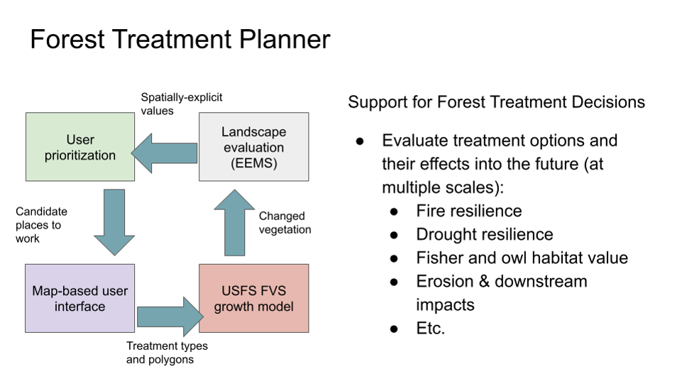
Figure 1. The 4-Box model represents a process for evaluating future conditions based on simulated treatments and change over time.
You can check out the detailed steps to use the treatment planner using the document on the file tab. The relevant code for the treatment planner is available at github, click here to download.
As the Sierra Nevada town of Paradise rebuilds after the devastating Camp Fire of 2018, the community has an opportunity to incorporate strategies to increase its resilience to fire and climate change, enhance the safety and well-being of its residents, and at the same time care for the surrounding natural areas that make it a beautiful place to live.
CBI and the The Nature Conservancy helped Paradise seize this opportunity when the Paradise Recreation and Park District asked us to help them explore community design principles that could provide all of these benefits. The CBI team created geographic models of “Wildfire Risk Reduction Buffers” between the structures and the surrounding wildlands to reduce exposure of homes to wildfire risks. These buffers, which can be made up of parklands, orchards, and other low fire-risk land uses, can be managed to provide many benefits, including buffering homes from ignition, providing safe-haven refuges for residents to escape from fire, strategically-placed staging areas for fire-fighters, recreational access to open space, and protecting natural habitat from the effects of an encroaching urban landscape.
The team combined spatial data about the landscape with local knowledge to prioritize locations for fire risk-reduction and analyzed ignition risks and co-benefits with and without the buffers. The resulting maps illustrate the potential for local partnerships to make a real difference in the town’s future. Through innovative thinking about the role of land use planning, the community of Paradise is changing its approach to living with fire and providing a model for fire-prone communities everywhere.
The Conservation Biology Institute’s recent work with the Deschutes Trails Coalition (DTC) and the Deschutes National Forest focuses on designing a Trails Assessment and Planning Tool for Deschutes County. We have developed a blueprint for the design, in collaboration with the U.S. Forest Service and the DTC. In this new phase of the project, funded by the U.S. Forest Service, CBI will partner with the DTC to build a prototype of the trails decision-support tool and sustainability model for Deschutes County. Then we will scale up and customize this prototype to meet the requirements of the U.S. Forest Service and its partners in the states of Oregon and Washington. The Trail Assessment and Planning Tool design includes creating a preliminary version of a sustainability framework that incorporates an interactive spatially-explicit model, addressing the physical, environmental, social, and economic aspects of sustainability. The model is powered by CBI’s Environmental Evaluation Modelling System (EEMS), allowing for its collaborative development with a diverse group of stakeholders, to create a transparent framework for local, regional, and national organizations to answer important questions relevant to trails planning and management.
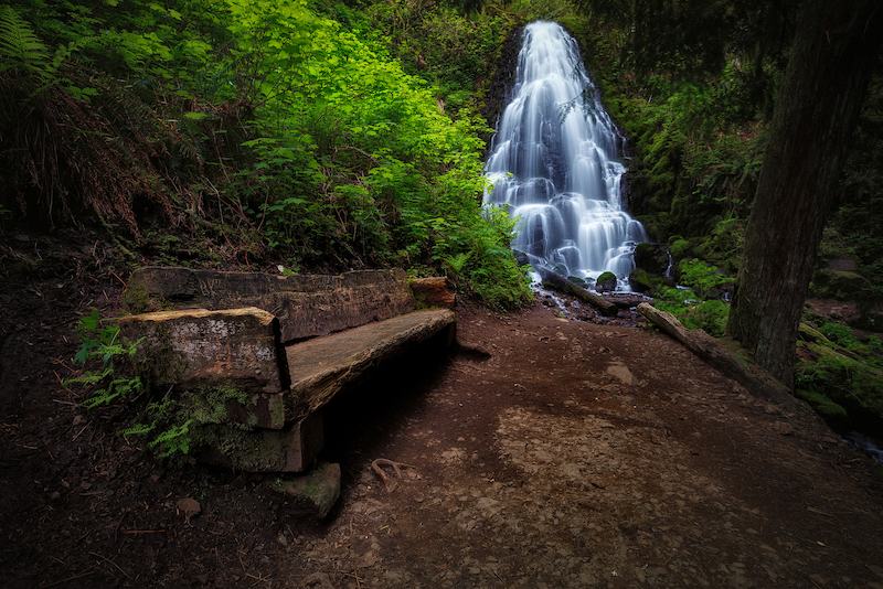
Proxy Falls, Oregon
Michael Riffle / Flickr
CBI is working in collaboration with Oregon State University, the University of Minnesota, and the University of Colorado Boulder on a project designed to help improve our understanding of post-fire community resilience. Central to the project will be the development of an RFID sensor network which will help support post-fire assessments of water infrastructure damage. These sensors will be deployed across a community’s freshwater pipeline network and will transmit data (e.g., temperature reached, pipeline material, exposure duration) that will help determine whether or not toxins have started leaching from the pipes into the freshwater supply. The current phase of the project focuses on Santa Rosa and Paradise in California where the 2017 Tubbs Fire and the 2018 Camp Fire caused damage to the water distribution systems, resulting in contaminated water within the system.
To help support this effort, CBI has developed a web application called the Wildfire Vulnerability Explorer, which can be accessed at https://wildfirevulnerability.eemsonline.org. This application allows users to explore a set of spatially explicit models developed for Santa Rosa and Paradise that identify areas likely to be vulnerable to water contamination exposure following a large-scale fire event. Estimates of vulnerability are based on three primary factors: the probability of water contamination, socioeconomic sensitivity, and adaptive capacity. The Wildfire Vulnerability Explorer brings this information together in an interactive map in order to help officials with both pre-fire planning and post-fire prioritization of recovery efforts – by identifying communities that are the most vulnerable to water contamination exposure, efforts can be taken to better plan for and direct resources to those areas.
Additional information about the project is available on the OSU project page at the link below:
Sensor Technology for Improved Wildland Urban Interface (WUI) Fire Resilience
Funding for the project was provided by the Alfred P. Sloan Foundation.
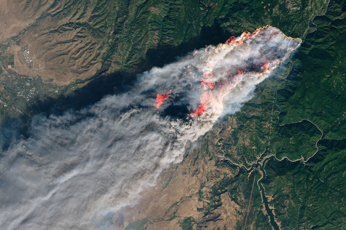
Photo courtesy of NASA (https://earthobservatory.nasa.gov/images/144225/camp-fire-rages-in-california): Camp Fire in Paradise, California, which is one of the project study areas.
Conservation Biology Institute is a partner in a new $1 million grant from a new interdisciplinary NSF program to foster building an “open knowledge network.” The inspiration for this type of network comes from Tim Berners-Lee’s (best known founder of the World-wide Web) vision for the “semantic web,” which applies tags with relationships to information on the Internet, allowing computers to do basic reasoning for improving search results and answering questions. Apple’s Siri, Amazon’s Alexa, and Google’s Assistant all use these technologies.
Dr. John Gallo co-wrote the proposal and leads CBI’s participation in the team of 13 researchers and practitioners from 10 other institutions. The team is focused on improving access and contributions to tools for analyzing geographic data called spatial decision support systems. “The proliferation of online mapping technologies has greatly increased access to and utility of these kinds of tools, and a logical next step is increasing our ability to find the appropriate data and tools for your problem and link these together for more complex analyses,” says Principal Investigator Sean Gordon of Portland State University. Through engaging stakeholders in three applied case studies (the management of wildland fire, water quality, and biodiversity conservation), the interdisciplinary project team will develop and test participatory and automated methods for finding and sharing decision-relevant information using semantic web technologies.
The new NSF Convergence Accelerator program is named for its focus on bringing together interdisciplinary teams to address one of NSF’s 10 big ideas, specifically “Harnessing the Data Revolution“, also known as building an Open Knowledge Network. Eighteen other of these phase 1 grants were made, covering areas from molecular manufacturing to tracking potentially disruptive solar phenomena. The “accelerator” part comes from the short time frame. “The application required a 3-week turn around, which is very quick for a NSF grant,” Gordon said. “Our success was largely due to having formed the Spatial Decision Support Consortium, a professional networking group four years ago, so we had ideas and people ready to go.” Each phase 1 project is eligible to submit a phase 2 proposal for up to $5 million by next March, and the process will include giving a short “pitch” talk to a panel of experts and potential funders, much like a venture capital approach.
*Learn more about this ongoing project here.
The USDA Conservation Reserve Program (CRP) works with farmers and landowners to implement conservation management practices on enrolled lands, with paid contracts ranging from 10 to 15 years in length. The CRP Grasslands practices target restoration of agricultural grassland systems by augmenting native vegetation for pollinators, providing habitat for grassland plants and animals, increasing biodiversity, reducing soil erosion, and improving water quality. The USDA’s CRP has been successful in improving the conservation value of millions of acres of farmlands; however, the program currently lacks spatially explicit information on land cover and vegetation within CRP-enrolled tracts.
In partnership with the USDA FSA program, the Conservation Biology Institute (CBI) used a combination of remote sensing and machine learning algorithms deployed on the innovative cloud-computing platform, Google Earth Engine, to map grassland characteristics. We used a rich suite of enviro-climatic data, multiple sources of satellite imagery, and Random Forest modeling techniques to predict land cover for study areas in Washington, Colorado, and Kansas, where CRP Grasslands holdings are most prevalent. We used machine learning to create predictive maps of vegetation type by leveraging an extensive set of satellite-derived variables, environmental layers, and federal survey data (from BLM’s AIM and USDA NRCS’s NRI programs). Our initial investigation utilized Landsat 8 satellite data to model vegetation cover across the Washington study area and then scaled up to the Colorado-Kansas study area. The Washington study site was selected for further model enhancements and an in-depth comparison of Landsat 8, Sentinel-2, and MODIS satellite imagery, to evaluate differences in model development and performance among sensor types. We generated vegetation cover predictions for the year 2019 using Random Forest classification models. Classified outputs for the five vegetation cover models – annual grass, perennial grass, annual forb, perennial forb, and bare soil – were post-processed to exclude water and urban land cover and areas that were not relevant for mapping grasslands.
Mapped outputs showing vegetation percent cover predictions from our pilot project have been integrated into CBI’s CRP online decision support tool. This online tool offers functionality for managers and landowners to view, filter, compare and summarize geospatial information relevant for assessing CRP tracts in the study areas. You will need permission from USDA to use the tool, but it is available at https://crptool.org/. Anyone can view the design of the tool at USDA CRPtool.
You can read more details in the following publication.
Degagne, Rebecca; Pizzino, Declan; Friedrich, Hannah; Gough, Mike; Joseph, Gladwin; Strittholt, James; et al. (2022): Mapping Conservation Reserve Program Grasslands in Washington, Colorado, and Kansas with Remote Sensing and Machine Learning. figshare. Journal contribution. https://doi.org/10.6084/m9.figshare.19141853.v1
Cachuma Resource Conservation District (RCD) is working in partnership with Conservation Biology Institute, LegacyWorks, and Sharyn Main Consulting on the Regional Priority Plan to Reduce Wildfire Risk and Improve Forest Health in Santa Barbara County (RPP), which is a flagship project of the Santa Barbara County Conservation Blueprint. Funded by the California Coastal Conservancy, the RPP helps with the planning, mapping, and prioritization of projects that will proactively address wildfire threat in Santa Barbara County, as well as improve forest and habitat health.
The RPP is a multi-prong collaboration, which focuses on public and private land in the wildland/urban interface (WUI). CBI is the lead for a component of the project, to develop a sophisticated decision-support mapping tool to not only predict areas of high fire-risk on a landscape scale, but also help the community prioritize where fire risk mitigation projects should occur. The tool will serve as a community resource within the Santa Barbara County Conservation Blueprint and should improve communication, network building, and support community priorities through a regional approach to fire resilience and habitat health. The project team is talking with the many agencies and stakeholders involved, and facilitating the collaborative decision-making process.
Wildfires are a natural part of California ecosystems and play an important role in maintaining ecological structure and function. However, different fire regimes in the state have been altered due to past management practices, climate change, invasive species, and population growth and urban expansion. Given the potential for conflicts between fire management and conserving biodiversity and ecological functioning, solutions are needed to balance ecosystem health with human welfare and community safety.
CBI is partnering with Dr. Jon Keeley (USGS) and an international team of landscape ecologists, biologists, geographers and economists to study the factors that control wildfire activity in southern California, which experiences the largest number of housing losses to wildfire in the U.S. This work focuses on the role of different ignition sources, climate patterns, vegetation change, and housing location and arrangement in altering fire patterns and contributing to housing loss at the wildland-urban interface. Other topics of research include the effectiveness and effects of fuel treatments and prescribed fire in controlling large fire behavior; the role of homeowner practices, such as minimizing vegetation around homes and upgrading building construction materials to prevent house loss; and the relative importance of land planning decisions that could best minimize housing loss while preventing negative impacts to biodiversity.
While the research takes place primarily in southern California, the findings are applicable to other fire-prone non-forested ecosystems such as the Great Basin and the other Mediterranean-climate ecosystems across the world.
The results of this research are shared with management agencies like the National Park Service and U.S. Forest Service, in addition to local and state planners and policy makers, to identify the best strategies to increase community safety while minimizing effects on natural ecosystems.
nflicts between fire management and biodiversity conservation
Destructive wildfires are sudden, extreme events: In a matter of hours, both social and ecological communities are transformed by the loss of homes and lives, and change in natural vegetation. After such an event, residents take stock of their transformed landscape and environment, deciding to remain, rebuild, or move, while ecological communities restructure and regrow. These combined social and ecological responses to wildfire may present a ‘hot moment’ or ‘window of opportunity’ where governments, communities, and residents can take action to reduce the future exposure to disaster.
An interdisciplinary team of researchers, convened by CBI’s Dr. Alexandra Syphard, Dr. Miranda Mockrin from Northern Research Station, USDA Forest Service and Dr. Van Butsic, from the Department of Environmental Science, Policy, & Management at University of California, Berkeley, are examining the question “Do wildfires lead to transformative adaptation, reducing future wildfire risk or do they lead to entrenchment, as residents and institutions re-create hazard-prone environments?”
To examine this question, they will review national data of post-fire housing change (rebuilding, sales, new development, land subdivision) and investigate how social and ecological settings and impacts, as well as event characteristics, influence subsequent housing and ecological trends. They will also determine, at the household scale, how changes in housing patterns relate to the post-wildfire ecological setting and socioeconomic characteristics, determining adaptation or entrenchment.
Wildfire is an important ecological process in California, where a diversity of fire regimes shape the structure and composition of plant and animal communities. Fire regimes are changing beyond their historical range of variability, however, due to several factors, including past fire management, invasive species, land use change, and climate change. These changes not only threaten the integrity and diversity of biological communities, but affect human communities, too, as residential losses to wildfire have skyrocketed in the last several decades. Two of these drivers, land use and climate, are expected to change dramatically in the coming century, raising substantial concern about their effects on fire regimes and subsequent impacts to human communities and biological diversity.
CBI has partnered with University of California, Berkeley to develop and implement a scenario-based integrated modeling framework to quantify the relative importance of climatic and land use factors on current and future projected fire patterns and risk of structure loss for three study areas in California. Select research questions driving this project include:
1) How do patterns of fire activity vary by land use change and climate?
2) How does structure loss vary by land use and climate change?
3) How do these relationships varyby geographic region?
4) Given these relationships, how are large fires and associated structure risk likely to change in the future?
Results of the assembled model output will be distributed to appropriate stakeholders and Data Basin will host the mapped output data.