Wildfires are a natural part of California ecosystems and play an important role in maintaining ecological structure and function. However, different fire regimes in the state have been altered due to past management practices, climate change, invasive species, and population growth and urban expansion. Given the potential for conflicts between fire management and conserving biodiversity and ecological functioning, solutions are needed to balance ecosystem health with human welfare and community safety.
CBI is partnering with Dr. Jon Keeley (USGS) and an international team of landscape ecologists, biologists, geographers and economists to study the factors that control wildfire activity in southern California, which experiences the largest number of housing losses to wildfire in the U.S. This work focuses on the role of different ignition sources, climate patterns, vegetation change, and housing location and arrangement in altering fire patterns and contributing to housing loss at the wildland-urban interface. Other topics of research include the effectiveness and effects of fuel treatments and prescribed fire in controlling large fire behavior; the role of homeowner practices, such as minimizing vegetation around homes and upgrading building construction materials to prevent house loss; and the relative importance of land planning decisions that could best minimize housing loss while preventing negative impacts to biodiversity.
While the research takes place primarily in southern California, the findings are applicable to other fire-prone non-forested ecosystems such as the Great Basin and the other Mediterranean-climate ecosystems across the world.
The results of this research are shared with management agencies like the National Park Service and U.S. Forest Service, in addition to local and state planners and policy makers, to identify the best strategies to increase community safety while minimizing effects on natural ecosystems.
nflicts between fire management and biodiversity conservation
Destructive wildfires are sudden, extreme events: In a matter of hours, both social and ecological communities are transformed by the loss of homes and lives, and change in natural vegetation. After such an event, residents take stock of their transformed landscape and environment, deciding to remain, rebuild, or move, while ecological communities restructure and regrow. These combined social and ecological responses to wildfire may present a ‘hot moment’ or ‘window of opportunity’ where governments, communities, and residents can take action to reduce the future exposure to disaster.
An interdisciplinary team of researchers, convened by CBI’s Dr. Alexandra Syphard, Dr. Miranda Mockrin from Northern Research Station, USDA Forest Service and Dr. Van Butsic, from the Department of Environmental Science, Policy, & Management at University of California, Berkeley, are examining the question “Do wildfires lead to transformative adaptation, reducing future wildfire risk or do they lead to entrenchment, as residents and institutions re-create hazard-prone environments?”
To examine this question, they will review national data of post-fire housing change (rebuilding, sales, new development, land subdivision) and investigate how social and ecological settings and impacts, as well as event characteristics, influence subsequent housing and ecological trends. They will also determine, at the household scale, how changes in housing patterns relate to the post-wildfire ecological setting and socioeconomic characteristics, determining adaptation or entrenchment.
Wildfire is an important ecological process in California, where a diversity of fire regimes shape the structure and composition of plant and animal communities. Fire regimes are changing beyond their historical range of variability, however, due to several factors, including past fire management, invasive species, land use change, and climate change. These changes not only threaten the integrity and diversity of biological communities, but affect human communities, too, as residential losses to wildfire have skyrocketed in the last several decades. Two of these drivers, land use and climate, are expected to change dramatically in the coming century, raising substantial concern about their effects on fire regimes and subsequent impacts to human communities and biological diversity.
CBI has partnered with University of California, Berkeley to develop and implement a scenario-based integrated modeling framework to quantify the relative importance of climatic and land use factors on current and future projected fire patterns and risk of structure loss for three study areas in California. Select research questions driving this project include:
1) How do patterns of fire activity vary by land use change and climate?
2) How does structure loss vary by land use and climate change?
3) How do these relationships varyby geographic region?
4) Given these relationships, how are large fires and associated structure risk likely to change in the future?
Results of the assembled model output will be distributed to appropriate stakeholders and Data Basin will host the mapped output data.
CBI is collaborating with the United States Department of Agriculture (USDA) and the Farm Service Agency to produce an online application depicting ecological and economic features across Bottomland Hardwood Forest Conservation Reserve Program lands in the state of Mississippi. The Conservation Reserve Program (CRP) pays landowners to maintain these Bottomland Hardwood Forests providing important ecological benefits such as removing nitrogen and phosphorus from water, storing flood waters and reducing downstream flooding, trapping sediment, and promoting carbon sequestration. These benefits provided by the CRP are in addition to the restoration and enhancement of wetlands and wildlife habitat. The key ecological and economic features across these CRP lands will be estimated using remote sensing satellite imagery from the Sentinel satellite platform and machine learning modeling using a random forest approach. Additionally CBI staff will be conducting on the ground assessments of the ecological metrics during the 2019 field season.
By providing an online platform that provides metrics on these CRP lands, the USDA Farm Service Agency will be able to better monitor and evaluate existing acres of Bottomland Hardwood Forests that are part of the Conservation Reserve Program. This project is a pilot to determine the utility of the online platform and remote sensing methods, which if proven useful can be expanded to all regions where the CRP restores and enhances Bottomland Hardwood Forests.
The Random Forest modelling process was used to estimate various forest biometric measurements like biomass, density, height, etc., for CRP lands in Mississippi. These were also converted to economic values using standard procedures. We used Forest Inventory and Assessment (FIA) as training data and used field samples to augment the validation of the modelling process. Predicated outputs collected All these outputs were spatialized and incorporated into a customized tool for the USDA Conservation Reserve program.
The CRP tool allows USDA staff, land owners, and third-party organizations to view pertinent spatial information and guide decision making in relation to the status of CRP farms in Mississippi state. This tool allows one to summarize, filter and compare CRP farm tracts across counties and watersheds. You can also download reports in either of two appropriate formats (PDF or CSV). We have also included three different base layers, and relevant contextual data layers that you can view in relation to the CRP farm tracts. You will need permission from USDA to use the tool, but it is available at www.crptool.org. Anyone can view the design of the tool at https://www.sketch.com/s/feba6e2a-ff3e-4c3c-8d2d-9ea4f6bdc896.
CBI initially developed predictive maps of tree height, tree density, biomass, basal area, and forest type using Random Forest machine learning models. Numerous satellite-derived indices from the European Space Agency’s (ESA) Sentinel-1 and Sentinel-2 sensors, in addition to soils and topography data, were used as predictor inputs. We then refined these predictive models, focusing primarily on biomass improvements, by implementing new methods for processing Sentinel-1 imagery on the cloud computing platform Google Earth Engine (GEE); significantly updating model code; and incorporating preliminary data products derived from NASA’s spaceborne LiDAR mission – the Global Ecosystem Dynamics Investigation (GEDI). We refined the GEDI LiDAR-derived data products and included them in our models, and overall accuracy for the four forest regression models ranged from 57% to 91%. The Biomass model saw the greatest improvement in accuracy with the R2 increasing by 8%, from 49% to 57%. The Basal Area and Tree Height models both had minor 1-2% increases in accuracy, while the Tree Density model had no improvement. The Forest Type classification model had a negligible improvement in overall accuracy, however, the Elm/Ash/Cottonwood class increased in accuracy by ~6%, from 64% to 70%.
You can get more details in this publication. Degagne, R., Pizzino, D., Friedrich, H, Gough, M., Joseph, G., Iovanna, R., Smith, C. and Strittholt, J. 2022. Mississippi CRP Forest Remote Sensing with Preliminary Global Ecosystem and Dynamics (GEDI) Mission Derived Data Products. CBI Technical Report 2022-1. 40 pp. (10.6084/m9.figshare.19142147)
Scientists at The Wilderness Society (TWS), under the direction of Dr. Greg Aplet, are developing a collaborative conservation strategy that is especially pertinent during the new era of accelerated Climate Change. In short, the strategy is for society to designate a portfolio of three management strategies, zoned in large, contiguous areas across the landscape:
• Restoration zones where we try to repair the landscape and restore natural ecological patterns and processes that then can adapt to change
• Innovation zones in which the landscape is devoted to innovative management that anticipates climate change and guides ecological change to prepare for it; and,
• Observation zones in which the landscape is left to change on its own time to serve as a scientific “control” and to hedge against the unintended consequences of active management elsewhere.
The large contiguous areas are essential to minimize the deleterious edge effects that happen when the negative aspects of one zone bleed into the neighboring zone. The problem and the strategy are detailed more in a short article in the Pinchot Letter.
Given this strategy, a whole host of questions arise about where and how these zones should be mapped on the landscape. TWS has contracted Conservation Biology Institute (CBI) to help address these spatial challenges. The answers are context specific, so we are building a spatial decision support system (SDSS) to aid with these questions for any given landscape. A good SDSS combines information and human values in a systematic manner to provide maps, charts, and reports in a variety of easy-to-use formats, including within a web-browser. The CBI/TWS partnership is building a prototype SDSS now, using the Sierra Nevada mountains in California as a pilot study area. The SDSS is to be transparent, and customizable to the politics and ecology of a given region. Hence, we are building it on top of the Environmental Evaluation Modeling System (EEMS) using ArcGIS models and scripts, and the products are viewable to project advisors via Data Basin and EEMS Explorer (the EEMS graphical user interface in Data Basin).
Some of the methods and specifications for the foundation of the SDSS are as follows:
• A region of study is divided into a large set of spatially explicit reporting units (or planning units) that cover the region in entirety.
• The end user can choose from a variety of nested regions of study (such as the Sierra Nevada Forest Plan Reference Region, the Southern Sierra Nevada, or Sierra National Forest).
• The SDSS is to provide spatially explicit scenarios, each based on a set of parameter values and assumptions.
• For each scenario, each reporting unit in the study region is assigned to one of the three zones. This is to provide decision support, not decision making.
• Reporting units are selected for one zone or another based on both the composition of the unit as well as its spatial context.
Some of the details about the allocation algorithm are as follows:
• Many composition criteria can be considered; for now, there are 13 relating to the suitability and influence of pre-existing land designations, one regarding fire management, and 3 regarding ecological condition. For instance, Wilderness Areas are more suitable for the observation zone than the other two zones.
• A representation algorithm makes sure that reporting units allocated to each zone are distributed among one or several elevation bands, and several sub regions. (More geographic classes, such as habitat type, are pending.)
• A preliminary contiguity algorithm ensures that the allocations for each zone are clumped thereby minimizing fragmentation and deleterious edge effects.
• Addition of a CBI algorithm is pending that will further improve connectivity between core areas of each zone, thereby facilitating species movement within a zone during a changing climate.
The SDSS is currently in the Prototype stage that will undergo an evaluation and another round of development before release to partners. If anyone is interested in providing input, advice, and/or reviews on the work in progress at some point, or simply joining the announcement list, please contact Dr. Greg Aplet or Dr. John Gallo. Please contact Dr. Gallo regarding potential collaborations customizing the SDSS code and methodology for other types of multi-objective allocation projects.
The U.S. Forest Service, Oregon State University, and Conservation Biology Institute have collaboratively developed the Seedlot Selection Tool to help forest managers match tree seed collections (called seedlots) with planting sites to help ensure the resilience of forests in a changing climate.
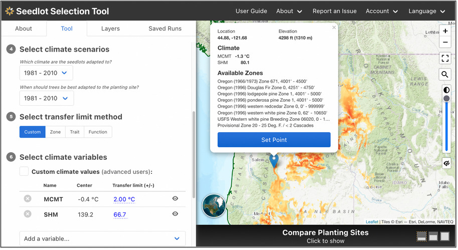
The Seedlot Selection Tool (or SST) is a free web-based decision-support tool that can be used to map planting locations based on either current climate data or a range of possible future climates across the conterminous U.S. and Mexico. Users can select a tree species, a climate scenario and relevant climate variables for the species, and other parameters to identify sources of seedlots appropriate for planting on a particular site or planting sites that are appropriate for planting seedlings from a particular seedlot. A valuable planning and educational tool, the SST helps explore possible future conditions, assess risk, and plan potential responses as part of a decision about which seedlot seedlings will be best adapted to a particular planting site in the future.
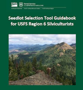
Seedlot Selection Tool Guidebook for US Forest Service Region 6 Silviculturists
Seedlot Selection Tool Video Tutorial for US Forest Service Region 6 Silviculturists
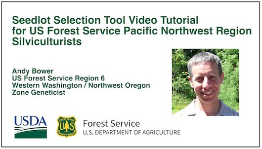
The SST was spearheaded by Glenn Howe at Oregon State University and Brad St. Clair at the USFS Pacific Northwest Research Station and developed by Nikolas Stevenson-Molnar, Brendan Ward, and Dominique Bachelet at CBI. Recently the USDA Climate Hub and USFS Region 6 staff worked with CBI to develop a step-by-step Guidebook and Video Tutorial for the Seedlot Selection Tool for Region 6 Silviculturists. These materials are useful to anyone who wants to learn about the use of this resource.
You may access the SST and detailed instructions at https://seedlotselectiontool.org/sst/.
Please see the USDA Climate Hub Seedlot Selection Tool Web Page for more information about the Guidebook and Tutorial Video.
Support for the SST came from the USFS, OSU, CBI, and the USDA Northwest Climate Hub.
CBI is providing scientific and technical support to Greenpeace Canada and AV Terrace Bay as they work together to maintain the ecological integrity of the Kenogami-Ogoki Forests in Ontario, Canada while providing a sustainable wood supply to the AV Terrace Bay mill and protecting cultural values of First Nations peoples.
There are two major, interrelated components of the project. First, CBI is examining a series of important aspects of woodland caribou conservation in the region, which has been a major focus throughout boreal Canada for a number of years as ongoing development is continually eroding woodland caribou habitat resulting in serious declines in some populations. Using data provided by the Ontario government, CBI is attempting to identify key caribou activity areas, regional movement patterns, and crucial habitat.
CBI is also creating a series of risk-based protected areas scenarios by defining areas of high landscape value and high biological value. High biological value is determined by considering representation of native ecosystems, overall forest values, concentrations of rare species, wetlands, and vital woodland caribou habitat.
Upon development of the scenarios, CBI will facilitate a discussion to review the trade-offs of the different scenarios between AV Terrace Bay and Greenpeace Canada, using Data Basin to support the discussion given the spatially explicit nature of the effort. In the end, the hope is to forge a land management agreement between the two parties that will allow for sustained economic development of the forest resources while protecting the ecological integrity of the region (including woodland caribou viability) and cultural values of the local First Nations peoples.
CBI investigated the effects of climate and vegetation on the distribution of martens (Martes caurina) and fishers (Martes pennanti) in the Sierra Nevada in California under current and projected 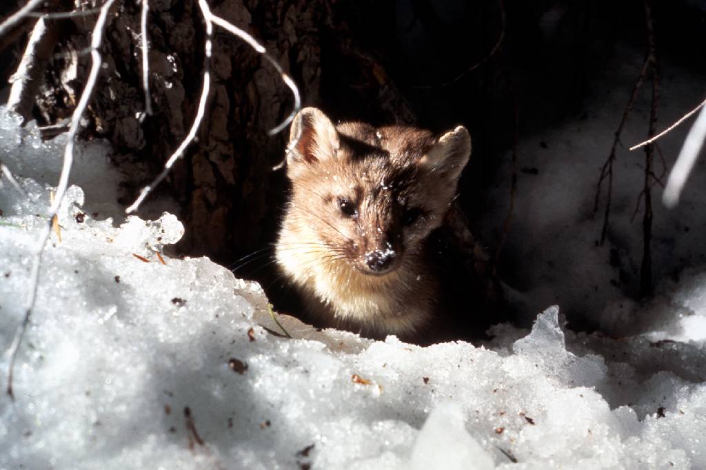 future conditions to inform conservation efforts for these species and to investigate how different modeling methods and resolutions may affect predictions about species’ responses to climate change. Martens and fishers are closely related forest carnivores of conservation concern in California, where both reach their southernmost distributions. The species have contiguous elevation ranges, with the smaller marten occupying high subalpine forests that experience deep and persistent snow, and the larger fisher occupying mid-elevation forests that experience less snow and warmer temperatures.
The goals of this project were to:
- add robust, downscaled, climate-change effects assessments to CBI’S Sierra Nevada Carnivores project, which is a comprehensive, science-based effort to map areas important to sustaining rare carnivore populations and improving forest management.
- compare alternative analytical approaches and resolutions for assessing climate impacts on vegetation and sensitive species.
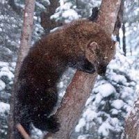 Because martens and fishers require similar forest structural conditions (dense forests with large trees and abundant dead wood) but different climate regimes (cooler, moister, and snowier conditions for martens; warmer, drier and less snowy conditions for fishers) they offer a unique opportunity to investigate how our changing climate may affect the species directly as well as via changes in vegetation. Also, because they compete with one another for food, and fishers will kill martens when they meet, this system offers an opportunity to investigate how species interactions may also affect future populations.
Specific study tasks:
- Examine how the current distributions of martens and fishers are influenced by vegetation characteristics (e.g., forest composition and structure), climate (e.g., temperature, precipitation, snow depth and duration), physical variables (e.g., elevation, % slope) and presence or absence of the other species.
- Project the potential future distribution of both species under climate change based on results of Task 1 and using alternative emissions scenarios and general circulation models at different resolutions.
- Use the results to support conservation and forest management plans to ensure long-term sustainability of marten and fisher populations in the face of climate change and increasingly severe fire regimes.
Click here for Methods, Outcomes, Interpretation and Related Data
This project is providing spatially explicit scientific foundations for forest management recommendations to sustain and enhance populations of four imperiled carnivores in the Sierra Nevada of California: marten (Martes americana), fisher (Martes pennanti), wolverine (Gulo gulo), and Sierra Nevada red fox (Vulpes vulpes necator). The recommendations focus on enhancing resiliency of existing populations over the next 15-20 years, and assessing strategies for adaptation to climate change in the longer term.
Products include maps depicting habitat value and distribution for each species, lands important to maintaining population connectivity and movement potential between habitat areas, and lands important to accommodating shifts in distribution under climate change. These maps will serve as foundations for spatially explicit conservation, management, and restoration recommendations, which can be incorporated into National Forest Management Plans and other land use and management plans.
This project will produce decision-support maps and tools to support an Interagency Fisher Biology Team in developing and implementing a Conservation Strategy for the west coast fisher Distinct Population Segment (DPS)–a Candidate for listing under that Endangered Species Act that stretches from southern British Columbia through Oregon, Washington, and California. The Interagency Fisher Team includes representatives of the US Fish and Wildlife Service, US Forest Service, and other Federal, State, and Provincial agencies with an interest in species conservation and forest management.
CBI will prepare maps, analyses, and other decision-support tools, including habitat value, habitat connectivity, and population distribution maps for the DPS under current conditions, and an assessment of climate-change effects on fisher habitat and populations in the future. These types of spatially explicit decision-support tools are needed to inform conservation planning and adaptive management to sustain and restore habitat value and fisher populations within the fisher DPS.