As the Earth’s climate changes, many plant and animal species are reacting by shifting their geographic ranges. As a result, resource managers are now faced with the challenge of developing and implementing strategies that will support wildlife adaptation to climate change. The sheer magnitude and diversity of models and data that can be applied to climate impact analyses and adaptation strategies can often be confusing to many users.
Recognizing a need for clarity within this field, the Yale School of Forestry and Environmental Sciences convened a working group of the nation’s leading conservation biologists, modelers, and policy makers to develop a guidance tool for integrating natural adaptation strategies into the context of natural resource planning and policymaking. The tool, The Yale Mapping Framework (www.databasin.org/yale), assists resource managers in selecting the assessment and modeling strategies that are most relevant to their specific needs, helping to guide choices among the many tools, data, and methods that planners may use to implement their adaptation approaches in the face of a changing climate.
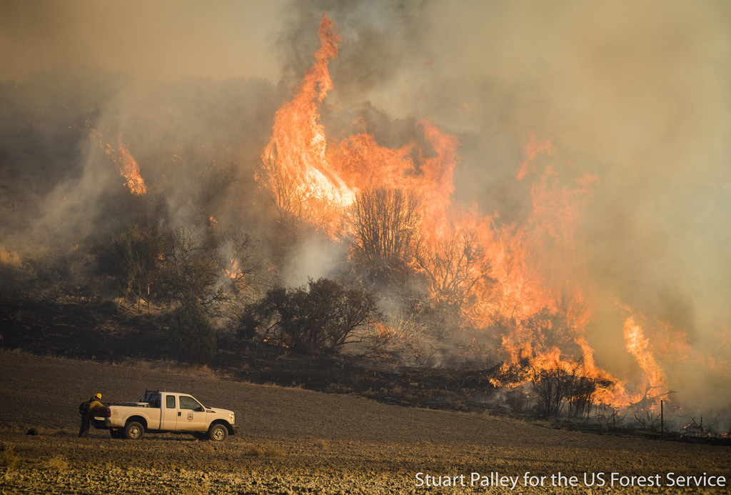
This report assesses potential impacts of feral pig populations in southern California (San Diego, Riverside, Imperial, and Orange counties) and Baja California, with an emphasis on San Diego County. We compiled information on the status of pigs in these areas from the literature and interviews with numerous individuals knowledgeable about feral pig populations, including a population recently introduced into San Diego County. We also reviewed available information on the potential impacts of feral pigs on natural resources, water systems, agriculture, and human health, and discussed the feasibility of various control and eradication options.
We developed population and habitat suitability models for feral pigs in San Diego County to examine the potential for numeric and geographic expansion following the recent introduction near El Capitan Reservoir. The models suggest that the population has the potential to grow rapidly and expand into large expanses of currently unoccupied habitat. Such expansion could harm natural biological resources, including riparian and oak woodland communities and numerous sensitive species. It is possible that populations could establish in such protected lands as Cuyamaca Rancho State Park and Volcan Mountain Preserve, as well as various wilderness areas. This could greatly diminish and possibly nullify large conservation investments already made in this region, including habitat restoration efforts. Finally, an expanding feral pig population in San Diego County could invade and cause grave damage in Baja California, where feral pig populations have not, to date, been reported.
CBI staff are leading a large team of mammal experts in preparing a comprehensive review of the conservation status of all mammal species, subspecies, and distinct population segments in California. The team has developed and applied a systematic scoring procedure to rank mammal species, subspecies, or distinct population segments for their relative degree of conservation concern within California. They compiled all available locality data and other pertinent information concerning the status and distribution of nominee taxa, and are preparing species accounts and geographic range maps for each taxon that made the final list. The result will be used to update Department of Fish and Game’s official list of sensitive taxa and will be published in book and web formats.
Click here to access the Mammal Species of Special Concern (MSSC) website
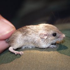
Photo credit: Steve Montgomery
CBI staff verified a new population of the endangered Stephens’ kangaroo rat in the Santa Maria Valley, San Diego County, California, by trapping and reconnaissance surveys and performed numerous adaptive management and monitoring tasks to help sustain this isolated population. Tasks included:
- Mapping the density and extent of population
- Performing GIS habitat modeling to predict other potential habitat in the region
- Providing tissue samples for genetic analyses, which demostrated that the population is unique and highly inbred
- Preparing a Biological Assessment for the expansion of the Ramona Airport in the heart of the population and a Habitat Management Plan to sustain the population via adaptive management and monitoring
- Preparing and implementing a translocation program to salvage kangaroo rats prior to construction of an expanded airport runway through the heart of the population, house them in captivity, release them to improved habitat areas, and monitor success of the translocated population and the overall population in the area for several years
The fisher (Martes pennanti) is a large member of the weasel family associated with dense, structurally complex, low- to mid-elevation forests. Remaining populations in the western U.S. are small, disconnected from one another, and threatened by habitat modification and fragmentation. In 2008 fishers occupied less than half their historic range, having apparently been extirpated from the central and northern Sierra Nevada. A small population persist in the southern Sierras, south from Yosemite National Park to the vicinity of the Greenhorn Mountains in southern Tulare County.
The Conservation Biology Institute (CBI) was commissioned by Region 5 of the U.S. Forest Service to compile all available data on fisher populations and habitat in the southern Sierra Nevada, assess their current status, and predict how they are likely to respond to various alternative forest management actions, as well as unmanaged events such as wildfires, drought, or bark beetle outbreaks. The project was designed to create a scientifically credible set of habitat maps and estimates of fisher population size and distribution in the southern Sierra Nevada based on current conditions and likely future change under a range of alternative scenarios.
A group of independent science advisors was assembled to oversee the technical aspects of the analysis and ensure use of best available science. Stakeholder groups were kept informed via stakeholder representatives from the timber industry, conservation organizations, the US Fish and Wildlife Service, California Department of Fish and Game, and the various National Parks and Forests in the studya are. CBI worked closely with experts from the Pacific Southwest Reserach Station and Region 5 to ensure that the analysis accurately reflected proposed forest management actions.
The World Wildlife Fund has identified over 200 ecoregions (the Global 200) recognized for their high conservation priority, and calls for concentrated conservation planning in these regions. Not surprisingly, forested ecoregions constitute the majority of the Global 200.
Humans associate a wide array of values with forests. Historically, human interaction with forests has been predominantly destructive. Among the most important of these include:
- Conversion due to urbanization, agriculture, ranching, and mining
- Commercial exploitation of timber and wood pulp
- Local exploitation for firewood
- Human-altered distribution regimes (e.g. fire)
- Introduction of exotic species
- Construction of infrastructure facilities – particularly roads
Consequently, long-term forest conservation depends, at least in part, on large-scale forest restoration. The purpose of this report is threefold:
- Discuss the concept of forest restoration form a conservation biology perspective
- Outline the ecological characteristics, technical constraints, socio-political and economic influences, and overall restoration principles relevant to the Global 200 major habitat types and associated realms
- Place forest restoration within the larger context of worldwide forest conservation
The critically endangered Pacific pocket mouse (Perognathus longimembris pacificus), once thought extinct was rediscovered at 4 sites along the coast of southern California during the 1990s. CBI staff discovered one of the populations and led comprehensive efforts to identify all potential habitat areas and inform efforts to recover the species from the brink of extinction. Tasks included:
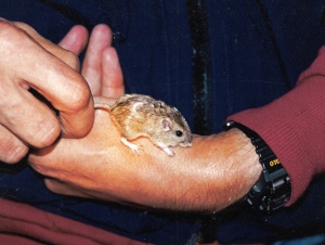
1) Studying dispersal characteristics and other pertinent biological information on the species
2) Performing detailed field studies of a surrogate subspecies to perfect field methods and design monitoring programs
3) Determining the feasibility of a translocation or reintroduction program for the species, determining baseline measures of genetic diversity within and between extant (using live-captured specimens) and historic (using museum specimens) populations and developing genetic goals for the recovery program
4) Coordinating ongoing monitoring studies at extant population sites to maximize the value of the monitoring data for both scientific and preserve management goals
Partners include Transportation Corridor Agencies, U.S. Fish and Wildlife Service, and California Department of Fish and Game.
Photo credits: Steve Montgomery (juvenile above) and David King (1995, Camp Pendleton)