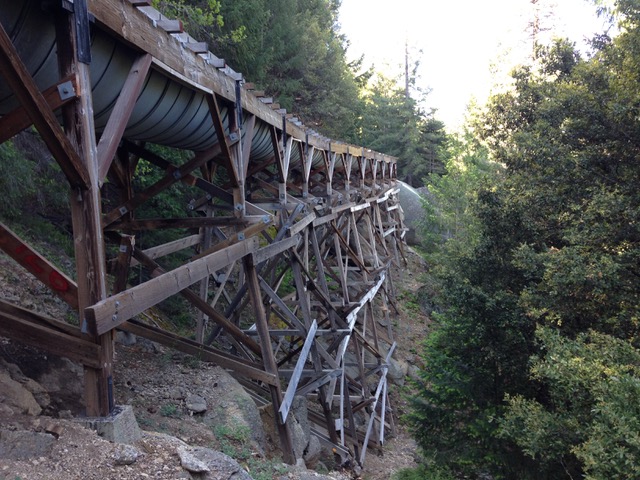
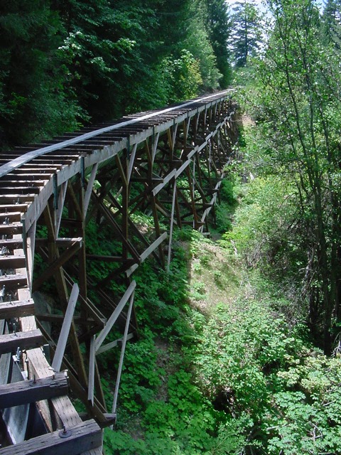
In the 1850s, immigrants seeking gold in California’s Sierra Nevada mountains created a connected network of open channels, wooden flumes, and pipes to direct water to their operations and the rapidly-growing foothill towns of Sonora, Columbia, and Jamestown.
170 years later, this historic system is an integral part of the water infrastructure that supports residential, agricultural, hydroelectric, ecosystem, and recreational purposes, providing nearly all of the drinking water to the west slope communities of Tuolumne County. Tuolumne Utilities District (TUD), the agency responsible for managing the 70-plus miles of raw water ditches and potable water infrastructure, is contending with a modern-day concern: the threat of severe wildfire.
Conservation Biology Institute and EN2 Resources, Inc. (en2resources.com/) partnered to develop the TUD Wildfire Defense Plan, which was adopted by Tuolumne Utilities District (TUD) in April of 2025.
This comprehensive strategy to protect Tuolumne County’s water resources and increase the community’s resilience to wildfire aligns with and implements the Tuolumne County Community Wildfire Protection Plan (CWPP). This plan also follows state and federal government directives relating to wildfire resilience for California’s communities and forests, including the California Wildfire and Forest Resilience Task Force’s Wildfire and Forest Resilience Action Plan and the U.S. Forest Service’s Wildfire Crisis Strategy Implementation Plan.
The TUD Wildfire Defense Plan contains two components:
TUD Wildfire Risk Mitigation Plan, prepared by CBI in consultation with TUD, presents prioritized locations for mitigating wildfire risks to TUD infrastructure and supports the effective planning and implementation of the prioritized projects while providing co-benefits to the community and natural resources.
The TUD Fire Water Draft Points Plan, prepared by EN2 Resources in consultation with TUD, identifies 49 strategic raw water draft points across the district to increase water availability for fire suppression, reduce demands on potable water systems, and enhance emergency response capabilities.Together these plans will help TUD manage the system as “green infrastructure”, a vision that addresses the integrated needs of people, the communities, and biodiversity under climate change. TUD, together with Pacific Gas & Electric, the US Forest Service, CAL FIRE, Tuolumne County, Tuolumne Fire Safe Council and the Tuolumne Band of Me-Wuk Indians are already working intensively to reduce fuels in the region, and this Plan will assist the agency in obtaining the funding needed to continue this important work.
The TUD Wildfire Defense Plan was developed with funding from the USDA Forest Service Community Wildfire Defense Grant. For more information about the TUD Wildfire Defense Plan, please visit https://tudwater.com/wildfire-defense-plan/.
The USDA Conservation Reserve Program (CRP) works with private landowners to advance conservation on their lands. This voluntary program currently comprises over 23 million acres making it an extremely important component of conservation in America, particularly in locations with limited public conservation lands. Management actions taken on enrolled lands include augmenting native vegetation for pollinators, providing habitat for grassland plants and animals, increasing biodiversity, reducing soil erosion, and improving water quality.
CBI is working with USDA to improve the effectiveness and efficiency of the program as it strives to expand enrollment in the coming years. Working in several pilot states (Mississippi, Kansas, Colorado, Washington, Nebraska, and the Dakotas), CBI is focusing on the following tasks:
- Create an online service open to the public that assists landowners to identify plant mixes most appropriate for their locations and management goals and vendors where seeds/seedlings can be acquired.
- For agency and CRP contract holders, create an online service that helps manage emergency haying/grazing requests.
- Develop and implement technology and protocols (e.g., phone field assessment app) that will involve contract holders more in the implementation of their agreements, which will provide important monitoring for improved program evaluation.
- Improve mapping and monitoring of forests and grasslands as they relate to CRP goals and objectives using the latest remote sensing technology, machine learning, and high-end processing resources.
- Conduct spatial analyses to help the program prioritize areas for more targeted enrollment.
- For agency users, provide an online service that allows for rapid and meaningful assessments of conservation management outcomes on CRP lands.
CBI Takes a Field Trip!
CBI headed to Jamestown, North Dakota, to speak with producers and USDA county staff regarding the USDA Mobile App, a tool designed for self-reporting, assessment, and communication surrounding CRP fields. We tested the app on over 35 fields to incorporate feedback from on-the-ground users, train remote sensing data, and test the effectiveness and ease-of-use of the tool. We coordinated with USGS, as well, testing this app on several of their pollinator plots, in conjunction with another CBI project.
Additionally, CBI traveled to Bismark and spoke with state NRCS staff, in order to hone and edit management questions and expand the usefulness of the app for reporting requirements and data gathering. Our experience was invaluable, as truthful reactions and deliberate responses from those who will eventually be using the tool, are critical in creating something that will be utilized and, ultimately, successful.
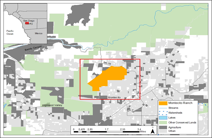
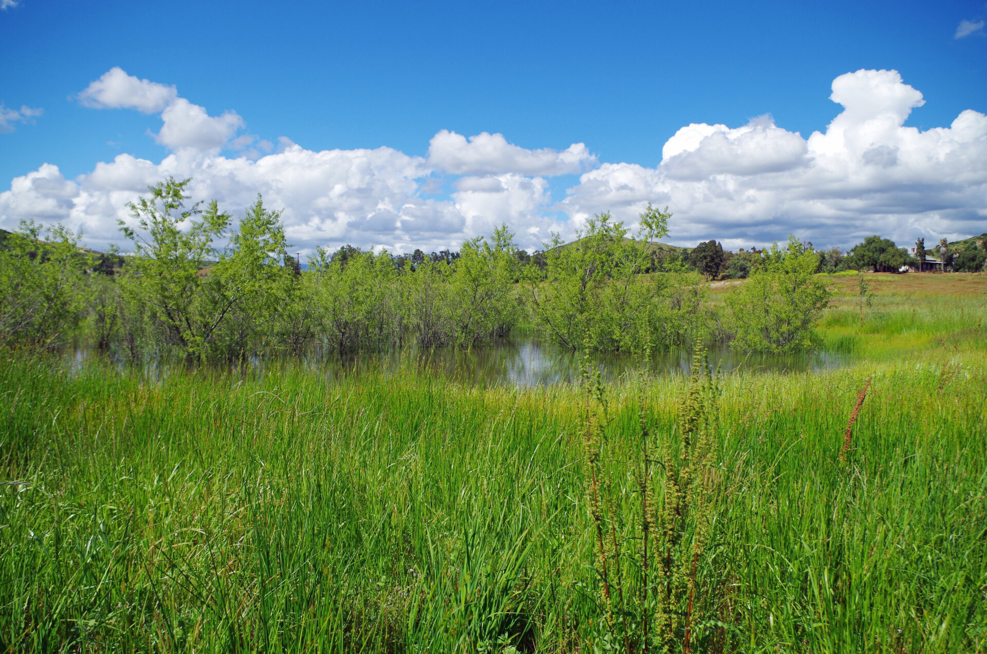
A Framework Resource Management Plan (F-RMP) for the Montecito Ranch Preserve was developed jointly by Jessie Vinje, CBI, Michael White, Endangered Habitats Conservancy (EHC), Steve Montgomery, ECORP Consulting, Inc., and the San Diego Management and Monitoring Program (SDMMP) in coordination with the United States Fish and Wildlife Service (USFWS), California Department of Fish and Wildlife (CDFW), and the U.S. Department of Defense. The F-RMP aligns preserve-level management and monitoring with the regional Management and Monitoring Strategic Plan (MSP Roadmap) for conserved lands in western San Diego County (SDMMP and TNC 2017). The MSP Roadmap provides regional and preserve-level goals and objectives for prioritized species, vegetation communities, and threats, and includes recommendations from regional planning documents. Together with its partners, CBI developed the F-RMP over 2.5-years by compiling and reviewing existing documents, literature, and spatial datasets, conducting rapid assessment surveys for biological resources, and meeting with species and regional experts.
The Preserve is a 955-acre perpetually conserved property located in west-central San Diego County near the town of Ramona. The Preserve is contiguous with the County of San Diego’s Ramona Grasslands County Preserve (Ramona Grasslands) and is located within the original Rancho Valle de Pamo (also called Rancho Santa Maria) Spanish land grant and on historical Kumeyaay land.
Montecito Ranch lies within the North County Multiple Species Conservation Plan (NCMSCP), a draft NCCP area, but was originally slated for development. EHC acquired the 955-acre ranch on June 10,2020, with funding from Section 6 of the Federal Endangered Species Act (ESA) of 1973, as amended. Specifically, two habitat conservation plan land acquisition grants associated with the County of San Diego Multiple Species Conservation Program (MSCP) were awarded funding for the acquisition of land that complements the MSCP and benefits covered listed and unlisted species. The California Wildlife Conservation Board (WCB) provided funding including the requisite non-federal matching funds for Section 6 grants and the U.S. Department of Defense provided 50% of the acquisition cost through its Readiness and Environmental Protection Integration (REPI) program, leveraged additional acquisition funding.
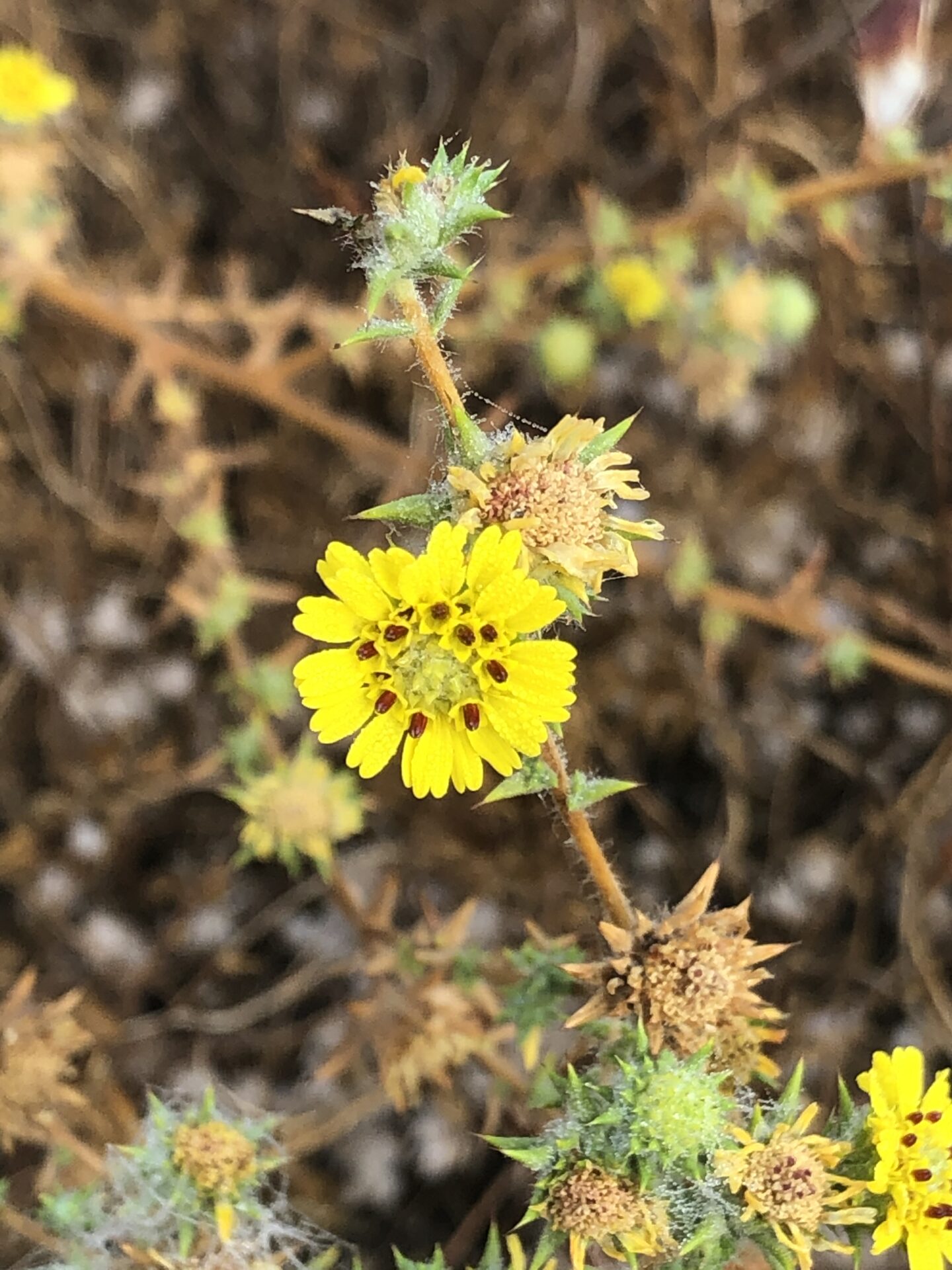
Montecito Ranch supports the federally threatened coastal California gnatcatcher (Polioptila californica californica), federally endangered San Diego fairy shrimp (Branchinecta sandiegoensis) and federally endangered Stephens’ kangaroo rat (Dipodomys stephensi) in addition to providing foraging and wintering habitat for raptors including golden eagle (Aquila chrysaetos canadensis) and other birds, and habitat for reptiles, amphibians, and mammals including American badger (Taxidea taxus). The Preserve supports vernal pools including the rare southern tarplant (Centromadia parryi subsp. australis), oak woodlands including the rare Engelmann oak (Quercus engelmannii), grasslands, coastal sage scrub, and chaparral habitats.
Linkage Mapper is a GIS toolbox designed to support regional wildlife habitat connectivity analyses. It consists of several Python scripts, packaged as an ArcGIS toolbox, that automate mapping of wildlife habitat corridors. The toolbox is comprised of six tools, described below.
The primary and original tool in the toolbox is Linkage Pathways. Linkage Pathways uses GIS maps of core habitat areas and resistances to identify and map linkages between core areas. Each cell in a resistance map is attributed with a value reflecting the energetic “cost”, (i.e. difficulty and mortality risk) of moving across that cell. Resistance values are typically determined by cell characteristics, such as land cover or housing density, combined with species-specific landscape resistance models. As animals move away from specific core areas, cost-weighted distance analyses produce maps of total movement resistance accumulated.
The Linkage Pathways tool identifies adjacent (neighboring) core areas and creates maps of least-cost corridors between them. It then mosaics the individual corridors to create a single composite corridor map. The result shows the relative value of each grid cell in providing connectivity between core areas, allowing users to identify which routes encounter more or fewer features that facilitate or impede movement between core areas. Linkage Pathways also produces vector layers that can be queried for corridor statistics.
The Columbia Plateau in eastern Washington supports productive farmland and rangeland as well as native shrub-steppe habitat of which only 40% remains intact. The region also contains some of the most sought after land in the state for utility scale solar energy development, which is an important component of its future energy portfolio that strives to produce 80% of the state’s electricity from renewable sources by 2030 and 100% carbon-free by 2040.
CBI has been chosen by the Washington State University Energy Program to provide the science and mapping component in support of a voluntary, collaborative effort that brings stakeholders together in order to identify areas of least-conflict between solar energy development and other important ecological, economic, and social values in order to meet the state’s carbon-free energy goals. CBI’s contribution to this process is based on the successful pilot to this approach in the San Joaquin Valley in California. The project will include a new Data Basin gateway, which is a customized site for accessing the science and mapping resources for this project.
See the recent brochure published by Washington State University for more information.
This report evaluates the impact that administrative and ecological constraints might have on the amount of forest biomass that could be extracted for energy use in the Southeastern U.S. Using available spatial datasets, we quantified and mapped how the application of various “conservation value screens” would change previous estimates of available standing forest biomass (Blackard et al. 2008). These value screens included protected areas managed for conservation values, USDA Forest Service and Bureau of Land Management (BLM) lands, steep slopes, designated critical habitat for federally-listed threatened and endangered species, inventoried roadless areas, old-growth forests, wetlands, hydrographic (lake, stream, and coastline) buffers, and locations of threatened and endangered species (G1-G3, S1-S3).
Two alternative combinations of values were examined: in Alternative 1, all areas within value screens, including all Forest Service and BLM lands, were excluded from biomass development. In Alternative 2, Forest Service and BLM lands not afforded extra protection by such designations as wilderness or research natural areas were assumed available for biomass extraction; all other values continued to be excluded from extraction. In both alternatives, biomass located within the Wildland-Urban Interface (WUI) was assumed available for extraction regardless of conservation value screens.
The analysis was conducted at 100-m x 100-m resolution. Summary statistics were derived at three scales – entire study area, 13 states, and 24 World Wildlife Fund (WWF) ecoregions. Results were also summarized and mapped for all 1,342 counties.
Finally, we compared hydrologic datasets at two different scales (1:24,000 and 1:100,000) at multiple sample areas in the study area to evaluate how hydrologic scale might affect the delineation of riparian reserves and resulting estimates of biomass availability.
CBI will develop and apply a forest management decision-support system (DSS) for forest resilience planning in the southern Sierra Nevada that integrates the latest science on how vegetation, terrain, climate, and weather interact to influence fire risks and forest resilience. The interdisciplinary team led by CBI includes ecological modelers, forest ecologists, fire scientists, physicists, and statisticians. The core of the DSS will be a Forest Resilience Model built using EEMS (Ecosystem Evaluation Modeling System; Sheehan and Gough 2016). The DSS will be tested, refined, and applied to resilience planning in that portion of the modeling region of greatest concern to the interagency Sequoia Regional Partnership, which is working to restore ecologically resilient conditions in and near Sequoia National Forest and Sequoia-Kings Canyon National Park.
The resilience model evaluates forest resilience to fire, drought, and other factors based on landscape conditions. The DSS will allow managers to simulate fuel-reduction treatments, evaluate their effects on a range of risks and resources (e.g., fire, sequoias, fisher habitat), project the impacts into the future, and assess levels of uncertainty. The DSS and component models will help managers understand how, in concert with terrain and weather, vegetation structure influences fire behavior and forest resilience. Importantly, the DSS will for the first time consider how fire-atmosphere coupling affects fire in models to support forest planning. This will apply how vegetation structure influences fire via both fuel arrangements and air flows, and thus more accurately reflect the full picture of how vegetation treatments may affect fire and fire effects on the landscape.
The DSS will be further refined and applied to resilience planning by the Sequoia Regional Partnership, whose primary focus is reducing fire risks to giant sequoia groves, fishers, and human communities.
External Team members include: Joe Werne (NorthWest Research Associates NWRA), Christopher Wikle (Department of Statistics, University of Missouri) and David Marvin (SALO Science).
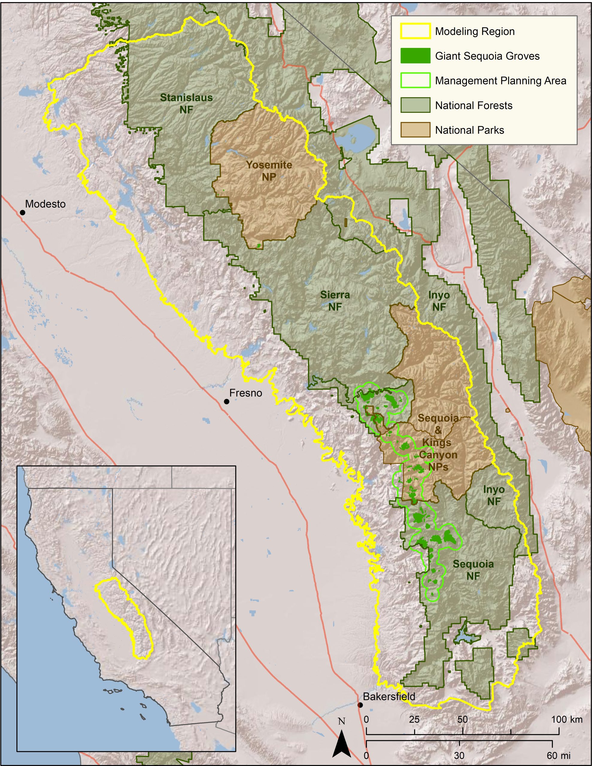 Map of project study area.
Conservation Biology Institute is supporting the Spatial Informatics Group – Natural Assets Laboratory (SIG-NAL) on a multi-year Regional Wildlife Mitigation Program (RWMP) in Santa Barbara county that is funded by the National Fish and Wildlife Foundation. Specifically, CBI in partnership with SIG-NAL will develop and propose a fire-resistant buffer or “greenbelt” area in strategic locations within the program area to create wildfire resilient green space, working lands, and habitats. Program outcomes will also provide numerous co-benefits that support watershed and coastal ecological health using a suite of tools including:
- Live oak shaded fuel breaks
- Habitat restoration
- Prescribed herbivory
- Hydrated and agricultural buffers
- Land Conservation
The RWMP is designed to assess hazard, exposure and vulnerability and equitably reduce wildfire hazard across the Santa Barbara front country. The program goals are to decrease the risk of wildfire impacts to structures and infrastructure, promote wildfire resilient green space, working lands, and habitats, and develop community capacity to adapt and recover from the shocks of natural disasters. The Program is divided into three primary Resilience Domains: the Landscape Resilience Domain, the Built Environment Resilience Domain, and the Community Resilient Domain. Each domain will work collaboratively to foster resilience and build adaptive capacity that will allow the community to prepare, respond and recover from the shock of large wildfires. More details can be found at this link: https://rwmpsantabarbara.org/.
As the Sierra Nevada town of Paradise rebuilds after the devastating Camp Fire of 2018, the community has an opportunity to incorporate strategies to increase its resilience to fire and climate change, enhance the safety and well-being of its residents, and at the same time care for the surrounding natural areas that make it a beautiful place to live.
CBI and the The Nature Conservancy helped Paradise seize this opportunity when the Paradise Recreation and Park District asked us to help them explore community design principles that could provide all of these benefits. The CBI team created geographic models of “Wildfire Risk Reduction Buffers” between the structures and the surrounding wildlands to reduce exposure of homes to wildfire risks. These buffers, which can be made up of parklands, orchards, and other low fire-risk land uses, can be managed to provide many benefits, including buffering homes from ignition, providing safe-haven refuges for residents to escape from fire, strategically-placed staging areas for fire-fighters, recreational access to open space, and protecting natural habitat from the effects of an encroaching urban landscape.
The team combined spatial data about the landscape with local knowledge to prioritize locations for fire risk-reduction and analyzed ignition risks and co-benefits with and without the buffers. The resulting maps illustrate the potential for local partnerships to make a real difference in the town’s future. Through innovative thinking about the role of land use planning, the community of Paradise is changing its approach to living with fire and providing a model for fire-prone communities everywhere.
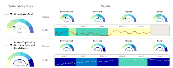
The Conservation Biology Institute’s recent work with the Deschutes Trails Coalition (DTC) and the Deschutes National Forest focuses on designing a Trails Assessment and Planning Tool for Deschutes County. We have developed a blueprint for the design, in collaboration with the U.S. Forest Service and the DTC. In this new phase of the project, funded by the U.S. Forest Service, CBI will partner with the DTC to build a prototype of the trails decision-support tool and sustainability model for Deschutes County. Then we will scale up and customize this prototype to meet the requirements of the U.S. Forest Service and its partners in the states of Oregon and Washington. The Trail Assessment and Planning Tool design includes creating a preliminary version of a sustainability framework that incorporates an interactive spatially-explicit model, addressing the physical, environmental, social, and economic aspects of sustainability. The model is powered by CBI’s Environmental Evaluation Modelling System (EEMS), allowing for its collaborative development with a diverse group of stakeholders, to create a transparent framework for local, regional, and national organizations to answer important questions relevant to trails planning and management.
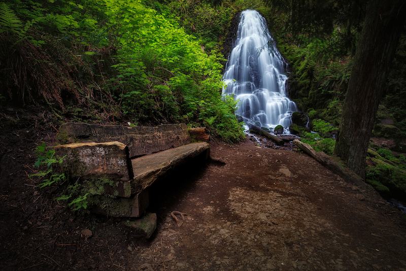
Proxy Falls, Oregon
Michael Riffle / Flickr