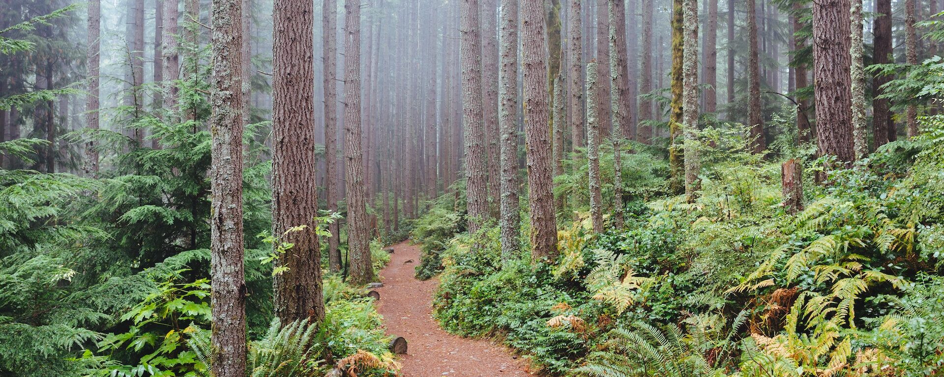
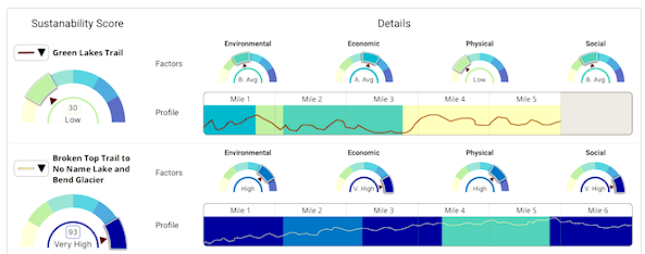
The Conservation Biology Institute’s recent work with the Deschutes Trails Coalition (DTC) and the Deschutes National Forest focuses on designing a Trails Assessment and Planning Tool for Deschutes County. We have developed a blueprint for the design, in collaboration with the U.S. Forest Service and the DTC. In this new phase of the project, funded by the U.S. Forest Service, CBI will partner with the DTC to build a prototype of the trails decision-support tool and sustainability model for Deschutes County. Then we will scale up and customize this prototype to meet the requirements of the U.S. Forest Service and its partners in the states of Oregon and Washington. The Trail Assessment and Planning Tool design includes creating a preliminary version of a sustainability framework that incorporates an interactive spatially-explicit model, addressing the physical, environmental, social, and economic aspects of sustainability. The model is powered by CBI’s Environmental Evaluation Modelling System (EEMS), allowing for its collaborative development with a diverse group of stakeholders, to create a transparent framework for local, regional, and national organizations to answer important questions relevant to trails planning and management.
Proxy Falls, Oregon
Michael Riffle / Flickr
CBI worked closely with the Natural Resource Defense Council (NRDC) to integrate relevant spatial datasets to map areas of high value from the standpoint of carbon storage and sequestration, terrestrial ecological value, and aquatic value in support of several NRDC programs, including their 30X30 campaign to protect 30% of nature in the nation by 2030. Click here to learn more about the 30×30 initiative.
Using CBI’s online modeling software called Environmental Evaluation Modeling System (or EEMS), team members were able to construct, review, and modify the models in a rigorous and highly transparent fashion from their individual remote locations. The resulting “living” models can then be used alone or together and in combination with other spatial data (e.g., existing protected areas) to add further context and insight using Data Basin. Data Basin and EEMS were effectively used to help guide NRDC’s important conservation mission.
CBI is working in collaboration with Oregon State University, the University of Minnesota, and the University of Colorado Boulder on a project designed to help improve our understanding of post-fire community resilience. Central to the project will be the development of an RFID sensor network which will help support post-fire assessments of water infrastructure damage. These sensors will be deployed across a community’s freshwater pipeline network and will transmit data (e.g., temperature reached, pipeline material, exposure duration) that will help determine whether or not toxins have started leaching from the pipes into the freshwater supply. The current phase of the project focuses on Santa Rosa and Paradise in California where the 2017 Tubbs Fire and the 2018 Camp Fire caused damage to the water distribution systems, resulting in contaminated water within the system.
To help support this effort, CBI has developed a web application called the Wildfire Vulnerability Explorer, which can be accessed at https://wildfirevulnerability.eemsonline.org. This application allows users to explore a set of spatially explicit models developed for Santa Rosa and Paradise that identify areas likely to be vulnerable to water contamination exposure following a large-scale fire event. Estimates of vulnerability are based on three primary factors: the probability of water contamination, socioeconomic sensitivity, and adaptive capacity. The Wildfire Vulnerability Explorer brings this information together in an interactive map in order to help officials with both pre-fire planning and post-fire prioritization of recovery efforts – by identifying communities that are the most vulnerable to water contamination exposure, efforts can be taken to better plan for and direct resources to those areas.
Additional information about the project is available on the OSU project page at the link below:
Sensor Technology for Improved Wildland Urban Interface (WUI) Fire Resilience
Funding for the project was provided by the Alfred P. Sloan Foundation.
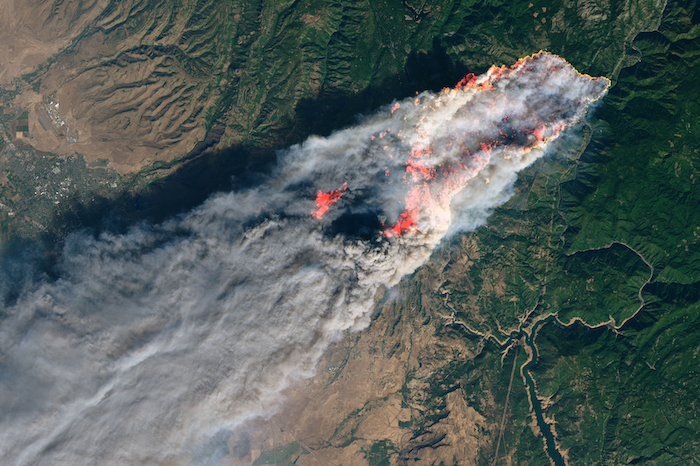
Photo courtesy of NASA (https://earthobservatory.nasa.gov/images/144225/camp-fire-rages-in-california): Camp Fire in Paradise, California, which is one of the project study areas.
In 2006, the Micronesia Challenge began as a commitment by the Republic of Palau, Guam, the Commonwealth of the Northern Mariana Islands, the Federated State of Micronesia, and the Republic of the Marshall Islands to preserve the marine and terrestrial resources crucial to the survival of the Pacific traditions, cultures, and livelihoods. The overall goal of the initial Micronesia Challenge was to effectively conserve at least 30% of the near-shore marine resources and 20% of the terrestrial resources across Micronesia by 2020.
During the 24th Micronesia Island Forum in 2019, the regional leadership recognized the success of the first 15 years of the Micronesia Challenge and endorsed the new Micronesia Challenge 2030 goals to effectively manage 50% of the marine resources and 30% of terrestrial resources by 2030.
In 2016, the USFS Forest Inventory and Analysis (FIA) team, regional partners and CBI developed the Micronesia Challenge Regional Terrestrial Monitoring Initiative tool (mcterrestrialmeasures.org) to allow users to visualize the spatial data from the Micronesia Challenge monitoring effort by regional framework indicator(s) that measure the status of managed conservation areas set aside under the program. The first version of the tool included forest data collected between 2003 and 2018 and determined the status and trends in forest area, forest health, understory vegetation, biomass, and carbon storage.
In this new phase of work, the Terrestrial Measure Initiative tool will be updated with the most recent data and information. The team also plans to develop a webinar presentation to communicate with local stakeholders and others about the tool and the ongoing success of the Micronesia Challenge.
CBI developed the tool for the Governor’s Office of Planning and Research (OPR) in coordination with the Department of Housing and Community Development. The tool was developed in partnership with OPR and is based on public input from partners through interviews, presentations, and workshops. Site Check is an innovative mapping tool that allows users to see if selected parcels may qualify for an existing streamlining option for housing development. The free tool allows users to map various CEQA definitions and filter parcels based on planning, transportation, and environmental criteria. Site Check is a good first step for developers and public agencies considering how California Environmental Quality Act (CEQA) may apply to a housing project. Check out the free tool here Site Check.
This tool is focused on the CEQA provisions that cover a variety of housing types. The Legislature has also created specialized provisions for specific types of projects, including affordable housing, agricultural employee housing, and motel-to-supportive housing conversions.
CBI updated the UI for the tool in 2023 and updated data, including the regional below-average Vehicle Miles Traveled (VMT), 15% below regional average VMT, parcel data, Specific Plans. Check these layers out in the tool or download them from Data Basin.
If you have any questions about Site Check, please feel free to contact Brianne Masukawa, brianne.masukawa@opr.ca.gov.
Conservation Biology Institute is working in partnership with Riverside County Habitat Conservation Agency, Bureau of Land Management, U.S. Fish and Wildlife Service, San Diego Zoo Wildlife Alliance Academy, and others to develop and implement a rangewide conservation plan for the Stephens’ kangaroo rat (Dipodomys stephensi, SKR), a tiny rodent native to Southern California’s shrinking grassland habitats.
The SKR Rangewide Management and Monitoring Plan, developed in collaboration with species managers, researchers, and land owners, complements existing management plans rather than replaces them, recognizing that each location has unique management priorities. Coordinating across local conservation efforts will facilitate collaborative conservation action across the species’ entire range.
The SKR Plan recommends management actions to improve habitat and ameliorate threats from human activities and climate change and provides a standardized monitoring protocol to track the species’ population status and trends. CBI has developed a customized field data collection application using ArcGIS Field Maps, and our SKR data management team supports the field monitoring effort and ensures long-term integrity of the data in partnership with USFWS’ Ecosphere Program.
This work builds upon a habitat suitability model developed in 2019 by Conservation Biology Institute using Sentinel-2 satellite imagery and being updated in time to support the 2024 monitoring season. These updatable landscape-scale habitat maps are the foundation for statistically-defensible monitoring and play a key role in planning coordinated conservation of the species.
This work is funded by the U.S. Bureau of Land Management. For more information about this effort, please contact Wayne Spencer at wdspencer@consbio.org or Brian Shomo at bshomo@wrcog.us.
Please see the SKR Rangewide Management and Monitoring Website for The SKR Rangewide Management and Monitoring Plan and Protocol, as well as other documents, maps, and data from this project.
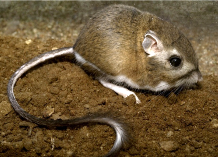
Stephens’ kangaroo rat (Dipodomys stephensi, SKR). Photo by Moose Peterson.
Conservation Biology Institute (CBI) and American Farmland Trust (AFT), the organization behind the national movement No Farms No Food®, continue to build off their previous work on the San Joaquin Land and Water Strategy. With the support from a Conservation Innovation Grant by the USDA Natural Resources Conservation Service, this phase of work focused on identifying priority areas for groundwater recharge in Madera and Stanislaus counties as well as the greater San Joaquin Valley.
CBI and AFT have compiled informative datasets related to soils, crop types, water infrastructure, and conservation areas in the San Joaquin Valley. These will be located in a San Joaquin Valley Gateway Gallery and mapping tool (with an associated manual) to aid in identifying optimal projects with the greatest potential to increase infiltration and conserve water. These datasets will provide a broad context that will allow for multiple benefits where possible such as locating conservation easements near currently protected areas in the productive farmland regions of Madera and Stanislaus counties, California.
The Project Prioritization Tool (PPT) is a conservation decision-making tool to increase the adoption of water infiltration practices, improve groundwater recharge, and protect agricultural land in the San Joaquin Valley (SJV). This PPT manual was developed by AFT and the Conservation Biology Institute (CBI) based on the data analysis of the San Joaquin Land and Water Strategy report.
Cachuma Resource Conservation District (RCD) is working in partnership with Conservation Biology Institute, LegacyWorks, and Sharyn Main Consulting on the Regional Priority Plan to Reduce Wildfire Risk and Improve Forest Health in Santa Barbara County (RPP), which is a flagship project of the Santa Barbara County Conservation Blueprint. Funded by the California Coastal Conservancy, the RPP helps with the planning, mapping, and prioritization of projects that will proactively address wildfire threat in Santa Barbara County, as well as improve forest and habitat health.
The RPP is a multi-prong collaboration, which focuses on public and private land in the wildland/urban interface (WUI). CBI is the lead for a component of the project, to develop a sophisticated decision-support mapping tool to not only predict areas of high fire-risk on a landscape scale, but also help the community prioritize where fire risk mitigation projects should occur. The tool will serve as a community resource within the Santa Barbara County Conservation Blueprint and should improve communication, network building, and support community priorities through a regional approach to fire resilience and habitat health. The project team is talking with the many agencies and stakeholders involved, and facilitating the collaborative decision-making process.
CBI recently worked with the Pacific Marine & Estuarine Fish Habitat Partnership (PMEP) to update the West Coast Estuaries Explorer, a tool designed to engage a broad range of users with detailed information about estuaries along the U.S. West Coast. The first version of this tool was developed in partnership with PMEP and the North Pacific Landscape Conservation Cooperative. The partnership between CBI and PMEP continues with support from NOAA and the Pacific States Marine Fisheries Commission (PSMFC). The Estuaries Explorer got several performance and design updates to make it easier to use and more visually engaging. In addition to the latest available information for estuary boundaries and biological habitats, the Explorer now includes aerial images for each of the estuaries in Washington, Oregon, and California. Later this year, CBI and PMEP will incorporate additional information on the location of eelgrass habitat and areas of tidal wetland loss. PSMFC has taken over long-term hosting of this exciting tool.
Conservation Biology Institute is a partner in a new $1 million grant from a new interdisciplinary NSF program to foster building an “open knowledge network.” The inspiration for this type of network comes from Tim Berners-Lee’s (best known founder of the World-wide Web) vision for the “semantic web,” which applies tags with relationships to information on the Internet, allowing computers to do basic reasoning for improving search results and answering questions. Apple’s Siri, Amazon’s Alexa, and Google’s Assistant all use these technologies.
Dr. John Gallo co-wrote the proposal and leads CBI’s participation in the team of 13 researchers and practitioners from 10 other institutions. The team is focused on improving access and contributions to tools for analyzing geographic data called spatial decision support systems. “The proliferation of online mapping technologies has greatly increased access to and utility of these kinds of tools, and a logical next step is increasing our ability to find the appropriate data and tools for your problem and link these together for more complex analyses,” says Principal Investigator Sean Gordon of Portland State University. Through engaging stakeholders in three applied case studies (the management of wildland fire, water quality, and biodiversity conservation), the interdisciplinary project team will develop and test participatory and automated methods for finding and sharing decision-relevant information using semantic web technologies.
The new NSF Convergence Accelerator program is named for its focus on bringing together interdisciplinary teams to address one of NSF’s 10 big ideas, specifically “Harnessing the Data Revolution“, also known as building an Open Knowledge Network. Eighteen other of these phase 1 grants were made, covering areas from molecular manufacturing to tracking potentially disruptive solar phenomena. The “accelerator” part comes from the short time frame. “The application required a 3-week turn around, which is very quick for a NSF grant,” Gordon said. “Our success was largely due to having formed the Spatial Decision Support Consortium, a professional networking group four years ago, so we had ideas and people ready to go.” Each phase 1 project is eligible to submit a phase 2 proposal for up to $5 million by next March, and the process will include giving a short “pitch” talk to a panel of experts and potential funders, much like a venture capital approach.
*Learn more about this ongoing project here.