
CBI developed the tool for the Governor’s Office of Planning and Research (OPR) in coordination with the Department of Housing and Community Development. The tool was developed in partnership with OPR and is based on public input from partners through interviews, presentations, and workshops. Site Check is an innovative mapping tool that allows users to see if selected parcels may qualify for an existing streamlining option for housing development. The free tool allows users to map various CEQA definitions and filter parcels based on planning, transportation, and environmental criteria. Site Check is a good first step for developers and public agencies considering how California Environmental Quality Act (CEQA) may apply to a housing project. Check out the free tool here Site Check.
This tool is focused on the CEQA provisions that cover a variety of housing types. The Legislature has also created specialized provisions for specific types of projects, including affordable housing, agricultural employee housing, and motel-to-supportive housing conversions.
CBI updated the UI for the tool in 2023 and updated data, including the regional below-average Vehicle Miles Traveled (VMT), 15% below regional average VMT, parcel data, Specific Plans. Check these layers out in the tool or download them from Data Basin.
If you have any questions about Site Check, please feel free to contact Brianne Masukawa, brianne.masukawa@opr.ca.gov.
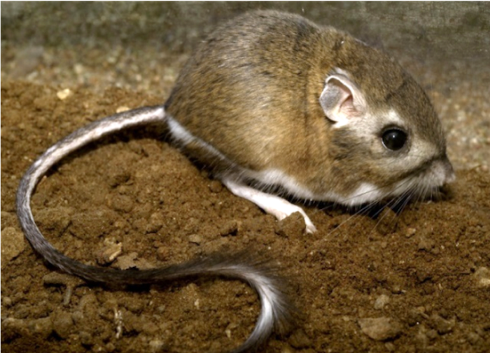
Conservation Biology Institute is working in partnership with Riverside County Habitat Conservation Agency, Bureau of Land Management, U.S. Fish and Wildlife Service, San Diego Zoo Wildlife Alliance Academy, and others to develop and implement a rangewide conservation plan for the Stephens’ kangaroo rat (Dipodomys stephensi, SKR), a tiny rodent native to Southern California’s shrinking grassland habitats.
The SKR Rangewide Management and Monitoring Plan, developed in collaboration with species managers, researchers, and land owners, complements existing management plans rather than replaces them, recognizing that each location has unique management priorities. Coordinating across local conservation efforts will facilitate collaborative conservation action across the species’ entire range.
The SKR Plan recommends management actions to improve habitat and ameliorate threats from human activities and climate change and provides a standardized monitoring protocol to track the species’ population status and trends. CBI has developed a customized field data collection application using ArcGIS Field Maps, and our SKR data management team supports the field monitoring effort and ensures long-term integrity of the data in partnership with USFWS’ Ecosphere Program.
This work builds upon a habitat suitability model developed in 2019 by Conservation Biology Institute using Sentinel-2 satellite imagery and being updated in time to support the 2024 monitoring season. These updatable landscape-scale habitat maps are the foundation for statistically-defensible monitoring and play a key role in planning coordinated conservation of the species.
This work is funded by the U.S. Bureau of Land Management. For more information about this effort, please contact Wayne Spencer at wdspencer@consbio.org or Brian Shomo at bshomo@wrcog.us.
Please see the SKR Rangewide Management and Monitoring Website for The SKR Rangewide Management and Monitoring Plan and Protocol, as well as other documents, maps, and data from this project.
Stephens’ kangaroo rat (Dipodomys stephensi, SKR). Photo by Moose Peterson.
Conservation Biology Institute (CBI) and American Farmland Trust (AFT), the organization behind the national movement No Farms No Food®, continue to build off their previous work on the San Joaquin Land and Water Strategy. With the support from a Conservation Innovation Grant by the USDA Natural Resources Conservation Service, this phase of work focused on identifying priority areas for groundwater recharge in Madera and Stanislaus counties as well as the greater San Joaquin Valley.
CBI and AFT have compiled informative datasets related to soils, crop types, water infrastructure, and conservation areas in the San Joaquin Valley. These will be located in a San Joaquin Valley Gateway Gallery and mapping tool (with an associated manual) to aid in identifying optimal projects with the greatest potential to increase infiltration and conserve water. These datasets will provide a broad context that will allow for multiple benefits where possible such as locating conservation easements near currently protected areas in the productive farmland regions of Madera and Stanislaus counties, California.
The Project Prioritization Tool (PPT) is a conservation decision-making tool to increase the adoption of water infiltration practices, improve groundwater recharge, and protect agricultural land in the San Joaquin Valley (SJV). This PPT manual was developed by AFT and the Conservation Biology Institute (CBI) based on the data analysis of the San Joaquin Land and Water Strategy report.
Cachuma Resource Conservation District (RCD) is working in partnership with Conservation Biology Institute, LegacyWorks, and Sharyn Main Consulting on the Regional Priority Plan to Reduce Wildfire Risk and Improve Forest Health in Santa Barbara County (RPP), which is a flagship project of the Santa Barbara County Conservation Blueprint. Funded by the California Coastal Conservancy, the RPP helps with the planning, mapping, and prioritization of projects that will proactively address wildfire threat in Santa Barbara County, as well as improve forest and habitat health.
The RPP is a multi-prong collaboration, which focuses on public and private land in the wildland/urban interface (WUI). CBI is the lead for a component of the project, to develop a sophisticated decision-support mapping tool to not only predict areas of high fire-risk on a landscape scale, but also help the community prioritize where fire risk mitigation projects should occur. The tool will serve as a community resource within the Santa Barbara County Conservation Blueprint and should improve communication, network building, and support community priorities through a regional approach to fire resilience and habitat health. The project team is talking with the many agencies and stakeholders involved, and facilitating the collaborative decision-making process.
Wildfires are becoming larger and more severe, causing negative impacts on our natural ecosystems. These post-fire impacts include invasions of exotic plants and an increase in the risk of mudslides, erosion, and siltation of important stream habitat. It is a daunting challenge for resource managers to determine where restoration can do the most good.
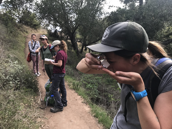
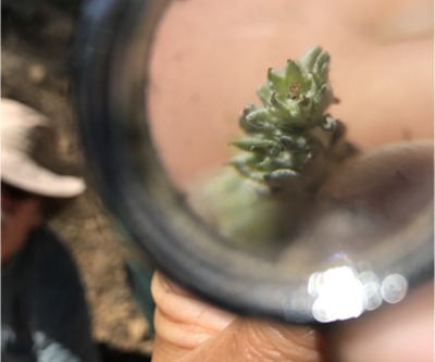
In this pilot project, CBI worked with the Santa Barbara Botanic Garden to develop and test online software coupled with a citizen-science process that helps resource managers identify the best candidate locations for restoration in the aftermath of the Thomas and Whittier Fires in Santa Barbara County.
Spatial data about the landscape are combined in a model that provides a preliminary prioritization map, which is then refined using field observations of professionals and community scientists in the Spring following a fire. The sites can then be visited in person to make the final decision about where to focus restoration efforts to maximize the return on the investment.
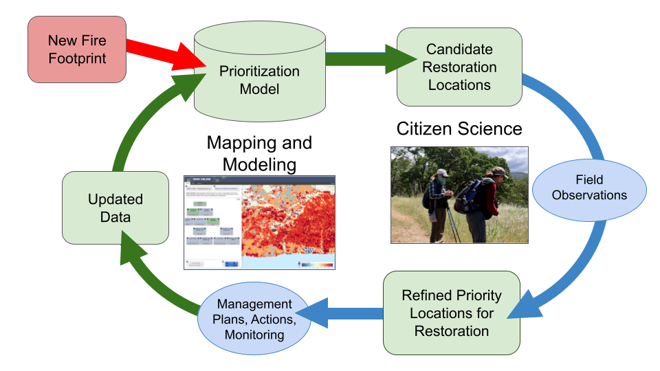
Figure 1. A flow chart displaying the steps involved in prioritizing areas for post-fire restoration
The community scientists used iNaturalist to record their observations and assist in identifications. You can see the more than 5,000 observations collected so far on iNaturalist here!
How You Can Learn More :
Watch this short video about the project.
View the model with prioritized restoration locations here.
Explore the restoration prioritization map together with other important data layers and photographs in Data Basin.
Read more technical details in this article.
Email john.gallo@consbio.org to be notified of community science opportunities when they arise.
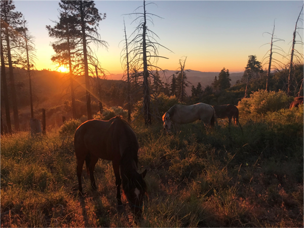
The Stephens’ kangaroo rat (Dipodomys stephensi) is an endangered mammal of grassland habitats in southern California. CBI is helping to conserve the species using satellite technology and advanced mapping techniques.
Kangaroo rats (or Krats, as biologists often call them) are seed-eating rodents restricted to arid regions of southwestern North America. The 20 or so Krat species are biologically similar to jerboas of the Mideast–and like mideastern jerboas and the kangaroos of Australia, they use their large hind limbs to bound efficiently and elusively through open habitats, especially deserts and grasslands. Being mostly nocturnal, Krats also have huge eyes for night vision and keen ears for hearing predators, like owls and foxes.
Stephens’ kangaroo rat (or biological shorthand, SKR) occupies open, undeveloped grasslands in western Riverside and San Diego counties in southern California. Because much of their habitat has been paved over and fragmented by development, the SKR was listed as Endangered under the the US Endangered Species Act and Threatened under the California ESA in the 1980s. Numerous ecological reserves have since been established to conserve remaining populations. Unfortunately, these scattered Krat reserves are not consistently managed, monitored, or even understood by the responsible resource management agencies, largely because it is difficult to map and track suitable habitat conditions over space and time. Traditional habitat variables, such as vegetation and soil types, are not nuanced enough to reflect the on-ground conditions that SKR need, and management and monitoring approaches differ amongst the reserves.
CBI is helping remedy this situation by using satellite imagery and innovative habitat modeling techniques to develop reliable statistical models to map habitat suitability across the species’ geographic range. In partnership with the US Fish and Wildlife Service, the Riverside County Habitat Conservation Agency (RCHCA), and species experts, we are developing a coordinated approach to mapping SKR habitat suitability to manage and monitor the species in a more scientifically consistent and justified manner. Specifically, we are using European Sentinel-2 satellite imagery, in concert with other reliable geographic data, to develop habitat suitability maps that can be routinely updated over time across the species range as conditions change. The resulting models will be used to inform management and monitoring efforts to conserve and recover this charismatic endangered species.
CBI is collaborating with the Rogue River-Siskiyou National Forest and the Klamath National Forest in their effort to conserve the Alaska yellow Cedar in its southern range, located in Southern Oregon and Northern California, where it faces extreme extinction risk due to climate change. Concerted conservation efforts are needed to develop and implement conservation and reforestation strategies, in order to manage forest tree species for sustainability in the future. CBI will help coordinate the collection of seeds from trees from 8 sites, tag and geo-reference each tree, gather information on the general health of these stands, and submit the seeds to the national seedbank in Fort Collins. In addition, current-year needles will be also collected from each seed tree for later genetic/genomics analysis by Richard Cronn and team at the Pacific Northwest Research Station of the USFS.
Alaska Yellow Cedar (Callitropsis nootkatensis) has an extensive range from Alaska to Northern California (Fig. 1). It is declining in the northern part of its range due to a combination of factors associated with climate change and is a rare species in the southern part of its range in California and Southern Oregon. These southern populations are relics that occur in isolated stands in sub-alpine zones in cool wet sites at higher elevation > 5000 ft (Fig 2). The species is currently under review for listing as a threatened or endangered species.
Update 12/18
CBI finished cone collections in September, 2018, from six populations across three sites in Southern Oregon and three sites in Northern California. Access to other sites was restricted due to the Klondike Fire burning in Southern Oregon. This completes the first systematic collection of mature cones from these southern populations.
We have recieved word from the US Forest Service, Bend Seed Extractory, located in Bend Oregon, that they have successfully extracted viable seeds. The next step is to send them to the National Seed Laboratory in Dry Branch, Georgia, USA. Once there, these seeds will be entered into the the national germplasm bank making these the very first entries for these relic southern populations.
Needle tissue that was collected from 10 trees at each site will be genetically analyzed by researchers at the USFS Forest Science lab in Corvallis.This analysis will help determine if these populations are genetically distinct sub-populations from their northern counterparts which will help guide conservation of this species.
The Rogue River-Siskiyou National forest office is planning to use some of these seeds to grow seedlings to test for certain traits such as disease resistance and drought tolerance. The hope is that seeds collected from these southern populations may be used for restoration plantings in the northern regions.
In the north, Alaska Yellow Cedar is a valuable timber species but has been declining as a result of the climate crisis.
Conservation of these southern populations may prove to be critical for the longterm management of northern Alaska Yellow Cedars on public and private lands.
Fig 1. Range map for Alaska yellow cedar.
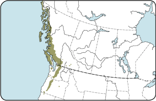
Source: http://tidcf.nrcan.gc.ca/en/trees/factsheet/376
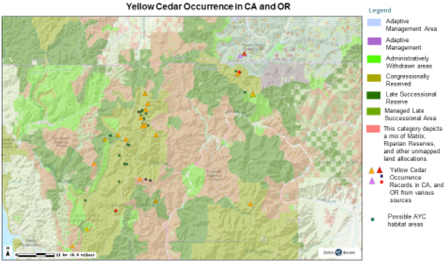
Figure 2. Current known yellow cedar locations in the Siskyou Mountains (CBI 2017)
Landscape connectivity is critical for species dispersal and population resilience. This project is part of the collaborative Landscape Conservation Design (LCD) for the Pacific Northwest coastal ecoregion and conducted in partnership with the North Pacific Landscape Conservation Cooperative. The goal is to identify connectivity pathways and prioritize corridors for 2-4 focal species West of the Cascades in Oregon and Washington. In Oregon, we will work closely with the members of the Oregon Habitat Connectivity Consortium (OHCC) for both the coastal and Willamette valley ecoregions of the state. The methods tested and refined in this project will feed into future Oregon-wide connectivity mapping.
To learn more and explore related maps and datasets, please visit the Data Basin gallery, “Connectivity of Naturalness in Western Washington“. The gallery includes outputs showing the structural connectivity (i.e. naturalness connectivity) for Western Washington.
These data can be used to help guide connectivity conservation efforts. They are the results from the pilot project comparing Omniscape (coreless) and Linkage Mapper (core areas) modeling methods. Extra attention was made to the data inputs and the rigor of the analyses so that the results can be applied, in addition to answering the driving research question.
Primary forests make up approximately one-third of the world’s remaining forests. Globally, they are grossly under-represented in protected areas and subject to industrial-scale logging and “sustainable forest management” that otherwise fragment intact areas. They face unprecedented threats from logging, mining, energy development, and climate change. British Columbia contains two globally important temperate rainforests with substantial primary and intact forest landscapes distributed from the coast (i.e. Great Bear Rainforest – GBR) inland (i.e., Inland Rainforest). Geos Institute proposes to map and assess conservation importance of the primary forests in these regions as a scientific basis for an international campaign aimed at protecting these globally important rainforests. CBI will support Geos Institute and partners in Canada to help map the area accurately, provide scientific input, and also do a carbon flux model for these primary rainforests.
In this project, CBI is a member of and also providing support to the Fort Bragg Headlands Consortium, with a mission to to help achieve environmentally sound restoration and development solutions that will improve the quality of life and economy for current and future residents of our Coast.
CBI’s major contribution to the Consortium is to develop and maintain the Fort Bragg Headlands web-mapping Gallery. Powered by Data Basin, this web-mapping Gallery is a feature-rich platform for local citizens, stakeholders and decision-makers to access publicly available spatial data (e.g. maps of streams, wetlands, hazards, soils, geology, etc.). This is timely, as Fort Bragg is currently making a significant Local Coastal Program (LCP) Amendment. Currently zoned Forest Light Industrial, these zoning changes will make the third of the city that was once a lumber mill into prime real estate zoned for profitable development. Fort Bragg is also figuring out how to deal with the remaining wetlands out there that still contain hazardous materials despite a first round of clean-up by the landowner. Providing easy access to data and maps will facilitate decisions that conserve the landscapes and biodiversity of the Fort Bragg region while bringing much needed development and jobs to sustain current and future generations. You can donate directly to this cause here.