Working with Oregon Department of Fish and Wildlife, Oregon Department of Transportation, US Fish and Wildlife Service, and other governmental and non-governmental partners, CBI is reviewing the current state of knowledge and is developing a wildlife and habitat connectivity blueprint for the State of Oregon, including the plan for generating a number of useful map-based products and online tools that will address planning at multiple scales across the state. This initial phase is expected to conclude in January 2018 with testing of the blueprint being carried out for a subset of the state (Coast Range and Klamath ecoregions) through different funding.
The Conservation Biology Institute will partner with The US Fish and Wildlife Service, Refuges Lands Division and North Pacific LCC, to develop an interactive web-based mapping tool to support the Willamette Valley Conservation Study (WVCS). This tool will be targeted to conservation partners in the region, as well as the general public. The primary objective of this web-mapping tool is to serve as a communication and data exploration tool for priority areas identified within the WVCS, and will allow users to understand the key characteristics of each priority area and better understand why each area was selected.
This tool will be developed and managed by CBI, alongside and embedded in the North Pacific LCC’s Conservation Planning Atlas (http://wvcs.apps.nplcc.databasin.org/).
CBI is playing a key role in improving the health and resilience of wetland ecosystems in Southern California in a partnership with the Southern California Wetlands Recovery Project (SCWRP). The newly-released Marsh Adaptation Planning Tool provides data access and decision-support technology for SCWRP’s new Regional Strategy 2018, a recovery plan for tidal and non-tidal wetlands from Point Conception to the Mexican border.
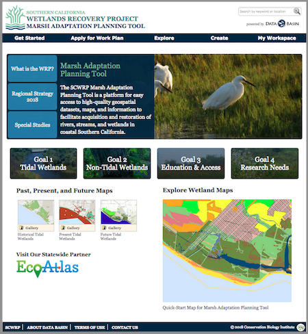
Above: The Marsh Adaptation Planning Tool homepage, with access to the Regional Strategy 2018, the spatial data that informed its development, and a special tool for planning projects that will contribute to its Work Plan.
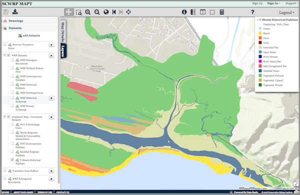
Above: The MAPT’s “Quick-Start Map” that allows the user to explore Southern California’s wetlands. Layers depicting historical and present-day wetlands, important transitions zones, and other features can be turned on and off for quick comparison. The map and its data layers can be downloaded for use in GIS, or saved and used with any other layers in Data Basin.
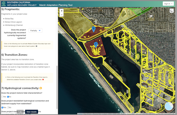
Above: The Marsh Adaptation Planning Tool’s project planning utility, where project proponents can use Regional Strategy 2018 spatial data, habitat types, and goals and objectives to inform the planning of a project and apply to have it included in the SCWRP Work Plan.
The Micronesia Challenge is a commitment by the Republic of Palau, Guam, the Commonwealth of the Northern Mariana Islands, the Federated State of Micronesia, and the Republic of the Marshall Islands to preserve the marine and terrestrial resources that are crucial to the survival of the Pacific traditions, cultures and livelihoods. The overall goal of the Micronesia Challenge is to effectively conserve at least 30% of the near-shore marine resources and 20% of the terrestrial resources across Micronesia by 2020. The USFS Forest Inventory and Analysis (FIA) team, regional partners and CBI developed the Micronesia Challenge Regional Terrestrial Monitoring Initiative tool (mcterrestrialmeasures.org) to allow users to visualize the spatial data from the Micronesia Challenge monitoring effort by regional framework indicator(s) that measure the status of managed conservation areas set aside under the program. Forest data were collected between 2003 and 2018 and are now being used to determine the status and trends in forest area, forest health, understory vegetation, biomass, and carbon storage.
CBI has partnered with the Paulson Institute (PI), the Foreign Economic Cooperation Office (FECO) of the Ministry of Environmental Protection of China (MEP), and the State of California to provide FECO with an Environmental Risk Screening Tool that will help guide Chinese international investment projects. The overarching goal of the tool is to significantly reduce negative environmental impacts as the result of Chinese development projects around the world.
The screening tool will include interactive mapping of biodiversity and environmental data against which potential development projects can be evaluated. The tool will include a standard Biodiversity Impact Analysis using a set of internationally recognized datasets (e.g., Key Biodiversity Areas, Critical Natural Habitat, Alliance for Zero Extinction sites, and Protected Areas). The tool will also include regional and country-level biodiversity and environmental data in priority countries. The tool is not available for viewing at present. But here is a powerpoint describing its capabilities.
Working closely with the Natural Resources Defense Council (NRDC), CBI conducted an assessment of the risk to the bottomland hardwood/wetland forests of the US Southeast to the growing threat from the wood pellet industry largely to fuel power plants throughout the European Union (EU). The final report released by NRDC was entitled, “In the U.S. Southeast, Natural Forests are Being Felled to Send Fuels Overseas“.
This report details the threats facing Southeastern U.S. Forests, which is widely recognized as one of the world’s biodiversity hotspots, from the wood pellet industry, which has seen a 150 percent increase in wood pellet exports between 2012-2015. The report explains that 24 million acres of unprotected Southeastern forest lands are at risk and predicts that pellet manufacturing could increase to be twelve times larger than it currently is by 2020. For a one-hour webinar dedicated to this topic, see Bioenergy Threatens Wetland Forests of the US Southeast.
CBI is providing science and technical support to assist the California Energy Commission (CEC) in planning the state’s future energy needs, which includes achieving aggressive renewable energy goals with minimal damage to natural systems. Building off of previous work completed for the Desert Renewable Energy Conservation Plan (DRECP), CBI is working to improve access and transparency of scientific data, maps and analysis. As a subset of the work, CBI is supporting the Renewable Energy Transmission Initiative 2.0 (RETI). RETI, according to the CEC, “is an open, transparent, and science-based process that will explore the abundant renewable generation resources in California and throughout the West, consider critical land use and environmental constraints, and identify potential transmission opportunities that could access and integrate renewable energy with the most environmental, economic, and community benefits.”
CBI is developing additional data, models, tools, and technical assistance that align with statewide energy and climate change adaptation planning. This work extends the information and tools previously built for the DRECP planning region to other areas of the state particularly in areas with high renewable energy potential.
Climate change and related impacts such as drought and wildfire are growing concerns throughout the state. In response, CBI is developing additional datasets and visualization applications to put this information into statewide context. CBI will deliver this data and information to the CEC and other California State agencies.
The Santa Barbara County Conservation Blueprint provides a common language and platform for publicly available data to support in depth conversations and informed decisions about the Santa Barbara County landscape. This collaborative project aims to describe the current landscape, natural resources, and community values about land in Santa Barbara County.
CBI is supporting this process for the Santa Barbara County region. The process is led by the Land Trust for Santa Barbara County, Cachuma Resource Conservation District, and the Santa Barbara Foundation’s LEAF Initiative to develop a Conservation Gateway for Santa Barbara County. This process is also guided by a 12-member Steering Committee representing agriculture, conservation, resource management, and the natural sciences.
This data gathering and community engagement process led to a Conservation “Blueprint” (including a Data Basin Gateway) that is providing a science based decision-making platform for future conservation in the county, including acquisition, restoration and guidance for other potential land management opportunities. In the long-term, this process is expected to include collective visioning, tool- sharing and collaborative strategies. The effort will strengthen the region’s integrity by building community, sharing information, and facilitating stewardship.
Visit www.sbcblueprint.net to learn more about the Blueprint project and explore the online Atlas.
The U.S. Forest Service, Oregon State University, and Conservation Biology Institute have collaboratively developed the Seedlot Selection Tool to help forest managers match tree seed collections (called seedlots) with planting sites to help ensure the resilience of forests in a changing climate.
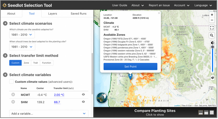
The Seedlot Selection Tool (or SST) is a free web-based decision-support tool that can be used to map planting locations based on either current climate data or a range of possible future climates across the conterminous U.S. and Mexico. Users can select a tree species, a climate scenario and relevant climate variables for the species, and other parameters to identify sources of seedlots appropriate for planting on a particular site or planting sites that are appropriate for planting seedlings from a particular seedlot. A valuable planning and educational tool, the SST helps explore possible future conditions, assess risk, and plan potential responses as part of a decision about which seedlot seedlings will be best adapted to a particular planting site in the future.
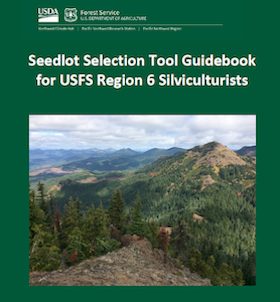
Seedlot Selection Tool Guidebook for US Forest Service Region 6 Silviculturists
Seedlot Selection Tool Video Tutorial for US Forest Service Region 6 Silviculturists
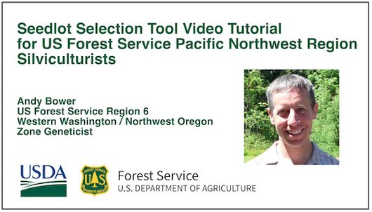
The SST was spearheaded by Glenn Howe at Oregon State University and Brad St. Clair at the USFS Pacific Northwest Research Station and developed by Nikolas Stevenson-Molnar, Brendan Ward, and Dominique Bachelet at CBI. Recently the USDA Climate Hub and USFS Region 6 staff worked with CBI to develop a step-by-step Guidebook and Video Tutorial for the Seedlot Selection Tool for Region 6 Silviculturists. These materials are useful to anyone who wants to learn about the use of this resource.
You may access the SST and detailed instructions at https://seedlotselectiontool.org/sst/.
Please see the USDA Climate Hub Seedlot Selection Tool Web Page for more information about the Guidebook and Tutorial Video.
Support for the SST came from the USFS, OSU, CBI, and the USDA Northwest Climate Hub.
CBI is expanding on previous work with the Peninsular Florida Landscape Conservation Cooperative (PFLCC) to further develop the PFLCC Simple Viewer to provide greater functionality and flexibility. In March 2017, CBI worked with PFLCC to incorporate PFLCC’s Blueprint version 1.0 into the viewer, and also created new reporting functionality to export on-screen results to PDF. In July 2017, CBI introduced the ability to aggregate multiple watersheds for display of summary information. This is particularly useful for users whose areas of interest and jurisdictions span multiple watersheds.
CBI is currently working on creating a Conservation Actions Tracker that will be added to the PFLCC Conservation Planning Atlas developed by CBI using Data Basin. This Conservation Actions Tracker will to allow users throughout Florida to enter information about conservation actions on the landscape – such as restoration activities – using an intuitive map-oriented interface. Users will also be able to explore any conservation actions in the system, and discover opportunities for collaboration and shared impact.
CBI is in the process of designing a new interactive application to showcase the PFLCC climate change adaptation guide so that users will be able to use interactive maps and data visualization to gain a greater understanding of climate change adaptations within Florida landscapes.