
The U.S. Forest Service, Oregon State University, and Conservation Biology Institute have collaboratively developed the Seedlot Selection Tool to help forest managers match tree seed collections (called seedlots) with planting sites to help ensure the resilience of forests in a changing climate.
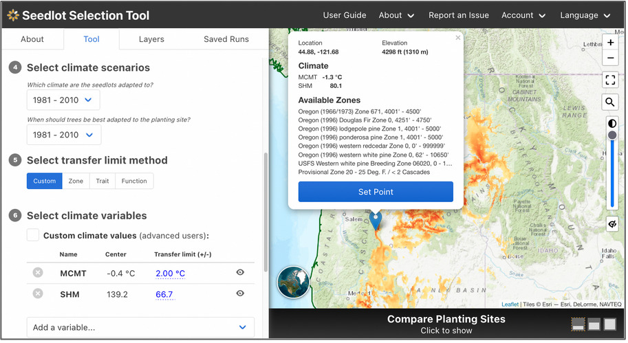
The Seedlot Selection Tool (or SST) is a free web-based decision-support tool that can be used to map planting locations based on either current climate data or a range of possible future climates across the conterminous U.S. and Mexico. Users can select a tree species, a climate scenario and relevant climate variables for the species, and other parameters to identify sources of seedlots appropriate for planting on a particular site or planting sites that are appropriate for planting seedlings from a particular seedlot. A valuable planning and educational tool, the SST helps explore possible future conditions, assess risk, and plan potential responses as part of a decision about which seedlot seedlings will be best adapted to a particular planting site in the future.
Seedlot Selection Tool Guidebook for US Forest Service Region 6 Silviculturists
Seedlot Selection Tool Video Tutorial for US Forest Service Region 6 Silviculturists
The SST was spearheaded by Glenn Howe at Oregon State University and Brad St. Clair at the USFS Pacific Northwest Research Station and developed by Nikolas Stevenson-Molnar, Brendan Ward, and Dominique Bachelet at CBI. Recently the USDA Climate Hub and USFS Region 6 staff worked with CBI to develop a step-by-step Guidebook and Video Tutorial for the Seedlot Selection Tool for Region 6 Silviculturists. These materials are useful to anyone who wants to learn about the use of this resource.
You may access the SST and detailed instructions at https://seedlotselectiontool.org/sst/.
Please see the USDA Climate Hub Seedlot Selection Tool Web Page for more information about the Guidebook and Tutorial Video.
Support for the SST came from the USFS, OSU, CBI, and the USDA Northwest Climate Hub.
CBI is expanding on previous work with the Peninsular Florida Landscape Conservation Cooperative (PFLCC) to further develop the PFLCC Simple Viewer to provide greater functionality and flexibility. In March 2017, CBI worked with PFLCC to incorporate PFLCC’s Blueprint version 1.0 into the viewer, and also created new reporting functionality to export on-screen results to PDF. In July 2017, CBI introduced the ability to aggregate multiple watersheds for display of summary information. This is particularly useful for users whose areas of interest and jurisdictions span multiple watersheds.
CBI is currently working on creating a Conservation Actions Tracker that will be added to the PFLCC Conservation Planning Atlas developed by CBI using Data Basin. This Conservation Actions Tracker will to allow users throughout Florida to enter information about conservation actions on the landscape – such as restoration activities – using an intuitive map-oriented interface. Users will also be able to explore any conservation actions in the system, and discover opportunities for collaboration and shared impact.
CBI is in the process of designing a new interactive application to showcase the PFLCC climate change adaptation guide so that users will be able to use interactive maps and data visualization to gain a greater understanding of climate change adaptations within Florida landscapes.
CBI is working with Utah’s Division of Wildlife Resources (DWR) and The Bureau of Land Management to develop decision support models to inform current conservation initiatives in Utah and throughout the Colorado Plateau ecoregion. Based on previous REA (Rapid Ecoregional Assessment) work, CBI is updating the existing terrestrial landscape and aquatic intactness models for the Colorado Plateau ecoregion as well as updating habitat profiles for a number of identified conservation elements of interest (largely native species and communities). CBI is extending the models to cover the entire state of Utah as well as fine-tuning the models to be more effective at answering different management questions over smaller geographic areas.
CBI is also updating a previously created climate stress logic model with the most recent climate data from the 5th Intergovernmental Panel on Climate Change (IPCC) report as well as carryout some new analyses. For example, mapping potential climate refugia – areas where plants and animals may find shelter from changes in climatic conditions. CBI is also examining past and future climate variability to model climate velocity, which is the speed along the Earth’s surface needed to maintain constant climate conditions with the rationale being that species survival may depend as much on keeping pace with moving climate as the climate’s ultimate persistence. Results of the climate modeling will illustrate at the landscape level the degree to which locations in the landscape will be impacted by climate stress over the next century and help estimate the likelihood that certain species will survive shifting suitable habitat conditions.
Click here to see the console.
CBI is providing scientific and technical support to Greenpeace Canada and AV Terrace Bay as they work together to maintain the ecological integrity of the Kenogami-Ogoki Forests in Ontario, Canada while providing a sustainable wood supply to the AV Terrace Bay mill and protecting cultural values of First Nations peoples.
There are two major, interrelated components of the project. First, CBI is examining a series of important aspects of woodland caribou conservation in the region, which has been a major focus throughout boreal Canada for a number of years as ongoing development is continually eroding woodland caribou habitat resulting in serious declines in some populations. Using data provided by the Ontario government, CBI is attempting to identify key caribou activity areas, regional movement patterns, and crucial habitat.
CBI is also creating a series of risk-based protected areas scenarios by defining areas of high landscape value and high biological value. High biological value is determined by considering representation of native ecosystems, overall forest values, concentrations of rare species, wetlands, and vital woodland caribou habitat.
Upon development of the scenarios, CBI will facilitate a discussion to review the trade-offs of the different scenarios between AV Terrace Bay and Greenpeace Canada, using Data Basin to support the discussion given the spatially explicit nature of the effort. In the end, the hope is to forge a land management agreement between the two parties that will allow for sustained economic development of the forest resources while protecting the ecological integrity of the region (including woodland caribou viability) and cultural values of the local First Nations peoples.
The Conservation Biology Institute, in collaboration with Ted Weller (USFS – Pacific Southwest Research Station) is expanding the functionality of Data Basin to create a clearinghouse for migratory bat detection data. This new functionality will allow users to: (1) import location-aware spreadsheet data into Data Basin; (2) dynamically visualize these locations and their attributes (such as number of bats of a particular species) within the interactive map; and, (3) explore charts of time series records across one or more locations. Additional tools under development will allow aggregation into a single master dataset, support form-based imports to more easily capture site and detector information from researchers during upload, and support export of records into spatial and non-spatial outputs.
More information about the exciting implications of this project can be found within an article on The Wildlife Society website.
Working as a subcontractor to Dynamac Corporation, the Conservation Biology Institute provided the scientific leadership and technical support for two BLM Rapid Ecoregional Assessment (REAs). The Sonoran Desert ecoregion was completed in the spring of 2012. A series of conservation elements were chosen for the eocregion and over 40 management questions addressed. Most questions pertained to a listed set of change agents, including urban and agriculture development, energy (including renewables), fire, invasive species, recreation, and climate change. For each conservation element, conceptual models were created and, for each specific management question, an accompanying GIS-based process model was created that outlined the data and steps necessary to generate an answer to the question. Part of the project required an exhaustive acquisition and review of available spatial data – hundreds the ecoregion. Extensive and sophisticated modeling had to be applied to multiple topics including target species habitat, natural ecological systems, climate change, invasive species, wildfire, and landscape integrity. Also, some custom analytical software had to be generated throughout the course of the project.
Project review was conducted using Data Basin and final results reside in a private group space on this web-based data management and mapping system. To inquire about access to the data and map-based results, please contact Karen Prentice at BLM Headquarters (kprentice@blm.gov).
To download the report and find out more information, Click Here.
Working as a subcontractor to Dynamac Corporation, the Conservation Biology Institute provided the scientific leadership and technical support for two BLM Rapid Ecoregional Assessment (REAs). The Colorado Plateau ecoregion was completed in the spring of 2012. A series of conservation elements were chosen for the eocregion and over 40 management questions addressed. Most questions pertained to a listed set of change agents, including urban and agriculture development, energy (including renewables), fire, invasive species, recreation, and climate change. For each conservation element, conceptual models were created and, for each specific management question, an accompanying GIS-based process model was created that outlined the data and steps necessary to generate an answer to the question. Part of the project required an exhaustive acquisition and review of available spatial data – hundreds the ecoregion. Extensive and sophisticated modeling had to be applied to multiple topics including target species habitat, natural ecological systems, climate change, invasive species, wildfire, and landscape integrity. Also, some custom analytical software had to be generated throughout the course of the project.
Project review was conducted using Data Basin and final results reside in a private group space on this web-based data management and mapping system. To inquire about access to the data and map-based results, please contact Karen Prentice at BLM Headquarters (kprentice@blm.gov).
To download the full report and find our more information on the Colorado Plateau REA, click here.
Wolves were extirpated from the Adirondacks over a century ago due largely to human eradication efforts. The Conservation Biology Institute (Corvallis, OR) was chosen by the Adirondack Citizens Advisory Committee to examine the question of biological feasibility of reintroducing gray wolves back to the Adirondacks. By applying what is known about gray wolf ecology (in general) to the best available spatial and genetics data for the Adirondacks, we examined three basic questions:
- Is there suitable gray wolf habitat in the Adirondacks to support a viable population?
- Is there adequate landscape connectivity both within the Adirondacks and between the Adirondacks and the surrounding region to allow for reasonable gray wolf movement important to their persistence?
- What does the most recent genetics tell us about wolves in the Adirondacks?
The Klamath-Siskiyou ecoregion of southwest Oregon and northwest California has long been recognized for its global biological significance and is considered an Area of Global Botanical Significance by the World Conservation Union, a global Centre of Plant Diversity, and has been proposed as a possible World Heritage Site. More recently, World Wildlife Fund US scored the Klamath-Siskiyou as one of their Global 200 sites reaffirming its global importance from the standpoint of biodiversity.
CBI used GIS as the principle tool to assess the state of the environment in the Klamath-Siskiyou and to develop a reserve design proposal based on the three-tracks. GIS is a computer-based analytical mapping technology that is rapidly becoming the cornerstone for conservation planning at many different spatial scales.
The proposed work plan called for the analysis to be focused at the 1:100,000-map scale using the best available data. While the 1:100,000 remained our target planning scale, we incorporated larger scaled data (e.g., 1:24,000) wherever possible. Doing so allowed for much more meaningful and reliable analyses. One of the greatest challenges throughout this project was evaluating and integrating the various data layers acquired from numerous sources.
The purpose of this project was to create a GIS-based model that identifies specific focal areas throughout the range of the redwoods. Focal areas were defined as zones that offer the best conservation opportunities for long-term protection and maintenance of the redwood ecosystem based on current conditions. GIS was utilized because of its spatially explicit architecture and advanced analytical capability.
This model was produced for Save-the-Redwoods League as part of their overall Master Plan – an organizational blueprint for protecting the redwood ecosystem. More specifically, this model was intended to help the League target their future proactive conservation planning efforts more effectively as part of their overall conservation mission while supplying a broader organizational tool that could be shared with its conservation partners in the region.