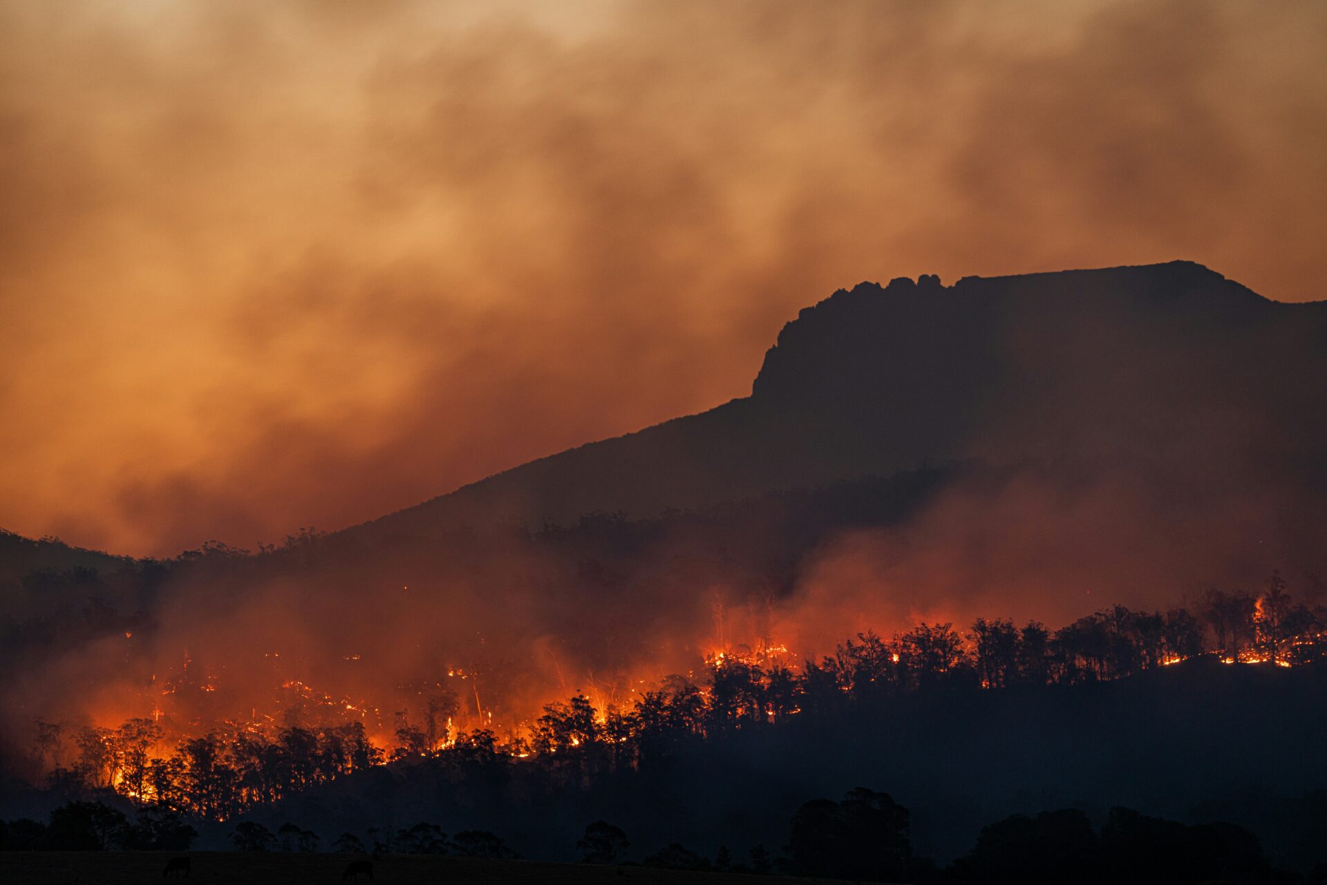
Wildfires are transforming ecosystems and threatening communities across the globe, but not in the same way everywhere. Fire regimes are shifting differently region by region, shaped by distinct combinations of climate, land use, vegetation, and human settlement patterns. A management strategy that improves resilience in one place can backfire in another. In 2024, Conservation Biology Institute (CBI) launched the Global Wildfire Collective (GWC) to help close this gap—creating a central, international hub where fire science, policy, and lived experience can meet, and where lessons learned in one region can be responsibly translated for use in another.
FIRE:NET builds on the GWC’s early momentum, during which the initiative grew to include more than 42 charter member experts and 14 partner institutions, representing 26 countries, launched a multilingual discussion forum, and secured endorsements from United Nations focal points in more than 23 countries for a proposed Joint Work Programme on Wildfire Resilience and Recovery. This project puts that foundation to work through a comparative research design built around three contrasting regions: California and south-central Chile, a classic pair of Mediterranean-climate systems whose shrublands evolved independently yet converged on strikingly similar form, and the Colombian Amazon, a tropical moist-forest frontier where fire is largely new to the landscape. Together, the three sites form a controlled comparison nested within a strong ecological and social contrast—letting the team ask which drivers and impacts of fire activity generalize across very different fire systems and which are highly context-specific.
Across all three regions, researchers are already seeing a shared trajectory: a shift toward more flammable, non-native-dominated vegetation. But the trigger differs by region. In California, short-interval fire and climatic drying are converting native chaparral shrublands to flammable invasive grassland. In the Colombian Amazon, fire promotes invasion by pasture and cerrado grasses that make the landscape more fire-prones. In Chile, decades of subsidy-driven pine and eucalyptus plantation expansion built a flammable landscape that recent megafires have since consolidated. What generalizes is the feedback loop and the flammable endpoint; what is context-specific is the trigger and the vegetation that replaces the native system—exactly the kind of divergence in mechanism and convergence in outcome, that the project is designed to test.
The research unfolds through three coordinated components. The first, led by Andrés Holz and Jonathan Fink of Portland State University, characterizes each region’s coupled human-natural fire system—its historical and altered fire regime, its ecological transformation trajectory, and its human exposure, vulnerability, and Indigenous and local relationships to fire—and co-produces living resilience roadmaps from that synthesis. The second introduces a new Wildland-Human Interface (WHI) typology, led by CBI’s Alexandra D. Syphard together with Chilean collaborator Alejandro Miranda, that generalizes the conventional Wildland-Urban Interface concept beyond its house-centric assumptions. This allows it to also describe frontier and tropical landscapes, and treats the management objective—protecting people versus protecting ecosystems—as an explicit dimension rather than a fixed default. The third, led by Alexandra D. Syphard and Heather Rustigian-Romsos from CBI, harmonizes globally consistent wildfire, vegetation, and settlement datasets into cross-regional machine-learning models, explicitly testing which relationships between fire, ecological transformation, and human exposure hold steady across regions and which require local calibration.
Digital infrastructure remains central to the effort. Building on the GWC’s existing Spatial Data Gateway and Discussion Forum, the project is developing a new AI-powered Knowledge Base to help members across regions and languages find relevant data, tools, and expertise. The Global Wildfire Collective Academy’s webinars, regional workshops, and cross-node retreats continue to build capacity and strengthen ties between local, national, and international fire networks, while ongoing engagement with UN convention secretariats advances science-informed policy at a global scale.
This project is funded through the U.S. National Science Foundation (NSF) Fire Science Innovations through Research and Education (FIRE) program, a collaboration among NSF, NASA, DOD SERDP/ESTCP and the Gordon and Betty Moore Foundation to advance wildland fire research. This funding is administered by the Buckminster Fuller Institute.
For more information about this effort, please contact Alexandra D. Syphard at asyphard@consbio.org.
Please see the Global Wildfire Collective website for more information about the GWC’s mission, membership, and digital tools.
Subawardees: Jonathan Fink, Ph.D. (Portland State University) · Andrés Holz, Ph.D. (Portland State University)
In 2016, the California Energy Commission funded the Conservation Biology Institute to undertake an advanced landscape condition analysis to use as a foundation for evaluation of ecosystems, species’ habitats, and areas planned for renewable energy development. This was subsequently incorporated into programmatic assessments by multiple State agencies, including the California Department of Forestry and Fire Protection’s Fire and Resource Assessment Program (FRAP 2017 Assessment) and the California Department of Fish and Wildlife’s State Wildlife Action Plan (SWAP 2025 Update).
The modeling approach employed by CBI synthesizes complex spatial information into a suite of accessible metrics to quantify terrestrial intactness, an estimate of the naturalness – or lack of human disturbance across the landscape – through a multidimensional lens. The resulting interactive product allows for identification of intact natural areas that maintain ecosystem integrity, thus maximizing support of wildlife and ecosystem services returned to Californians. It also highlights factors affecting the State’s landscape condition, such as infrastructure/urban development, and facilitates understanding the multitude of human impacts co-occurring along that continuum.
In 2024, the California Department of Forestry and Fire Protection (CAL FIRE) funded an update to produce a new version of this terrestrial intactness product, incorporating the most recent data on landscape impacts and providing a more comprehensive view of important considerations with new invasive vegetation and habitat fragmentation metrics. This analysis provides a present-day estimate of the degree to which California’s natural landscapes have been impacted by human disturbance and the drivers at play in any given location. The updated model and accompanying dataset’s comprehensive attribute information can be used for a variety of applications by both agencies and NGOs. These include characterization of intact natural areas that maximize ecosystem services to communities, such as access to nature and improvements in water quality, as well as assessment of ecosystem and species’ habitat condition, considering how various human impacts can be mitigated via strategic planning and targeted restoration efforts.
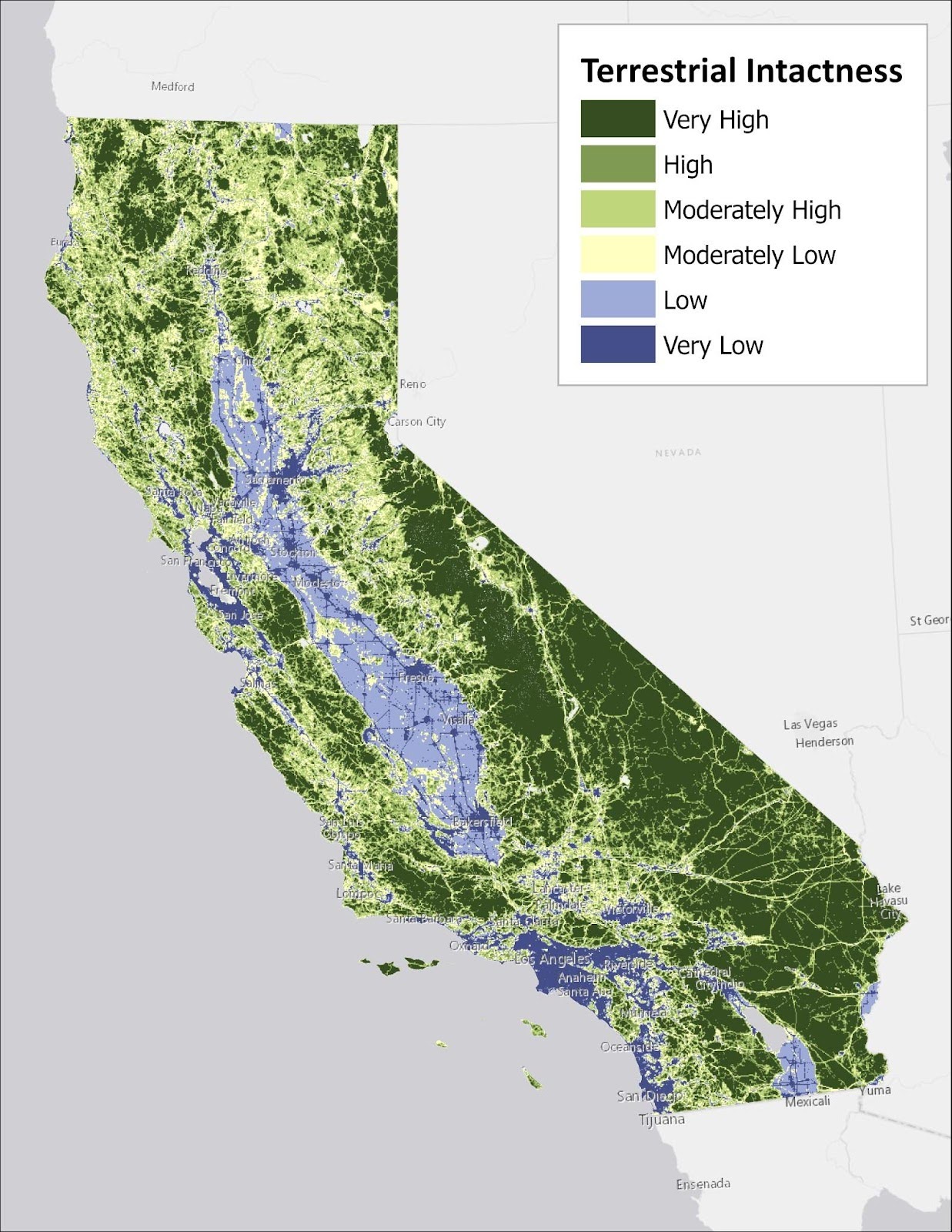
Significant improvements in data availability and quality inform the updated version of the landscape intactness product, as well as new metrics described above. The 2016 version was limited by lower quality input data and less sophisticated land cover mapping techniques than are currently available. The 2025 version has been crafted with an eye towards incorporating data derived from more advanced methods, likely to be updated at regular intervals, thus setting the stage for products more directly comparable across time. These upgrades and advancements in the analytical platform provide a basis for future work, such as finer resolution modeling that offers additional detail and functionality to the agencies, NGOs, and decision makers using CBI’s products to support scientifically-rigorous management of California’s resources.
Check out this article by LAist, featuring CBI’s Dr. Alexandra Syphard, taking a look at why some houses burn but not others – especially in regards to the recent L.A. fires.
‘A lot of houses actually catch fire from inside the structure first without even catching on fire from the outside, because the ember gets in,’ explained Alexandra Syphard, a research ecologist with the Conservation Biology Institute and an adjunct professor at San Diego State University. In rural areas, where houses are spaced widely apart, ember-ignition accounts for nearly all of the houses that burn down, Syphard’s research has shown.
Check out this article by the L.A. times, featuring CBI’s Dr. Alexandra Syphard, analyzing how the recent in L.A. fires began, and how fires like these are able to spread and grow to such significant scales.
While Santa Ana winds regularly occur at this time of year, these particularly strong gusts came through complex topography and terrain that can help them gain speed and funnel them in unpredictable ways, said Alexandra Syphard, senior research ecologist at the nonprofit Conservation Biology Institute and adjunct professor at San Diego State University. ‘When you’ve got winds like this, the fire is no longer spreading through the vegetation on the ground,’ she said. ‘The fire is spreading through the air.’
Check out this article by the LA Times, featuring CBI’s Dr. Alexandra Syphard, about the Palisade fire and what could have been done to reduce the risk.
That’s because the Santa Monica mountains, Malibu canyons and other wildland areas near coastal Los Angeles generally burn too frequently, said Alexandra Syphard, senior research ecologist at the nonprofit Conservation Biology Institute and adjunct professor at San Diego State University.
Check out this CalMatters publication, featuring CBI’s Dr. Alexandra Syphard, about the critically dry conditions in L.A. and what role those conditions played in the recent L.A. fires.
Alexandra Syphard, a senior research ecologist at the Conservation Biology Institute and an adjunct professor at San Diego State University, said the extreme conditions have rendered humans powerless, at least in the near term, to subdue wildfire threats. ‘I do not believe there is anything that wildland management could have done to qualitatively or substantially alter the outcome of these fires,’ she said.
Check out this CalMatters article, featuring CBI’s Dr. Alexandra Syphard, about why California continues to place new developments where wildfires are likely to occur.
No matter the other precautions a homeowner or local government might take, ‘you’re still taking a gamble when you place a new development out in an extraordinarily fire-prone environment,’ said Alexandra Syphard, an ecologist at the Conservation Biology Institute who studies how land-use decisions affect wildfire risk. ‘Simply by the law of numbers, the more people you have in an area like that, the higher your likelihood that one of those people will start a fire and the higher the likelihood that that fire is going to reach a house,’ she said.
With historic intensity and severity, the recent L.A. fires have been a catalyst for scientific research surfacing nearly every news article, publication, and journal – many of which feature Conservation Biology Institute’s very own, Dr. Alexandra Syphard. Take a look at the PNAS article, How towns can adapt to fire as bigger burns loom.
Firefighters and land managers have been using fuel breaks for decades, but only recently have actual studies emerged suggesting that fuel breaks can reduce fire severity and damage (1). Fuel breaks “can work and can alter fire behavior,” especially in forests—where the majority of this research has been done—says Alexandra Syphard, a senior research ecologist at the Conservation Biology Institute, headquartered in Corvallis, Oregon. Forests are good candidates for fuel breaks because breaks mimic what natural fires would have done in the past, thinning out the understory every so often, so there’s not an accumulation of massive tinder to burn.
Abstract:
“Wildfires can be devastating for social and ecological systems, but the recovery period after wildfire presents opportunities to reduce future risk through adaptation. We use a collective case study approach to systematically compare social and ecological recovery following four major fire events in Australia and the United States: the 1998 wildfires in northeastern Florida; the 2003 Cedar fire in southern California; the 2009 Black Saturday bushfires in Victoria, southeastern Australia; and the 2011 Bastrop fires in Texas. Fires spurred similar policy changes, with an emphasis on education, land use planning, suppression/emergency response, and vegetation management. However, there was little information available in peer-reviewed literature about social recovery, ecological recovery was mostly studied short term, and feedbacks between social and ecological outcomes went largely uncon- sidered. Strategic and holistic approaches to wildfire recovery that consider linkages within and between social–ecological systems will be increasingly critical to determine if recovery leads to adaptation or recreates vulnerability.
Southern California’s montane conifer forests are primarily restricted to the “sky islands” of the San Jacinto, San Bernardino, and San Gabriel Mountains. These unique ecosystems protect the upper watersheds of all of the region’s major rivers and provide ecosystem services critical to both human and ecosystem climate resilience. Managers are in a race to restore resilience to these forests, which are threatened with conversion to hardwood and shrub due to severe wildfires and regeneration failure.
This partnership between the US Forest Service, San Diego State University, and Conservation Biology Institute is applying the latest research on interactions between multiple disturbances specific to this ecoregion to plan effective conservation action.
The effort expands on research from the Connecting Wildlands and Communities project that developed a landscape-scale framework to map refugia from multiple stressors, and ongoing research projects at CBI developing dynamic wildfire and vegetation succession models for understanding the synergistic impacts of climate change, land use change, and different management scenarios.
The team will work with scientists and managers to build interactive spatial models using CBI’s Environmental Evaluation Modeling System (EEMS) with location-specific data to support the collaborative development of a conservation strategy customized to address the threats faced by southern California’s montane forests.