In 2016, the California Energy Commission funded the Conservation Biology Institute to undertake an advanced landscape condition analysis to use as a foundation for evaluation of ecosystems, species’ habitats, and areas planned for renewable energy development. This was subsequently incorporated into programmatic assessments by multiple State agencies, including the California Department of Forestry and Fire Protection’s Fire and Resource Assessment Program (FRAP 2017 Assessment) and the California Department of Fish and Wildlife’s State Wildlife Action Plan (SWAP 2025 Update).
The modeling approach employed by CBI synthesizes complex spatial information into a suite of accessible metrics to quantify terrestrial intactness, an estimate of the naturalness – or lack of human disturbance across the landscape – through a multidimensional lens. The resulting interactive product allows for identification of intact natural areas that maintain ecosystem integrity, thus maximizing support of wildlife and ecosystem services returned to Californians. It also highlights factors affecting the State’s landscape condition, such as infrastructure/urban development, and facilitates understanding the multitude of human impacts co-occurring along that continuum.
In 2024, the California Department of Forestry and Fire Protection (CAL FIRE) funded an update to produce a new version of this terrestrial intactness product, incorporating the most recent data on landscape impacts and providing a more comprehensive view of important considerations with new invasive vegetation and habitat fragmentation metrics. This analysis provides a present-day estimate of the degree to which California’s natural landscapes have been impacted by human disturbance and the drivers at play in any given location. The updated model and accompanying dataset’s comprehensive attribute information can be used for a variety of applications by both agencies and NGOs. These include characterization of intact natural areas that maximize ecosystem services to communities, such as access to nature and improvements in water quality, as well as assessment of ecosystem and species’ habitat condition, considering how various human impacts can be mitigated via strategic planning and targeted restoration efforts.
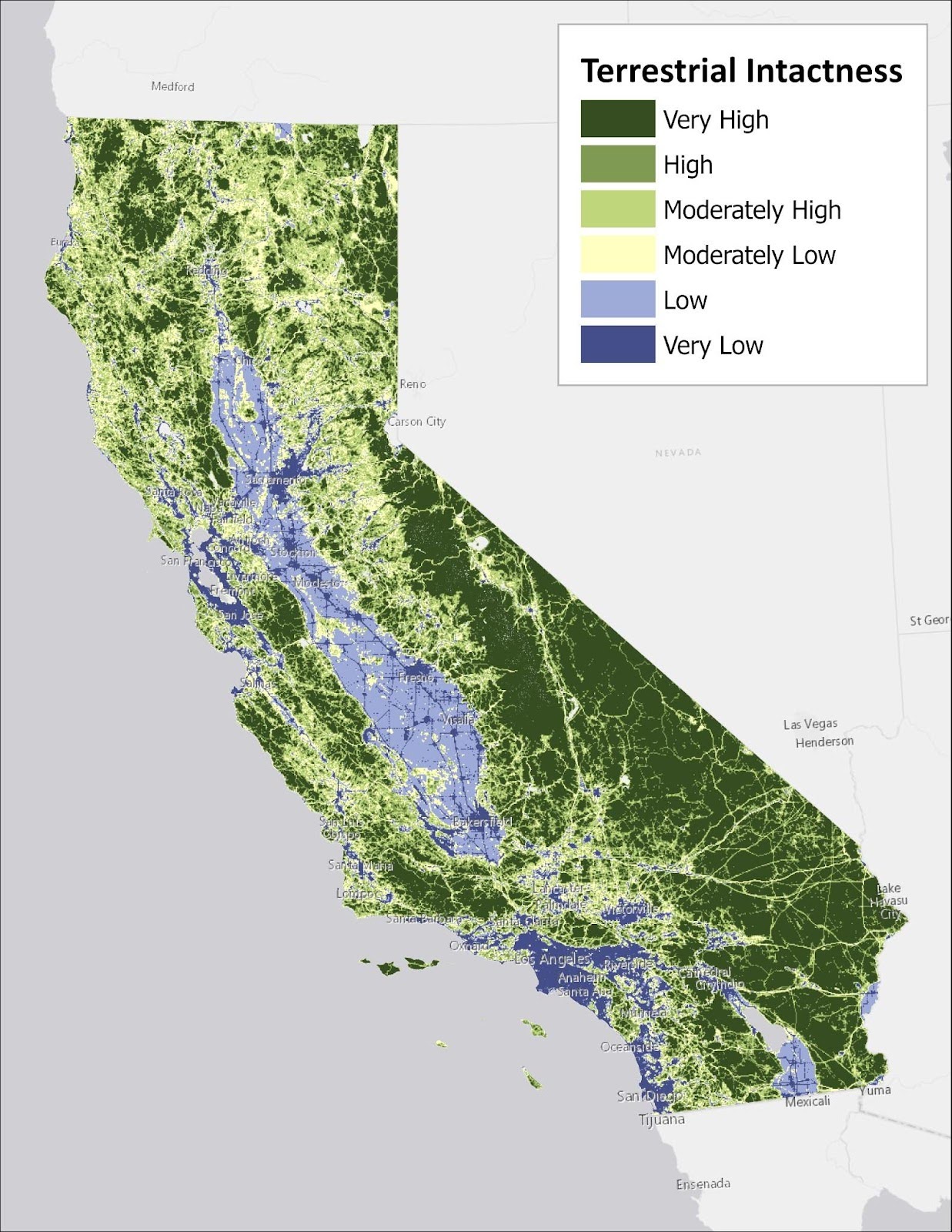
Significant improvements in data availability and quality inform the updated version of the landscape intactness product, as well as new metrics described above. The 2016 version was limited by lower quality input data and less sophisticated land cover mapping techniques than are currently available. The 2025 version has been crafted with an eye towards incorporating data derived from more advanced methods, likely to be updated at regular intervals, thus setting the stage for products more directly comparable across time. These upgrades and advancements in the analytical platform provide a basis for future work, such as finer resolution modeling that offers additional detail and functionality to the agencies, NGOs, and decision makers using CBI’s products to support scientifically-rigorous management of California’s resources.
Project Details
Location
Date
Services Provided

Data Basin

Scientific Research & Modeling

Spatial Analysis & Mapping