
Software Details
Related Resources
Related Posts
CBI Contact

CBI Authors + Contributors


The Conservation Biology Institute’s Environmental Evaluation Modeling System (EEMS) is a fuzzy-logic modeling framework that can be applied to a wide range of conservation and planning applications. With EEMS, data of different types and formats from multiple sources can be combined to answer questions such as current and future habitat value, ecological/development conflict, and landscape vulnerability to climate change.
To use EEMS, a user builds a tree-based logic model in which the bottom nodes represent the initial data inputs. These data values are converted into fuzzy values (based on the premise that each input value can be represented by a value ranging from -1 for fully false to +1 for fully true). Fuzzy logic operations (analogous to basic logic operations such as AND and OR) are then used to combine nodes hierarchically until a final value representing the answer to a research question, (e.g., what is the relative value of endangered species habitat across our study area?), is produced.
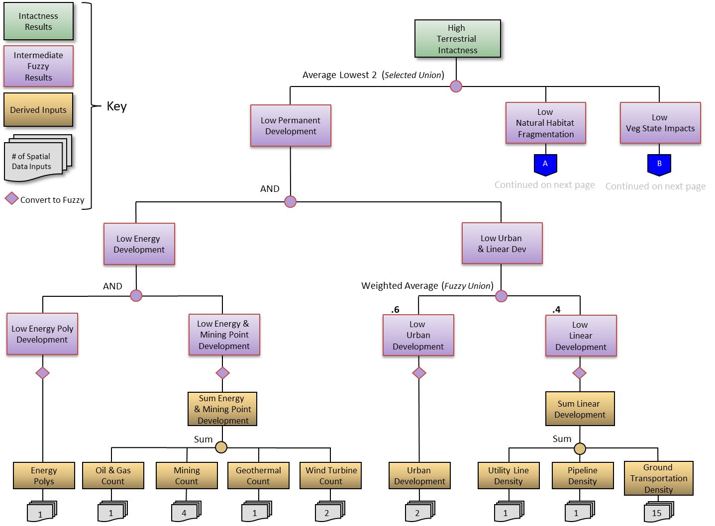
There are many advantages to this data-driven modeling approach: (1) it’s highly interactive and flexible; (2) it’s easy to visualize data sources and analysis structure; (3) components are modular, making it easy to add or exclude information; (4) model parameters can be adjusted using a number of different mechanisms; and (5) numerous data of different types can be included into a single integrated analysis.
EEMS modeling has been applied by CBI scientists in a wide range of planning and ecological applications. In the Tehachapis and Southern Sierra, a model incorporating data for habitat presence, habitat linkage, and disturbance was used to find areas of high ecological value and to provide guidance for reserve design to inform siting renewable energy infrastructure. For the Bureau of Land Management Rapid Ecological Assessments of the Sonoran Desert and Colorado Plateau ecoregions, EEMS models were developed and used to evaluate a variety of current and projected ecological metrics such as landscape and aquatic intactness. This approach has also been used to support the State of California’s offshore wind renewable energy planning process via the development of EEMS models to help assess a range of important considerations such as wind energy potential, deployment feasibility, ocean uses, fisheries, and marine life occurrence.
EEMS Visualization and Exploration Tools
EEMS Explorer is a tool integrated into CBI’s Data Basin platform that allows users to examine EEMS models in a dynamic web-mapping environment. It provides an interactive model diagram coupled with a map display that allows users to “drill down” on an EEMS model to examine its structure, data, and logical relationships. This gives scientists and land managers the ability to determine what landscape metrics are driving model results at any given location.
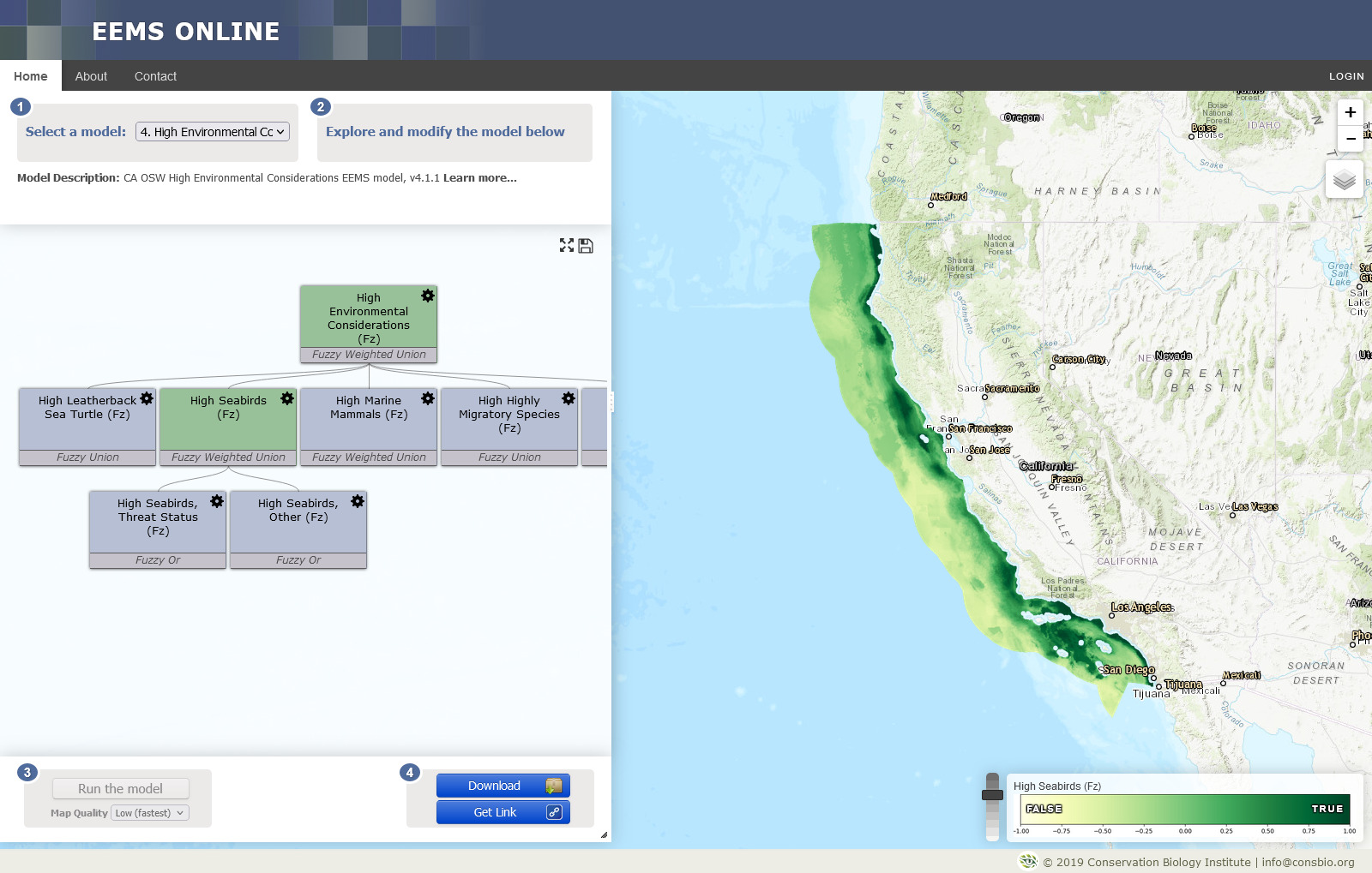
EEMS Online provides another avenue for users to visualize and interact with EEMS models in a web environment. In addition to providing a rich and powerful set of tools for examining a model’s structure, data, and logical relationships, it helps facilitate the EEMS model development process by allowing users to modify a model’s parameters (e.g., weights, thresholds, and operators) to see how these changes affect the results. The modified model can then be shared among project team members, collaborators, and stakeholders for evaluation and feedback.
The combination of EEMS, EEMS Explorer, and EEMS Online provides a powerful system for the development, dissemination, and evaluation of complex models in a way that is both transparent and accessible. By helping to bridge the gap between science and technology, CBI’s EEMS modeling platform has become an important tool in helping to guide and inform conservation management and planning decisions.
Getting Started
EEMS is written in Python and maintained as a collection of libraries within MPilot– a plugin-based, environmental modeling framework developed by CBI.
EEMS Pro is an ArcGIS implementation of EEMS that interfaces with these libraries and allows users to construct models visually using ESRI’s ModelBuilder environment.
Models can be developed using either platform, however EEMS Pro is recommended for those with experience with ArcGIS and Model Builder.
EEMS Pro is compatible with both ArcGIS Desktop (>=10.6) and ArcGIS Pro. To get started with EEMS Pro, download the latest version here, which includes the EEMS Pro toolbox, a manual with installation instructions, and a set of tutorial data.
Learn More
See “Related Resources” on the upper right of this page.
For an introduction to EEMS in ArcGIS, an explanation of the fuzzy logic concepts EEMS uses, and a demonstration of the EEMS Model Explorer, please click here to view a recorded webinar.
To view a recorded webinar titled “Decision-support for regional reserve design and siting of renewable energy and infrastructure”, please click here.